Yet another 50! Walk 40 – 15/06/2022

Life has got in the way of walking and I hadn’t done anything other than walk into town since coming back from Ireland. This wasn’t good as I had a big challenge coming up! So I decided I must go for a walk but it had to be a long one! Well I certainly succeeded in that – and it was the hottest week of the year!

Took a while to decide what to do – should I drive somewhere or go from home – I the end I chose the latter. Having studied the map I decided to head towards the Ridgeway and then over the other side to East Ilsley and back home ! I did measure it roughly – a bit of a shock but I decided that’s what I’d do.

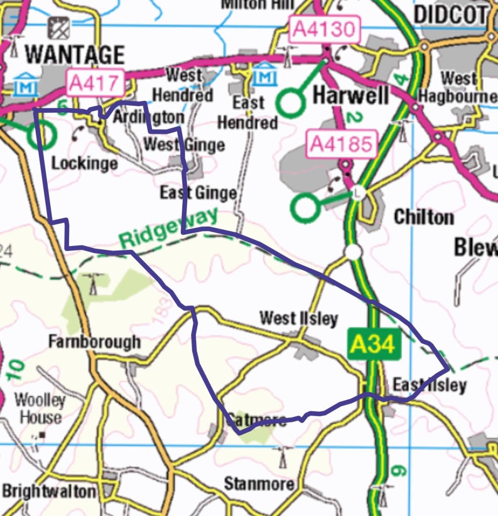
So straight up Larkhill until the track reaches the road and then turns left. When the boys were younger this track always seemed a wide muddy stretch but now it has much more vegetation and the actual path is quite narrow. Next to walk upwards again and next to the gallops, as these are rounded off at the end the path turns left again and through some woods. This is a diagonal way to get up on to the Ridgeway and misses the monument. It does take about an hour of walking to get to this point.

A very short distance along the Ridgeway and then crossing over to the other side. ‘Old Road’ heads downwards for a good distance- I only discovered this great path a few weeks ago and that time I was coming up rather than down and was lucky enough to see hares playing. I love the variety of grasses that are evident at this time of the year.

The path crosses the road and I’m now going on a section which I had walked with Alex and Pete in the other direction. After a while it’s a turn left through the wood and again a track I had traversed the other direction on a previous occasion with a walk started in Farnborough. I soon get to a point where I carried on walking towards East Ilsley, I’d been at this junction before but not carried on in this direction.

I am somewhat amused at the markers showing mileage and direction which have been put in place for the Uptonogood cycle event that is due to take place the following Saturday. It was good to think that whilst I was doing the BBQ at the event I’d have some idea where the different groups of cyclists were going. I certainly didn’t envy them some of the narrow overgrown routes.

I do eventually get to East Ilsley having gone underneath the A34 as I entered the village. Cars obviously but even here hardly any people around – probably because it is so hot! The route follows one of the roads out of the village and I’m pleased to see a proper path set into the bank, parallel to the road as it was going to be a difficult walk up the road round a sharp bend.

Quite quickly the path diverts up towards the Ridgeway, luckily a gentle slope up and soon I’m back on the top. I come out on the Ridgeway at a point where it turns a right angle. This is an area of the Ridgeway walk where you have to concentrate on navigation. So back going West and the next marker would be going under the A34 again – still more cycle signs.

I’ve walked this section a couple of times and I knew that the next point was the car park. I felt I was beginning to struggle at this point – I didn’t hurt but had real self doubt as to whether I had sufficient energy to get home! I think the extreme heat was beginning to get to me, although there was a bit of a breeze. I found myself checking my map – totally unnecessary action and looking back to see how far I had come! I did tell myself there was no other choice than to keep walking! A short section after the car park there was a bench judiciously placed next to the path. I hadn’t sat down up until this point and I gave in and sat down- previously I had eaten standing up. I was aware of time as I had left rather later than ideal to do this long walk. So a sit and an apple later I set off feeling somewhat revived.

So passed the turning down to East Hendred and another car park and now looking out for the path down to Ginge that so found a few weeks ago. Really enjoyed walking down this and had a spring in my step again. There were various possibilities as I arrived in Ginge . I decided to take the footpath on the eastern side of the Brook. Nearly a year since I’d walked here – the path was good to begin with and then as before it became very overgrown – you could just see the path but due to the heat I had decided to wear shorts – good option until this point! Stinging nettles and bare legs don’t mix well! Very stung knees! Glad to see that the far end of the path was also good – that’s a bad trick enticing you in!

Over the new bridge and along a familiar track and a turn right down towards Ardington. At this point I was finding the quickest route to home. A familiar section near Barton House. I can’t resist a field of cows, something peaceful, rural and very English. By now it was just gone 8 pm and just less than half an hour to home!

This walk was 18.5 miles long – perhaps not the most sensible option for a hot day but it taught me a lot and hopefully prepared me for my next walk!

Yet another 50! Walk 39 – 03/06/2022

So there was supposed to be a half day walk scheduled for today but Steve didn’t appear keen to organise anything. Mostly due to our travel arrangements – we would be leaving Spiddal at 23.15 to drive back to catch the 07.30 ferry – so extra sleep time was required. Mirella and Annie decided to visit the island and they were picked up to catch the earlier ferry from Spiddal.

So Sheila, Tom , Jack and myself decided we really would do a coastal walk even though we had no actual idea whether there would be a path! We knew that there was one close to Spiddal but we weren’t sure before that.

We got a lift to Barna which was about 7 miles down the road towards Galway and we knew had a road leading down to the bay. We started by going in search of some lunch and Jack and Tim both had large Irish breakfast so no longer needed to buy lunch!

It was a matter of picking our way along the top of the beaches and occasionally there was a small path along a narrow grassy ledge but nothing like coastal paths in England.

We passed across the back of a large hotel and for a short while there was a path – I don’t think they were expecting their guests to walk very far. At this point we diverted back up to the road as Tom needed water and we also needed to avoid some building work which went right down to the shore line.

Having followed a lane back down to the beach we were following a particularly difficult section of non path – sometimes the boulders we were walking in were like crossing ball bearings, especially if you ended up on a slope.

We then came to a place which had more of the large stone wall we had been following and a difficult walk way on the beach – there was a huge piece of land and a gate in the wall and a wonderful flat path on the other side. Very naughtily the three of them climbed over whilst I wriggled underneath. Sheila and I set off and somebody came out of the house and started shouting at us – we carried on and the two men tried to reply. We put our heads down, apparently if we did it again she would call the police – as this was our only excursion along here we carried on!

The path just continue next to the wall and then stopped as it met another perpendicular wall, so it wasn’t actually going anywhere. At which point we had to climb back over the wall and regain our freedom – it was nice walking on a flat path for a short while though!

Shortly after this we did start seeing yellow way mark signs – not that they actually indicated a path! It was great to be walking next to the water but it was by no means an easy walk and the seven miles by road turned into nearly 11 as we twisted and turned around the intricacies of the shore line.

We kept thinking we would spot Spiddal church tower but we didn’t until we were very close but we did see the harbour pier in the distance, which at that point was very reassuring.

When we reached Spiddal Beach Sheila and I detoured away from the shoreline to visit the craft village and hopefully find tea! Tom and Jack stayed and got wet in the sea. We did find tea further on in the village in a little shop and we managed to sit outside for a short while to drink it before she closed and we had to abandon our seats. Cheekily we joined the other two in the hotel/ pub and sat with them whilst they finished their pints.

Then back up to the campsite to pack up tents and put everything in the van before coming back down for our evening meal and Irish Music in another pub. And then the long drive back! Well sleep for most of us!

It was good to feel very well exercised on the last day and the four of us had got on well together.

Yet another 50! Walk 38 – 02/06/2022

Having asked if we could do a coastal walk we actually went to a lake inland! After a very protracted drive and a couple of stops at some touristy gift outlets we arrived at Clifden Castle and some of us decided to go and explore- this wasn’t our main destination. Abandoned it wasn’t that old but turns out it was built by the Land owner when he developed Clifden.

We also ended up chatting to somebody working on the land who explained firstly that he was planting potatoes to attract more mice etc to try and bring back the owls that had been nesting in the ruins.

Then he pointed out the sounds and the flight of a ‘Chough’, a member of the crow family. He also explained that when the land owner left he handed over the land to his tenants, with each picking a straw to see which plots they would get. So this chap was farming on land bequeathed to his great grandfather. He also explained that the land still belonged to 5 of the original 9 families which made it more difficult for developers.

His last piece of information was that the standing stones were not ancient but had been put there to make it look more authentic, although he did tell American tourist they were scratching poles for cattle!

Next on to Ballynahinch Castle Hotel where we parked. We set of on a bit of a meander rather than a ramble. Firstly north westward along the lakeside to the old Mamor before we turned and came back the same way. a short section along the river and then through woodland touching on the edge of other lakes. As often happens a small break in the route when forgetting to restart the watch after a pause! So just over 9 kilometres.

There were a few good photo opportunities and we did manage to fit in a cup of tea just before the cafe in the walled garden closed.

Good to be back with the whole group but a slightly frustrating day.

Yet another 50! Walk 37 – 01/06/2022

Unofficial day off from walking today well put it this way we were offered another tough mountain venture – Sheila took up the challenge as she is walking in the Himalayas in October! Mirella and Annie decided to stay in Galway. So what to do? Having looked at the leaflet I realised we could probably pick up the bus to the ferry from our village and we could go to the isles of Aran. Realised too late for the early ferry but Jack and Tom agreed it would be a good alternative – so off to Inishmore Island. Great personal service – the bus driver had our paper tickets for the ferry!

Well the first idea was bicycles – the other two had no problem – not me, I hadn’t ridden a bike for about nine years- really struggled finding one I could get on, ended up on one too small. They patiently waited for me and then left me behind on the first hill. Jack came back with a message from Tom to say lots of hills so I decided to admit defeat as I was struggling to change gears!

So first bit of my walk was to wheel my bike back!

Then to decide what to do, walked back to the main minibus pick up point and ended up as the sole passenger with a driver who obligingly took me to the top of the island and promised to pick me up in time for the ferry. Great guided tour. So I managed a walk after all as I then set off for the prehistoric fort which was on the cliff top.

Even better entrance was free on that particular day. A long track led up the hill to the fort. I met a basket weaver on the way up and would have loved to buy one but had my only cash set aside for the taxi driver! He explained the different designs for bread and potatoes. He also explained that the causeway up to the fort was once under the water and where to look out for fossils. Great limestone pavement next to the path and views back to yesterday’s mountains!

As I progressed up the causeway there were several walls which came up to the path which I discovered later were outer protection walls and all part of the structure. After climbing right up the path entered a distinct outer courtyard before entering the in sanctums of the fort- walls on three sides, well a horseshoe shape and just a huge cliff drop on the fourth – interesting health and safety as no barrier!

After a good look round I started talking with a custodian and he took me through to an outer protection area and showed me the placed, scattered stones which were created to form an impenetrable barrier for men or horses. It must have taken a huge work force to create this barrier. The structure of the walls were great.

Back at the base of the path there was some great information and although this was only a short walk it was well worth it. And my minibus driver came back as promised and drove me a different way back with more information.

So in the end a successful and enjoyable day and the other two enjoyed their bike ride!

Yet another 50! Walk 36 – 31/05/2022

The day started again with a complicated pick up and a visit to the garage to get food for lunch and then an hours drive – not sure quite why we hadn’t camped a little closer to our destination!

Having seen our destination I’m not sure I felt particularly reassured – this was a mountainous ridge with no paths and more rock than grass. Yes we could vaguely seen a potential way up but with no paths a little imagination was needed. I have to admit to feeling rather reticent about my capabilities.

We parked at the car park we had passed the previous day and immediately started walking up hill along the Western Way towards the chapel. Annie was particularly keen to see the Holy Well so we found a suitable way off the path that allowed us to take a look without compromising our route too much. To call it a route was perhaps a slight exaggeration! We ascended through the crags to the top of Binn Ramhar – about a height difference of 350 metres / 1148 ft !

It started as a grassy slope and then became a scramble grabbing at rocks and grassy hand holds, zig zagging often trying to keep the mountain on my right hand side, it seemed better that way! Not sure why!

Steve was route finding at the front and Sheila who has much longer legs than me and always uses two poles managed to stick by his side. The two younger men, Jack and Tom sometimes went ahead but I have to say where gracious and helpful when I needed a bit of reassurance and occasional help. As it got tougher Mirella , Annie and I did try to stay close and check on each other but it really was a bit of every person for themselves!

If you see a dot way below in a photo that is almost certainly me! To help illustrate this walk I have used a few group photos in addition to my own.

We did reach the top having scrambled up through some very rocky areas and Tom who had carried up his camera and tripod took a photo! I had decided not to take my large camera that day! The whole of the top was very rocky and needless to say having reached our first summit there was a stretch down before climbing up to Binn Mhor ( 661m).

So once on the top of the ridge it was not much easier walking as still there was no sign of a path and we were all still picking our route. Having started late I was feeling hungry and I was already ‘in trouble’ as I’d started eating my sandwich when it was only suppose to be a snack! I’ve been trained to never allow yourself to feel hungry on the hills as that’s when mistakes are made. We were eventually allowed to sit down!

We contoured to various spot heights and these were often referred to as peaks because what I thought was going to be three became five. The fifth being Mullach Glas.

Having been on top for a while it was time to do some major descent down a very steep, yes Rocky Mountain side- not all the way,but down to a saddle. This was technically quite a difficult stretch and even though I had tried to envisage it when I looked at the map I had not quite prepared myself. We were heading for a saddle between ourselves and the last massive mountain. Plus a lumpy outcrop which we had to go over first.

I did ask the question as we had just descended the very steep section and it was already quite late – about 4.45 or more as to whether it was appropriate to continue? This was met rather harshly and not well, I had to reassure Steve that it was not because I was hurting but I was just trying to consider the time. Anyway we went on!

This was tough and it is perhaps difficult to see from the photos that we now had a great elevation to make back up having lost almost 250m down to the saddle. Not easy ! Not surprising this too was again rocky and everyone was feeling quite tired. Having climbed up to Corcogemore (609m) we contoured along the top to a spot height of 557. From here it was a matter of picking our way down off the side of the mountain through some very steep and not very grassy sections. Steve and Sheila were route finding at the front but rather too far ahead so that when you looked up from picking your way through a particularly difficult section you had no way of knowing how they had got to where they now were! Again credit to Tom and Jack who stuck with the three of us!

Some way down but still on a steep section Jack went on to tell Steve to wait a bit. I noticed Mirella was stopping more frequently for drinks and I went on to Annie and said that I thought she was struggling and we should keep closer together. There were now more springs and streams so careful foot placement became even more necessary – I only slipped over once! Mirella was getting slower and she said her head and legs didn’t want to work together! At last Steve had waited and he took her rucksack, Tom offered an arm if necessary and we continued.

I’d almost forgotten the fence crossings, quite frequent square meshed wire fencing, some a rather interesting height for me to climb over – got quite accomplished in the end. We made Mirella eat something – not sure any of us had eaten enough and we progressed down.

The last section was really boggy with large holes- we could see Jack ahead of us almost dancing as he tried to mind the bog and keep his balance. It did flatten out a bit at the end not sure though if that was any consolation. We were suppose to walk down the road another two kilometres to Jane and the minibus but Tom persuaded Steve that she ought to park nearer where we got off the hill.

There were some great plants but there never seemed to be time to photograph them and some good views. This was about 18 kilometres altogether and a great challenge. We had a good day all out together but it was tough!

This last photo was taken at 19.30 and we still hadn’t quite finished plus there was still an hour back to the campsite. Luckily a pizza shop in Spiddal! The route is marked on the map in purple.

Yet another 50! Walk 35 – 30/05/2022

The first walk in the area of Connemara with a part circumnavigation of the south eastern range of the Maumurk Mountains. This area has many lakes as well as a complex coast line.

We are starting our walk by going along the Western Way, part of a long distance footpath. Rather late setting off as two of the group have an apartment in Galway which necessitates picking them up before we set off on a drive of at least an hour. Also as this is new territory a few stops for photo opportunities.

Our track starts by going downward to a river but then before long is slowly working it’s way up onto a shoulder as we are dominated on both sides by mountain ranges. At the top of the shoulder we are able to look across at the seemingly impenetrable face of the mountain we will be ascending the next day. We are urged to spot the route we will attempt, anticipating it seems even worse!

A great distraction on the right as we saw a small chapel set into the rock on our right. There are several crosses and we later we discover these are the twelve stations of the cross. There’s an altar with Connemara marble.

The path continues down hill to a small remote car park, along a short section of road and then into a wood. Our definite path deteriorated and we had to really look out for boggy areas. I suppose we shouldn’t be surprised as we are in an area of many lakes! On the next stretch we also see some peat being cut.

We’re on a small metalled road for a while and through a hamlet. The views continue to be very different. We’ve all agreed to carry on on the full planned walk , one of the things I’m enjoying are the wild flowers. We have noticed a particular yellow iris on the road up to our campsite and it’s here as well. We are more aware of the whole of the mountain range that we will be walking on tomorrow.

The end of our walk is along a dismantled railway, this should be straightforward but is rather flooded and muddy in places, some of the group are rather unimpressed! This is the biggest group I’ve walked in for a while- six of us plus Steve the leader of SPR. We are heading for Maam Cross and our walk has been longer than some had expected – about 14 miles! We don’t reach our destination until gone 7pm – quite late as we have an hours drive back to the campsite and then another 30 minutes for those in Galway. 

Yet another 50! Walk 34 – 29/5/2022

The first walk in Ireland – quite a journey to get here. This is another SPR experience so we started at Millets Farm at 15.00 for the drive to Fishguard where we arrived over two hours before the 23.30 ferry. Luckily managed to sleep a bit during the crossing and then a four hour drive to Galway. Having dropped two members of the group in Galway we carried on to Spiddal where we would be camping for the week. An okay enough site but no overlooking the sea as described in fact 2 km from the village!

So having pitched tents and sorted out all our belongings three of us decided that we needed to walk and explore. Really pleased to have been joined on this trip by my elder son, Jack. Luckily down hill to the village, so we decided to explore along the coast line. First to the cove and beach area and then along across a river and to the pier which helped form a small harbour. Jack explored the beach a bit but Sheila and I started to go on further.

No real path but walking over round pebbles and down on the beach. The views are across Galway Bay which is a deep inlet so that you can see the opposite shore but mostly without too much detail. The beaches are quite sandy but not a huge number of birds or people!

You can also see out to the three islands that make up the Islands of Aran.

After a reasonable stretch along the shore line we decided to return to the village centre to find refreshment and book a table for the evening. it was then time to explore the shore in the opposite direction, again very few people even though it was the weekend and very reasonable weather. Having gone a kilometre or so we decided there was not too much more to see and took a detour to a craft village before returning up the hill to our campsite. Quite a busy road without a path for much of the way and much of it up hill.

We felt quite pleased that we’d made the effort and had walked about 12km altogether.

Yet another 50! Walk 33 -24/05/2022

Another day – the last in fact – another place and another country! Having crossed the border we are now in Croatia and heading for Dubrovnik – another UNESCO World Heritage site. Still mountains in evidence but now the sea as well. This was once an important maritime city but now trade has been replaced with expensive yachts and cruise ships! Luckily only one small one lurking in the bay today.

Having arrived we are quickly met by our guide who was local and clearly passionate about his city. It is soon apparent the link between Venetian architecture and that of this city and less obvious that some has been restored following the Siege of Dubrovnik in 1991/92. This is the largest medieval town that we have had the pleasure of walking around and it hasn’t lost any character for the increase in size – still a mix of high walls, narrow streets, palatial buildings with balconies and of course cats! Croatia is the only member of the EU and the fact that it is mainly Roman Catholic does give a different flavour to the monasteries and churches.

Having finished our tour and said goodbye to our excellent guide we also had to say good bye to Michel our tour guide who had to meet another group – it turns out his replacement was who we should have originally had – what a pity, she was much more sensitive to the needs of the group in just the few hours of being with us!

So much more to explore – I had decided that walking the city walls was a must – not sure I had anticipated how expensive it would be – 32 euros. The walls added another 2 km or so to my distance covered today, although that doesn’t take into account all the steps up and down in towers etc! – quite a good workout. The view over the red tiled roofs was wonderful, with glimpses out to sea and up to mountains behind. These are double walls and were developed over several centuries – probably quite a costly upkeep! They did include a free toilet – having paid 1 euro earlier in the day!

https://en.m.wikipedia.org/wiki/Walls_of_Dubrovnik

One of the iconic scenes from Game of Thrones was filmed around an inlet and small fortress which was visible from the walls. My walk walking companion Steve, it was the second one we had done together did dive off later to get to the actual spot!

The museum and gallery near the end of the wall was an extra charge, so I didn’t go in- I should have bought the one day card instead of just paying for the walls!

Before long it was time to set off for our final destination Cavtat, about half an hour from the city but often used as somewhere to stay away from the bustle but with easy bus access. After a quick depositing of luggage it was time for the last walk of the holiday. Down a very steeple hill to the sea front and a large bay. First an exploration to the right, they don’t have many actual beaches in this area but lots of ladders to climb down into the water. Again interesting churches and views around each corner and much more tranquility. Whilst we left one of our small group of explorers to continue Jackie and I doubled back to explore the other side of the bay and also to hopefully see Dubrovnik across the water. We were also specking it out for one of our group who was staying for an extra couple of days.

So after a good walk it was back up the top for a quick change and then down again to eat. It wasn’t quite the last walk of the trip as the next morning it was down again to a bakery for lunch and then back up to go to the airport!

So 13 km on the Tuesday and although these have not been conventional walks in my defence I did walk around quite a lot!

Next blogs will be somewhere different again as I continue with my spring travelling!

Yet another 50! Walk 32 – 23/05/2022

Another walkabout – but first another Monastery! Again belonging to the Serbian Orthodox Church so full of magnificent frescos which we were not allowed to photograph. There was also a rather grumpy priest that said women shouldn’t be wearing pantaloons and wanted us to all wear wraps over our trousers – which we didn’t! However they did make wine – which we had to pay to taste and it was very good but rather expensive. There was also a very big, commercial shop, a slight juxtaposition!

Then on towards Trebinje again situated on a river and close to the Croatian border. This city was famous for a poet who lived much of his life in America and for it’s wonderful clean air, natural herbs used in medicine and for it’s very tall people – our guide was a good example. As we approached the town we could see waterwheels beside the river but no mills- we discovered their purpose later in the day. Again somewhere with an old town and a newer Austro Hungarian art nouveau area.

There was also a very interesting war memorial for the Balkans War which was a three sided column of different coloured marble with a rose bud at the bottom. We were also allowed to take photos inside the church. The old city was surrounded by a high wall and the streets although small had a more open feel than in Mostar.

After our guided tour we explored further and then decided that we ought to walk along the river, away from the main city and I’m so glad we did! There was a good path and it was amusing to see the hosepipe draped from a garden into the river as a watering source!

It was just after that that we spotted some wooden waterwheels – there had been talk about using the rivers for hydro electricity but this didn’t seem to be the case and again no associated mill. Also there was one on each side of the river- on closer examination and with the hose pipe giving us a clue, we surmised that they were for irrigation purposes. On reflection they had been quite frequently placed alongside the river as we journeyed into the city.

It was from this point we were able to see something that most of the others had missed and was a gem definitely worth seeing. Built originally in the 16th century during the time of the Ottoman occupation the Arsalanic Bridge that spanned the river was magnificent. It is this feature in particular which warranted including this days walking. We crossed and set off for our long walk back to the town and some food – so pleased that we had made the effort.

https://www.itinari.com/a-16th-century-masterpiece-arslanagica-bridge-in-trebinje-rj4s

12 km covered in total today but distributed across the time, with the best left till last.

Yet another 50! Walk 31- 22/05/2022

Leaving Sarajevo today we firstly went to Tito’s bunker. This was a secret bunker built in the mountains for President Tito who was leader of the communist regime known as Yugoslavia from after the Second World War until he died suddenly in 1980.

The federation of Yugoslavia was a well organised prosperous group of states. It joined the non- aligned movement which helped develop trade without having to stick with a particular group of countries and it was the most open of all the communist countries as well as having a thriving tourist trade.

On next to Mostar a significant city in the Herzegovina region, set on both banks of the Neretva River. Now a UNESCO World Heritage Site.

Having booked into our hotel – and the first lift – well in my block- of the journey we met our guide for a city tour. Quite a lot of redevelopment still strongly in evidence, as with Sarajevo there was much destruction in the Balkans war of the early 90’s and money for repair and development has taken a long time to access.

This was a city where different religious factions lived harmoniously and mixed marriages were common place. As we set off we can see evidence of Muslims and Orthodox as well as memorials high against the sky line.

The town was founded by the Turks in the fifteenth century and it was at this time that the iconic bridge – Stari Most was constructed. This site was to become one of significance around the world. First though to sites of an old tannery with it’s own adjacent mosque – the workers realised that the smell of their work probably didn’t mix well with neighbours!

Just before this area we crossed a very definite line which put us into the ‘old city’ – we now had cobbles on the ground and narrower streets with older buildings. This was predominantly the Muslim side of the river with small shops and tradesman. We soon reached the iconic bridge and stopped to hear about the famous annual bridge jumping festival and the jumping club. There are people every year who feel an urge to exercise their bravado and jump from this height into the fast flowing icy water! The walking surface of the bridge is quite unique and we are advised to walk on the raised ridges – it wasn’t designed for somebody with my length legs!

After the city had been besieged for several years during the Balkans War 1992-95, attention was turned towards the wider world – Jeremy Bowen was filmed running across the bridge not long before this wonderful piece of architecture, completed in 1566,was shelled so that it collapsed. It was at that point rather ironically that the rest of the world began to take more note as to what was happening.

Extensive rebuilding has happened in this much visited part of the city and international aid in the form of funding has been forthcoming but as we were to see as we explored further there is still much that was lost. Will it be rebuilt or do the shells of once grand houses and apartments now form part of the history.

Having crossed the bridge there are more shops and splendid doorways and access to restaurants overlooking the river and the bridge.

The bridge has major semicircular buildings at each end. Used once for storage, trading, confinement and now a museum. Having finished the official tour Jackie and myself continued further back out of the old city and into the area which would have been developed by the Hapsburg during occupation by the Austro Hungarian empire

Two things stood out in this area, the bombed out large buildings and the small Muslim cemetery, with many gravestones with an end date in 1993. I perhaps should have known that in Muslim cemeteries there are stones placed at each end of the grave, this would help explain the intensity of the stones that we saw in Sarajevo .

We walked back towards the bridge in order to call in at a small exhibition about the war and what had happened in the area – the video footage about the bridge was quite dramatic. We then got a history lesson from a survivor who was 11 when his house had been destroyed and who then spent the next few years doing all he could to support those fighting for their city. Not quite what we had planned but very informative! Eating was now needed and rather curtailed our exploration. It turned out that we were able to stay an extra hour in the morning so we were able to explore a little more.

The shape of the bridge is quite amazing and very pleasing – no steel or other supports , even when rebuilt and relies on the correct placing of the key stone.

In the morning we were able to visit the art area, another bridge over a tributary of the river and try to capture one last view of this special place. The Turkish occupiers certainly knew how to build beautifully shaped bridges.

Not the longest of walking days but rather special!