Having spent last week and all weekend helping with art work, packaging prints, sorting cards etc and selling – it was time to start walking again.
So my challenge this time is not to raise money but to challenge myself to keep using the refurbished body I have been given and make sure I keep walking throughout the autumn and winter. So not such a tight time schedule as this time I have 5 months to achieve my goal rather than just over two!
There are some significant walks already planned in but the quest will be on to find different routes and different places.
So today I started at Wotton which is both on the edge of Oxford and quite close to Abingdon. I was trying to be sensible with my petrol as I’d gone to the Hill End Outdoor Centre for a meeting and didn’t want to to waste my mileage!
A convenient place to park by the recreation ground and opposite the rather quaint little church.
The first part of the walk went through this small linear village of Old Wootton, in contrast to the new part which runs either side of the more main road. As the village runs out a small path leads next to a wooded area. The start of this path was very muddy, reflecting the intense rainfall of the last week. I looked up and in the distance I could see a deer on the path.
This area is quite close to Jarn Mound which I visited on a previous walk and there are more very large houses set in extensive grounds. The path passes through some more woodland, lots of Oak trees before opening out onto fields
As the path leads across the fields towards Childwell Farm there are views over towards Oxford. Not quite the classic view but certainly some towers and spires. The path has now merged with the ‘Oxford Greenbelt Way’.
This lone dead tree had a wonderful sculptural property. I seem to internalise these types of images along with the effects of water on wood and rocks.
The path curves round under the hill which is called Powder Hill – is this a reference to a battle in the tone of the civil war?
This tree looked very dramatic against the darkening skies, on this more open stretch.
Very few colourful flowers are now in evidence and the leaves are beginning to change. There are however some very healthy looking cattle!
A little further along and I see this lonely sole. I ate a quick snack in the gateway to this field and as I got my flask out he came right up to see me!
Some walkers overtake me and at the next junction of paths I find I’m following them. A series of stiles slows us all down and then I find they have stopped. A very muddy patch has to be crossed and they volunteer me to cross first! Not as bad as it looked but they didn’t follow!!
A short wooded section again before coming out onto a private road at the very top of the village.
Lots of Oak trees and Sweet Chestnut and lucky with the weather. Quite windy at times and a few spots of rain but from a bad forecast I was lucky again. Just before I reached the main village I spotted this little fellow. Initially sitting at the bottom of the tree – holding and eating a nut. He’d moved a bit by the time I got to take his photo.
This walk wasn’t particularly long – 8.6 km but it was great to be somewhere different again and starting my new challenge.
Also good to be writing the blog again. I’ve missed this discipline. I hope some of you will continue to read!
Have I enjoyed completing the walks – yes. Has it been a challenge – yes at times, it has taken a certain amount of single minded focus and determination but also a feeling of liberation.
I have become hugely more confident about going off to unknown places and walking by myself. I have found that the wide open isolated places of some of my walks have really appealed to me and reminded me of days on the mountains in the Lake District.
I have enjoyed writing my blog even though at times it has been harder to do than the walk! I’ve always tried to achieve it in a tight timescale and sometimes a bit too late at night!
I have found walking has evoked so many memories and associations. Not that I wish to dwell in the past but sometimes you forget all the associations and events that have contrived over time to make you who you are. It is good to acknowledge this from time to time.
Thank you to those who have walked with me, great to share the experience.
I’ve walked in Sussex, Devon, Orkney, New Forest, Brecon Beacons National Park and of course in Oxfordshire. I would happily walk in all these places again as well as widening my adventures.
There are things planned over the next months and as I’ve now had to pay for a year’s subscription!
Watch out for the next 50 walks – not such a tight time scale I really need to do things in my house, have work to do for Trusts I support as well as an Outdoor Centre and I need to keep making books ( been a bit neglected over the summer).
So my challenge is 50 in 5 months – might not be as challenging but it does include December, January and February!
Hopefully some of you will continue to follow and I really do hope you have enjoyed my 50 blogs!
Time for the final walk of this challenge and I’m pleased to have been able to achieve it before the end of September. At the beginning of the week there was 70% rain forecast for the day, but how wrong that turned out to be.
I decided to do quite a straightforward but classic walk for number 50. This was more of the Thames Path between the City of Oxford and the market town of Abingdon. I was really fortunate to be accompanied by two friends – Jane and Paul.
Over ten years ago I walked from Abingdon to Oxford so decided that this needed to be the reverse route. So from parking near the river in Abingdon the first part of the adventure was to catch the bus to Oxford – first time of using my bus pass – thanks Alex for persuading me to get this!
The bus stopped the other side of the river and we passed the ‘Head of the River’ pub before we quickly joined the path and bridges that designated this first part of the route.
We were all amazed at how busy it was- walkers, runners and an extraordinary number of cyclists – an almost constant pinging of bells and a moving to the side of the path! I began to think I’d made a mistake!
Quite busy with small craft on the river as well. On the opposite side of the river is the path I took in Christ Church Meadow and then various college boathouses. A female crew of eight were next to the bank being given earnest instructions by their coach – sat on his bike. He later passed us along the path , still shouting instructions!
As we approached the first road bridge we had to go under – Donnington Bridge there was much activity in the Riverside Activity Centre. We were even more struck by a loud sound as two swans came into land on the water – not quick enough to capture this, immediately looking calm and serene.
We noticed how much green space there was on either side of the river with several paths and still lots of people!
Next place of significance was Iffley Lock – good pub – but no time to try today. It used to have a tenpin bowling alley in the barn at the back! Did notice this neat little bridge.
Next under the bypass with its decoration – some actually being done as we passed.
It was at this point that the ‘Traffic Free Cycle Path’ and our route parted company and we walked along the edge of a meadow. This was a peaceful section before the river route became more complex.
The river appeared to split in two and we had to cross a bridge and walk along an island. This complex splitting of the water, near an area called Sanford Pool , continued for a while crossing a weir before the lock came into view.
It was incredibly warm and there were some convenient garden benches by the lock so we decided it was time for lunch! At this point ‘ Shakespeare’s Way’ which has been running in conjunction with the Thames Path splits and goes east. No action at the lock – just one long canal boat approaching as we leave.
A little action on the water but I’m not going to try to identify these breeds of geese!
After an undisturbed and pleasant stretch by the river of about 3 km the next distinguishing feature is the Radley College Boat House. This could make this undisturbed part of the river, very busy at times!
I was on the look out for a large building on the hill above the opposite bank. Alas the trees had grown significantly and the present incumbents clearly wanted more privacy.
The building peeking through the trees was in fact Nuneham House where I had lived for two years as it was my hall of residence whilst at college.
During my first year myself and two others had been housed upstairs in the right hand corner of the building on the right. Significant as it had been used by Queen Victoria on a visit. In my second year a friend and I shared a room at the back on a Mezzanine floor and used a bathroom once assigned to ‘Lillie Langtry’ an actress and director who stayed there whilst having an affair with the then Prince of Wales!
Rather more importantly I refurbished some parts of the garden as part of one of my courses and I’m pleased to say this is another locality for the work of ‘Lancelot Capability Brown’.
On our bank the coarse grass transforms to a mowed lawn and we walk at the edge of Pumney Farm. There are several Reed beds visible in this area and we deduced these might surround some of the gravel pit sites that are a feature of this area.
On the far side having gone under the railway which is the line which connects Didcot and Oxford there is a rather contrasting sight. Hills scarred by motor cross tracks! Alex has also completed cross country races here – not his favourite course.
This next section is quite wooded and we sense we are approaching Abingdon due to more noise coming from the river but our path seems to turn away around a tributary and looses the river bank for a stretch but we soon reach a series of weirs where the ‘Abbey Stream’ joins the Thames. This time there is a boat in the lock. A hotel boat – a skippered stay on board including meals !
Now on the other side of the river we continue waterside towards the main bridge into the town. The Abbey ruins can be seen across as well as the site of the outdoor pool and play fountain. Also a lot of boats moored along this stretch including two being renovated – well that was the conclusion seeing the grease covered hands of the two men involved!
We are almost at our destination – the Nag’s Head. The familiar contours of the ‘Old Gaol’ and St. Helen’s Church can be seen.
A very thirst quenching orange and soda water, thank you Jane. It seems very odd to have finished my challenge and not be planning my next walk. Oh well, Prosecco waits at home!
A walk in one of my favourite places today – Oxford. Starting in the City Centre but a strong water theme again. Covered a total of 18km so one of my longer walks. No apologies for lots of pictures – too beautiful not to!
My Fitbit map has a chunk missing – definitely mind of its own – so thought I’d put in the map from 50 walks in Oxfordshire, which I used as a guide.
I decided to catch the train to Oxford as traffic at the moment is really bad – so my walk started and ended just to the west of this map at the station.
Even at the start I can look up and see interesting shapes against the skyline. Then further along as I turn towards Christ Church College I can see the Saxon Tower of St. Michael, the oldest building in Oxford. Once the road would have been filled with timber framed buildings.
I arrive at Carfax, the official start of the walk and a real cross roads – the meeting of four distinct streets. This is where Charles 2nd was proclaimed King in 1660.
The route now goes down St Aldates and ‘Tom Tower’ can be seen – part of the impressive entrance into Christ Church College, the largest of all colleges, founded in 1525. The cathedral is an integral part of this complex. It also includes an impressive stone staircase used in the filming of ‘Harry Potter’. The dining room also includes a window dedicated to Lewis Carroll- of Alice in Wonderland fame. This is somewhere I have often taken adults and children when visiting as part of Erasmus projects or those coming from Uganda.
The entrance into the grounds is passed this splendid entrance and there is a wonderful view of a memorial garden – always colourful, before the main college building is revealed. The route turns down the New Walk to the River Thames.
The path curves away from the Thames and runs next to the River Cherwell, all the time keeping Christ Church Meadow on the left. The college can be viewed across, and as the path nears its end Merton College comes into view. Much of the grounds are bordered by the old city wall and an interesting plaque can be viewed. The path leaves the quiet surroundings to emerge next to the Botanic Gardens.
At one point in my life I visited the gardens quite a lot – for my BEd year, when I initially trained, my special tutor for the ‘applied plant science’ part of my degree was the curator of the gardens. It was such a privilege.
The path comes out onto a busy street by Magdalen College, the gardens can just be seen through an arch on the opposite side of the road. Over the bridge are punts waiting to be hired. In the middle of the road, the Plain, is a Victorian fountain.
This is a busy intersection of three roads leading into one. Each of these leads to a very different part of Oxford and my route takes me along the left of these. I’d driven this in the past but never walked and I realise why it’s called St. Clements when I walk passed the similarly named church!
The road splits opposite South Parks, one of the many green spaces in Oxford. At the intersection is Headington Park, this was part of the estate belonging to Headington Hill House and Robert Maxwell, father of Ghislane Maxwell.
The College of Islamic Studies on my left is surrounded by impressive walls and gates and although a glimpse of the minarets and mosque tower can just be seen there are no photographic opportunities. The footpath cuts down with a sign indicating sports grounds. Each college have these immaculate and impressive areas. A small bridge is reached and the path leads between two stretches of water. The Cherwell and a mill stream. This is called Mesopotamia – somewhere I’ve always wanted to visit. (From the Greek – between rivers)
The path emerges onto a cycle track at the edge of University Parks – somewhere I also associate with my degree year. To begin with I go slightly wrong and find the rollers, this is where punts have to be dragged across if wishing to continue down towards Magdalen Bridge. In the past this corner also housed ‘Parson’s Pleasure’ – a male nudist area, which could be seen from the river!!
University Park has beautiful trees and also a cricket ground plus a seat commemorating Tolkien – ‘The Hobbit’ & ‘ Lord of the Rings’.
The path crosses a high arched bridge and heads down a well laid path which is obviously a popular running route. This weaves around more sports fields and across meadows and follows a Brook. After a bit of a hiccup of navigation – making assumptions rather than really studying the map!!! – I finally recrossed the busy Cherwell Drive again, not helped by two schools finishing as I arrived at the area. After the contrast of this busy area the path leads into Old Marston. Somewhere I’ve never been before, many stone houses and walls – perhaps another quarry here.
One house is called Cromwell’s House and there is an interesting Blue Plaque. During the Civil War, Oxford was the royalist headquarters for much of the war.
The path heads off across fields, back towards the River Cherwell and the Victoria Arms pub. There is a buzz of traffic noise from the A40 at this point.
Time for an orange juice and soda and a loo stop at the pub! This is a popular place to stop with your punt and whilst I sat there at least three boats pulled up. Quite a long time since I’d been at the pub by that route!
Refreshed I walk not quite beside the river although there are cleared areas, often used for picnic stops! Also a good place to spot swans- this time an adult plus four well developed cygnets.
I’m aware of a loud chattering sound and many voices. Cherwell Boat House is revealed on the opposite bank. My preferred place to hire a boat! There is a restaurant and a marquee also used for wedding receptions – last time I attended one, the bride and groom were punted away at the end of the evening!
The path leads by a Natute Reserve belonging to one of the colleges and several on the city side of the river have private boat houses. Just before reaching the bridge again and the park there is a view looking great in the sunshine.
The track comes out of the park onto St Cross Road which is the corner of the science area. I’m taken back to that time so many years ago when I had to create my own course and invite myself to lectures and seminars at the Departments of Botany, Forestry and Virology and I had a ticket to the Science section of the Bodlein Library.!
As this long road travels towards the High Street there is a small church, no longer functioning – but I liked the door.
Along this road there is a plaque commemorating four men who were killed for not being Catholic. In another street there is a memorial for Martyrs who were killed because they wouldn’t give up their Catholic faith!!
There is also the garage where William Morris started building cars before factories were developed in Cowley.
Out on to the High Street and queues of traffic and yet more sunshine- this has got to have been one of the best Septembers for a long time.
Opposite is the Examination School where I had to go for my exams way back! We had to dress in a specified way to go inside! A bit awe inspiring, I visited a couple of years ago.
The route suggests turning up Queens Lane which winds between tall walls and conceals New College. There are some interesting views and it is worth looking up.
There’s a wonderful pub The Turf Tavern also hidden behind these walls. Around a corner and one of the most iconic views comes into sight. Quite noisy and then I see that a degree ceremony had just finished. The Bridge of Sighs is awesome in the sunlight.
Behind this Bridge and the venue for the ceremony is the Sheldonian Theatre. Again a special place, not only architecturally, but I was so fortunate that I received both my degrees, twenty years apart in this venue. Great view from the top as well !
Round the corner is the Radcliffe Camera, a reading library, plus the University Church – again a great view from the top. As you round the Radcliffe Camera part of the Bodlein library can be seen – one of the oldest and most extensive libraries in the world. At the side is Braesnose College and the corner of the gardens of Exeter College.
Highlight – this has to be one of my all time favourite places – somewhere I never tire of seeing, especially when the sun is shining. This part of Oxford has always featured in the many tours I’ve led when overseas visitors came to school.
The suggested route goes down Braesnose Lane, out on to Turl Street and then on to Broad Street.
Here Balliol College can be seen and also a new initiative for this year which is areas of lawns and seating put out for the summer. There are also more outside cafe seats.
It will be interesting to see the adjustments that will need to be made for the Art and Craft and Christmas markets and other events that use this street.
Time to go back down to the station. Oxford is quite busy, perhaps not to it’s usual capacity but it does seem very alive.
Reflection – it seemed really important to do another walk which included Oxford. It has been a special place since I came to study near here over 50 years ago. Until the previous walk I had not been to Oxford since before the pandemic started – really strange considering my past associations. The walk today was rewarding as I visited some new places and caught up with some more familiar ones. It felt a bit like the old friend you meet and you start conversing as if you had never been apart.
My starting point today was the village hall car park in Blewbury. I realised I hadn’t documented any of the village in my blogs and I also wanted to follow one of the main routes up to where we held our Pilgrimage services.
First down to the church a route I’d taken many times for various church services, often followed by a group of children and sometimes alone getting ready to set up before everyone arrived!
Parts of the church are Norman and it has a peel of eight bells. Several times, before health and safety became so strict, and with the first vicar whilst I was head we used to take the year 6 pupils up to the top of the tower at the end of the leavers service!
Within the perimeter of the church there are two almshouses and the pre school – housed in what was the Victorian infant school extension to the original school building next door. This splendid Georgian house was built in 1709, funded by William Malthus a rich merchant from Reading who had been born in Blewbury and started the school in 1707. Hence it has endowed as part of its name. In 2007 on 21st March, Lady Day, we were able to celebrate 300 years. The school moved to its present site in 1965 and 69 having been built in stages.
Behind this area is a beautiful open space bordered on one side by a stream. This is known as the play close and was the original play area for the school. We used it a couple of times for our Pilgrimage Service in May when the weather was a bit dubious and had whole school photos when we paraded around the Village to celebrate the Queen’s Golden Jubilee and similar occasions. The children danced around the maypole here when it was Blewbury Brass Band Centenary!
From the close, paths lead next to chalk thatched cobbed walls. I’ve always liked this little door and thought it would make a good start to a story.
The path comes out onto Nottingham Fee – this was once one of the three manors in Blewbury. The village was well established in Saxon times as people migrated down from Blewburton Hill. These are some of the older houses in Blewbury – great examples for first hand evidence for local history!
The road meets the main road – originally the route through to London and still named as such – by the small war memorial. Today I’m crossing and going up the track towards Churn Knob.
The original path is down in a dip but a new higher path has now been formed and the original is quite overgrown. Blewburton Hill can be seen and also the fields with dominant ridge and furrow – was this natural or caused by farming?
This was the route taken by the eldest of the six classes, the next two walked up the hill via the chalk pits and the younger two by the road. The 4/5 year olds staying in school. All the children converged before assembling on a grassy stretch near Churn Knob. The significance of this area is that St. Birinus was reported to have preached here in 635, commissioned to convert the West Saxons to Christianity.
Several visitors from Europe and Africa joined us during these services over the years. The hardest thing was to finish the services complete with acapella singing before we stated our ‘giant picnic’ !
In 2000 a cross was erected by the ‘knob’, tumulus to commemorate the Millennium but unfortunately English Heritage insisted it was removed!
Many years ago I also took my family up onto the hill to discover Churn Knob and also do a bit of ‘poppy hunting’!
There is a huge complex of ‘gallops’ in this area and the path leads up hill towards the top of the ‘Downs‘. There are tumuli and mounds all around. The path goes passed a patch of rather sad looking Sunflowers- perhaps self seeded. Horses gallop passed and they return in a slightly different direction.
This part of the downs also has a dismantled railway, closed by Mr Beeching in the early 1960’s. It is now dedicated to horse training and farming where once there would have been tented camps for the training of the military.
As the path reaches Lower Chance Farm it turns left on to main track. I spot this creature crawling across the path. The path merges with the Ridgeway for about 200 metres before splitting off again.
The ground is very chalky and this can be seen clearly by the profile of this bank.
Before turning off from this main path Lowbury Hill can be seen to the right. This is the site of a Roman Temple. Not so much colour around at this end of the month but what there is stands out.
A stop to eat just as the path curves away from the top of the hill; the contours are complex at this point and I can look over to see the undulations.
I was really pleased to spot a permissive path and that most of this area was open access. It was a delight to walk through and gradually sloped down hill parallel to the original path.
As I get back onto the main track I go passed the entrance to Sheepcot Farm where a friend lives and I’m reminded that I need to order some wood for my winter fire. The farmhouse came with a sycamore wood that badly needed thining. I also notice how chalky the soil is in this area.
The track leads down to the main road and I cross here towards Aston Tirrold. This is the village where Tim Henman, the tennis player, lives.
The path leaves the village on a sharp corner and heads straight back to Blewbury, passing under Blewburton Hill. There are good views back to Lids Down and I see a view of Blewburton Hill that I haven’t seen before. Towards the village end of the hill the two ditches surrounding become more apparent.
Sometimes there are donkeys on top of the hill – they have their own Facebook page – Doodle Donkeys. On the last stretch of the hill I find them grazing.
Back at the edge of the village I take a series of footpaths – the route once used for the school ‘walking bus’. Cross the play close by a different route and cross the brook – coming out in Westbrook Street. The water is so clear. A great place for racing ‘ducks’ and boats.
The walk was about 15.5 km, there was a slight blip on the Fitbit route where I’ve missed 1km.
Highlights – completing a walk somewhere which has been very special to me for 25 years – perhaps seeing it with fresh eyes.
Meeting two different people who were parents whilst I was at school, one at the start of the walk and the other by Blewburton Hill. Great conversations.
Featuring the Ridgeway again today and starting at a small parking area where the road between Ashbury and Lambourn intersects this ancient track.
Setting off towards Waylands Smithy I notice how the range of colours in the landscape is subtly changing. There are woods on my right for much of this stretch and this is definitely a place where people come to camp, play and build shelters!
Wayland’s Smithy is a Neolithic long barrow which is over 5,500 years old. It is a magical place and one I never tire of visiting. Usually I am accompanied by about 25 children, having walked along from the White Horse!
Today no drawing, pacing, poetry writing or playing in between picnicking. Just me absorbing the sunshine on my solitary picnic. I was joined further down the barrow by a fellow traveller taking refreshment and two sets of dog walkers. A busy place considering how few people I often meet.
The route continues along the ridgeway before turning right down a track which is a continuation of the road up from the village of Knighton. Looking across, Castle Hill (White Horse Hill) can be seen as can the undulating fields off of the Lambourn Valley Way – see Walk 30.
The path has trees on alternating sides and at a gap the path leads SouthWest over Knightone Down and Odstone Down. Neat lines can still be seen on some of the fields , waiting to be ploughed and sown.
The path leads across cropped fields and is just discernible. Having reached the top the land is about to fall away again in a rather more dramatic way and the route should go just north of the spur of a convex hill. Route finding was difficult and I cut down across through long grass which was not very even underneath. Not quite on target but more or less in the correct direction.
No where did there appear to be an actual path until I reached the gate onto the road and looked back!
Coming down this interesting and steep slope it was easy to spot Ashdown House .
I had failed to secure myself a place on one of the tours for the afternoon – the house is only open on Wednesday afternoon – hence my original choice for this walk. The house was originally designed for Elizabeth of Bohemia, the older sister of Charles 1, in the seventeenth century. It now has Pete Townshend – an accomplished musician as it’s tenant. It is a Dutch design a little like a doll’s house.
Ashdown Farm is the site of a stable yard, now fallen into disuse and a wonderful wall which I guess once surrounded a garden.
The track I intended to take turns northward at the corner of the estate and heads back towards the ridgeway. More views of the house are afforded and it is good to see that there is a thriving woodland.
Once again the views are open and extensive with big skies. Before this final stretch there is a surprise. ‘Alfred’s Castle Settlement’ – a hill fort.
It measured about 450 metres in circumference and there were two main entrances but then one other on the east side. The article explains more.
This was a pleasant walk, again really quite warm providing a real feeling of freedom. It wasn’t long before I’d reached the ridgeway and had about half a kilometre back to the car.
The walk today was 12.16 km – love the way it shows where I walked round Wayland’s Smithy and paced the hill fort!
Today’s walk started and finished in Wallingford and was 15.2 km long. This is another market town, like Abingdon and Wantage and along with these two was once in Berkshire. Similarly to Abingdon the River Thames runs through the edge of the town.
After parking behind the main square the route started and came out by the church. A bit of poor navigation took me in the wrong direction at the cross roads! However I got back on track by following the footpath that skirted the area of Wallingford Castle and joined the path over the River Thames.
The first part of this route doesn’t follow the river but cuts across fields touching the edge of Newnham Murren, next to a campsite and then through a farm yard before coming out onto Wallingford bypass.
The path was signed as going to Mongewell. This brought back a few memories of the first residential I did with my second school. We had a group of eight year olds and we were staying at what was once a very small school. The children were sleeping in tents of two and three. Remarkably they slept really well and the whole event was a great success.
Having walked along the main road and across the river again a small slip path cut down, under the bridge and joined the Thames path. This was a really pleasant part of the river. I was greeted by the customary swans.
There are several sections where long gardens lead down to the river and the path turns into sections of mowed lawns. There is also a large site which houses the Oxford Brookes University Boat House. The river seems very quiet and wide at this section.
On the opposite bank is North Stoke a small but beautiful little village which I’ve taken pupils to in order to draw cottages and also to create clay tiles of houses. Michael Caine the famous actor, lived in the village at the time of one visit and we actually saw him!
There were an abundance of Michaelmas Daisies framed by Hawthorn berries. Also the wonderful sculptural shape of these seed heads stood out against the sky which was blue once again
A sudden sound made me go to the waters edge and there were several groups of geese swimming in a line. A boat came through at this point, making the geese bob up and down as well as move along.
The path runs through Cholsey Marsh Nature Reserve and then turns towards the village of Cholsey. As this track left the river I spotted an older man wiping down his inflatable canoe, I’d spotted him earlier paddling down the river. It was great to see somebody who had obviously so enjoyed the afternoon sunshine and we had a quick chat.
Just before reaching the road this track passes by a new estate which has been built on the site of Fair Mile Hospital – this was once a large mental health establishment.
After entering the village a pub is passed. It has a really old fashioned look but also one that indicates it’s an important social gathering point. There’s also a sign for Moreland Brewery – no longer in existence and taken over by Greene King.
Having walked through the southern part of the village The path heads for a path next to the intersection of the main line railway and the old branch line to Wallingford. I missed my turn and ended up going under the mainline and had to back track. I should have turned right after the first bridge. A really strange piece of paving was on the track – part of a parish council pathway refurbishment !
The next place to visit was St Mary’s Church. The rail way track runs along the side of the field. Agatha Christie the detective novelist is buried here.
Behind the Church is Manor Farm and it’s distinctive clay tiles and brickwork can be seen over the wall of the churchyard.
The path rejoins the railway track. Cholsey and Wallingford Railway operates along this track as an attraction some weekends and also is open for school trips by arrangement. I’ve used this several times with children doing photo quizzes of the engines, drawing and of course going on a ride down the track. Stopping for a picnic and games then returning up the track.
Good to see that a new wooded area has been planted along this section before the path turns towards Winterbrook, the southern part of Wallingford.
There is a blue plaque on Winterbrook House where the famous novelist lived. The path turns to the right next to the clear water of Bradford’s Brook as it leads down to the river. The river looks wonderful in the late afternoon sunshine.
After this last short stretch of river the path turns back into the town. There are some old buildings which are noticeable by there overhang, mix of building materials and further along small windows. The sign at the end of the road confirms my thoughts as to their use. There is a backwater next to the road and I spotted a building with semicircular windows and my thoughts are mill. As I turn the corner it has a sign saying Old Mill and granary but alas no photo as my phone died at this point. Just a another two hundred metres of so and back to the car.
Another walk with SPR walking and this time a completely different starting point- Brecon Beacons National Park. This was their slightly abridged version of the waterfall walk. Seven of us today including John who was our leader for this route.
We were dropped at Penderyn and first of all walked through a farm yard and on passed a disused quarry face and round the edge of a hill side. The views were pleasant but not dramatic at this point.
The path had been quiet during this stretch and we descended towards the river and first waterfall.
The main parking for these waterfall walks is at the top and bottom of this forested section of the Ystradfellte valley. We were lucky to be able to come in from a halfway position and went first to an impressive waterfall which for some might have been last on their visit.
As we climbed down towards this waterfall the rocks became increasingly wet. Many more people at this point and approaching this fall from both directions as it was possible to walk behind.
It was only once we emerged the other side that we realised how damp we were! The path started to climb up steep steps – for quite a long way!!
There was a little level walking before we came across another fall!
This was rather different an amazing rock ledge that the river was running along and then over the ledge in a different direction.
Having climbed up from this waterfall the next stretch was close to the river and further along people had built cairns. Then when we went around the corner there was a ‘Forest’ of them!
The next stretch of river had a series of cascading falls as they cut through the rocks with the occasional higher ledge where the water poured over the top. Several of the pools had occupants enjoying a rather cool swim!
At this point we had two options. The first to turn back and climb up many steps, some of which we had already climbed down! Or we could scramble up the side of the steep bank above our view point.
No photos, too busy scrambling and reaching for rocks and roots. The path did level eventually but was very narrow with a very steep slope down to the river – probably a couple of hundred feet – not for the faint hearted and definitely not something to think about too much. At last we turned upward for the last steep ascent before emerging on a very ordinary track.
Don’t know about the others but I was definitely feeling hungry by this time. We still had further to go before lunch. At this point we had had a three hour drive and had been walking for two hours – quite a long time since breakfast!
A mix of trees on this walk. Lots of oak trees in this area.
For a short stretch we were close to the water and then again the river bed fell away and another waterfall.
The path continued further and as we were approaching the end of this section we found two porta loos. Remarkably they were incredibly clean and well stocked – quite a revelation.
We were picked up in the minibus and transported about four kilometres and dropped adjacent to a picnic spot with actual picnic benches! Lunch was very enjoyable!
The path in this next section was reasonable at first and then became rockier, mostly down hill.
The rock slab formation at this point is quite impressive. Although the cascades of water are more gentle in this section they are still very attractive.
The rocks take on a strange hue. We continue along this stretch with just one more turbulent section. Our reward at the end in Pont – Nedd Fechan was the Angel Inn and some beer!!
The walk today was about 12.6 km.
Highlight – obviously amazing views and waterfalls but from a personal achievement position it probably had to be the scrambling up the steep hill. Long time since I’ve done anything like that!
A shorter afternoon walk today, taken from the 50 walks in Oxfordshire book and starting at Sunningwell. This village is not too far from Abingdon but more importantly was part of the way to Hill End Outdoor Centre where I had a early evening (5.30) meeting.
This is a small village and one again that evokes a few memories from the past. I haven’t been to the Flowing Well pub for a long time! The old school is now Sunningwell School of Art, nestling next to the village pond – again a long time since my last visit. I have made a mental note to find out what they are offering now that I have time to attend.
The route turns through the village and passed the school – I have been here when I had a role supporting and moderating teacher’s assessments of seven year olds – a very long time ago when I was a deputy head. Then out across some fields with huge skies today and views over towards Boars Hill.
The path comes out, goes along and then crosses the quite busy Fox Lane. With a pub of similar name, I note that it’s a while since I’ve been there !
The path leads on through fields and then a very horse orientated area with fields divided by electric fences and a great number of styles. This particular style was not a permanent structure, was quite wobbly and the signs and the attached fencing were not exactly reassuring. I’m still finding manoeuvring some styles a little tricky and combined with short legs – shall we say this section slowed me down a bit!!
Whether I wasn’t concentrating properly or the route determined by styles and fences mislead me I’m not sure but I didn’t quite come out in Old BoarsHill where I had anticipated.
This is quite a special area of some quite big houses and some cottages but really quite isolated to the South West of Oxford.
This doesn’t mean they can’t be prey to horsetails a pernicious weed that spreads evasively by underground rhizomes. Somewhat prehistoric in nature.
Or have vintage cars parked on your driveway! I had already seen a couple drive off in another model.
Next, to Jarn Mound, an area set aside to provide both a garden and a view over Oxford. The area is now looked after by the Oxford Preservation Society. Sadly the original design of the garden is now rather overgrown and although there are a long series of steep steps up to the viewing obelisk there is no longer a view over Oxford – trees grow!
As I emerged from the garden the buildings of Foxcombe Hall are on my right. At a time when I more frequently visited this area – there is an International Scout site in the close vicinity, Youlbury – this was the base for the Open University.
Youlbury has great memories of orienteering, various activity days with guides and rangers, training adults and even taking the school teaching staff there for a day of archery, team building, cooking our lunch on an open fire and some orienteering to finish off.
The field next to the road also belongs to the Oxford Preservation Society and has some dedication to Matthew Arnold the poet as well as actually having the views of ‘The Dreaming Spires’
This area is quite extensive and would be good for a wander on another day. The route turns on to Fox Lane again and luckily there is a footpath along this quite busy road. Quickly across and down Lincombe Lane. Another area of very expensive large gated properties, Foxcombe Hill now becoming Boars Hill.
Just before this turn off I’m reminded of Foxcombe Lodge where we used to go for training sessions as head teachers. Once upon a time when there was a new initiative there was full training with food included in comfortable surroundings!!!
Unfortunately the route followed the road around rather than the more intriguing path I would have liked to have taken.
However I did see a squirrel, one of many on my walks this summer. Some of the trees in this area are again magnificent. I was very reassured to pass near a Eucalyptus tree that was shedding its bark as much as the one in my own garden!
Before too long this area of housing ceased just up above the village and I was, after a short down hill stroll and through the new parking for the village hall, back to the church and to my car.
This was a shorter walk than many but was enjoyable for several reasons – the sunshine again, I have been so lucky, the memories of this area and the views over Oxford. It was 8.6 km long.
Time for another walk from my house, straight up the hill towards the Ridgeway. The ground is still quite dry even though there has been some rain. The landscape is changing as crops have been harvested and the next stages are beginning again. As soon as the top of the first rise is reached an enormous landscape suddenly comes into view. In the far distance is my initial destination.
Not as much birdsong today but still things to catch the eye.
Having reached the road to Newbury my paths turns sharply to the left and then equally abruptly to the right and I have a direct line again to the Ridgeway.
This part of the path is next to the Point to Point course usually organised on Easter Monday. A good viewing place if you don’t wish to go into all the stalls etc. After a while the path goes across the last field to the top, empty today other than a man with a camera in pursuit of ‘Wheatears’! I turned to look back at the view, and take a breath, and noticed the cross cross markings/mowing on one of the fields below.
As I reached the top and came up onto the Ridgeway I noticed that it was 4.6km from my house. This is the start of one of my son Alex’s running routes and he doesn’t stop for breath !!!
My first destination is the monument. This is dedicated to Lord Wantage.
Brigadier GeneralRobert James Loyd-Lindsay, 1st Baron Wantage, VC, KCB, VD (17 April 1832 – 10 June 1901) was a British soldier, politician, philanthropist, benefactor to Wantage, and first chairman and co-founder of the British National Society for Aid to the Sick and Wounded in War (later the British Red Cross Society), for which he crucially obtained the patronage of Queen Victoria.
He also with his wife set up the villages of Ardington and Lockinge as social enterprises and was careful to look after and organise jobs for their inhabitants.
I decided that this was a good lunch stop and sat in some glorious September sunshine.
Luckily I don’t always have to climb the hill to see this view, even if it has a more wintry hue.
The path has tracks of chalk and it is a long time since I have been along here walking in an Easterly direction. Only met two walkers, a cyclist and a rather large horse just as we were both adjacent to a field with a tractor and cultivator! Luckily he stopped as the horse went passed. Quite good to hear that mechanical, agricultural sound in this open space.
There are several routes back down towards the villages near Wantage and I’m aiming for the furthest one before the tarmac road up from Hendred or the track that runs along the edge of the Harwell Atomic Site. I plan for a more picturesque route!
Before I need to turn off I can see the woods surrounding Scutchamer Knob – an ancient burial mound – and favoured wild camping spot!
I haven’t camped there but I have next to the track for a small local ‘music event’. I remember Jack wearing a very bright ‘hippy’ jumper – he must have been about 3/4 and not wanting to go to bed because he was also enjoying the live music. We were envied a little in the morning when I produced cups of tea and bacon rolls on my Trangia stove – not quite so rock and roll!
Well it took a while to find the path that didn’t exist on the ground! Luckily the crops had been cut. The path leads down between a split clump of trees between East Ginge Down and Knob Down.
Having trudged across the field and noticed how flinty and chalky the ground was, I soon reached the track that led steeply down between the trees and on towards East Ginge.
Highlight – I saw a buzzard circling in that calm, silent way overhead. It made a pleasant change to Red Kites. Just as I was having this thought the Buzzard disappeared towards the trees and two of the other species came circling round accompanied by their familiar cry.
On the map above Ginge there are several disused pits marked. Local myth would have these designated as ‘treacle mines’. Could it be that soldiers were stationed here before the Crimean War and buried left over barrels of black molasses, as have been discovered in other areas of the country?
Ginge as with many other local villages has a strong relationship with horse training and this line of trees marks a track from the Hendred Road to one such yard. Quite a striking display of planting.
As I approach the village the path splits to the left and narrows, somewhat overgrown, which I’m now very used to! Four partridge are scuttling along in front and divert to the right – first time seeing any of these on my travels. As the path gets narrower I’m aware of something in front – at I first I thought it was a rabbit and then realised that it was one of the partridge – well disguised and eventually rejoining his group as the calls got louder.
A short section of road through the villages until a track leads off northward from West Ginge to eventually lead to a path on the West side of Ginge Brook. This is high up above the water and I’m struck by the onset of autumn amongst this group of trees.
The path leads sharply down to the brook and crosses with a little bridge. The water is so clear at this point and quite fast flowing. Now on the other side of the water it doesn’t take long to reach a wonderful meadow and some new gates on to the newly refurbished track way to Harwell, but first some more beautiful trees to admire.
Having crossed back over the brook again via the new bridge I turn west. And along a familiar track towards Lockinge. Today though I’m going to turn north again, half way along and skirt passed the edge of Roundabout Hill!
As I’m walking down this track I can see parts of Ardington nestling in the trees. Ardington house is now used as a wedding and celebration venue. As can be seen from the sky the weather has been amazing today and much warmer than expected.
Highlight – just as I’m about to stop for a snack I see my second Buzzard of the day which comes to rest on top of a telegraph pole and as if this wasn’t enough another bird of prey swoops out of the trees – by it’s colour and shape of the wings I think it must be a Hobby.
Feeling refreshed I decided it was to good an afternoon to go the quick way back to home and decided that after walking through into the village and passed the church I would go up hill and walk parallel to the road through Christopher’s Wood.
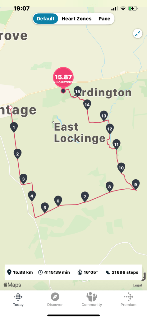
As I got to the Millennium Stones the sun was shining on them in a wonderful way BUT too much using my online OS app plus Fitbit and photos had used my battery – nothing left at all.
The route map shows where the battery ceased, so I had to measure the remaining section manually. Therefore I didn’t finish the walk in the middle of a wood but back at my house. The total for this walk was 18.3km. A great walk in the sunshine which I really enjoyed.