Second day of the Oxfordshire Way and we had agreed to start a little earlier. The day started with a message from the fourth participant to say that she needed another day to recover from day 1. So Annie, Anna and myself we taken to Ascot under Wychwood to start our route. A grey and damp atmosphere as we leave the village and quickly pass a Manor House and the site of a castle.
Over a bridge and off across fields again, quite muddy as we found on the previous day. The railway line curves round to Charlbury north of the Wychwood Forest and Cornbury Park. The River Evenlode meanders north of this line with our path north of that.
We continue on our way following a track which led into Charlbury- by this time we were beginning to think it was time for lunch but it was rather damp. As luck would have it we spied a bus shelter so we at least kept our sandwiches dry! Out of the village and along a track – not quite so muddy.
As we approach Hill Barn Farm Cottages there is a clump of trees to the right which look to have been landscaped. The colour of the leaves on the ground also catch the eye.
The weather although damp at times had not been too difficult so far even though we knew there was the threat of Storm Barra. The path led into and through Stonesfield and dropped due south. The landscape is undulating and extreme in this area and goes back towards the river. However instead of crossing the path turns abruptly to the left through Bagg’s Bottom.
The path is very straight and does follow the Roman Akeman Street at this point. A Roman Villa is marked on the map but no signs. Sadly the weather began to deteriorate at about this point, with rain increasing and the wind developing. We cross the road to Combe, and then have to climb steps over an estate wall which surrounds Blenheim Park.
We cross through a wooded area before the landscape opens out and we ‘fight’ our way towards the avenue of trees that lead down to the Palace. Fighting against the strength of the wind the visibility is really poor. The monument which should have been clearly visible was a hazy image. We all felt a bit low and agreed that a bit of refuelling was needed. So sheltering under a tree – well sheltering is a bit of an exaggeration- we all eat something before setting off again.
We find the wall again and the gate that leads through a community orchard and onto the A44. This is opposite a road junction and we cross onto a minor metalled road – no mud. The weather eases and as the day before the light begins to change just before 15.00 with a sunset visible.
Down a hill to the River Glyme and then back up again before a straight forward walk down to Sturdy’s Castle and our lift home.
We had walked well together and covered 20.8 kilometres – so a bit more ticked off!
A walk from home today and one that I had done before at the beginning of my original challenge.
This walk was delayed twice but eventually Becky (my ex assistant head and co head – one day a week) managed to coordinate a time for a walk. We walked a route we had done together before but last time it was with me limping !
So along the track to ‘not conker alley‘ and round through Lockinge, passed the church and out behind Ardington House.
We took the longer way back into Ardington so that we could stop at the shop and cafe. Hot chocolate with extra cream and marshmallows seemed appropriate for the day!
We took the route up to the stones, something I hadn’t previously managed with Becky. We’d been talking so much I realised I’d not taken any photos.
The stones are really difficult to capture ! As we came back down the hill on the wide track in the woods the sky started looking interesting.
Nearly home – great walk, great chat. So easy to solve so many issues with education when you are out for a walk! One day the DfE will catch up with our thoughts and stop failing children!! Until then more walks to be done.
So a whole week of walking – the Oxfordshire Way, all 67.5 miles of it over 5 days- 108.6 km . Organised by SPR so transport to the start of each day was included and pick up at the end of each days walk. Every day had a very different structure and grouping so each day will count as a separate walk.
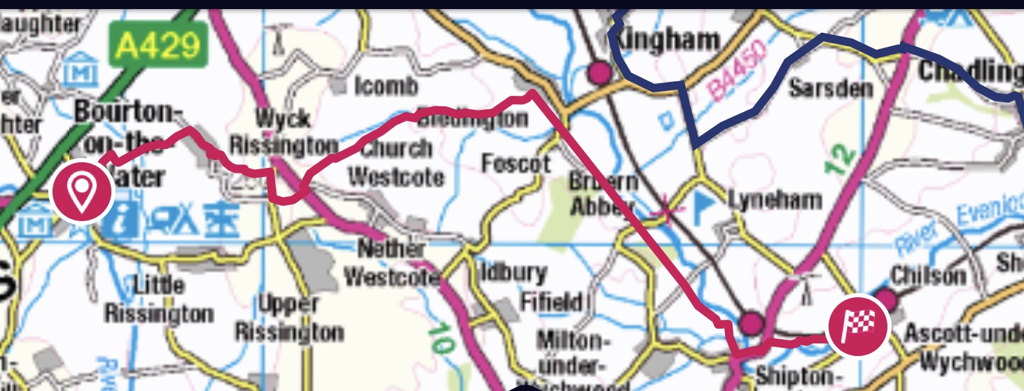
So Day 1 – Monday- started with a trip to Bourton on Water. This is on the tourist route for visitors to the Cotswolds and boasts a model village, perfume factory, a car museum and the River Windrush running through habitation with quaint, picturesque bridges crossing at several points. It is in fact a Roman Settlement and is nestled next to a Roman Road – Fosse Way.
This large village was sometimes visited as part of a residential visit to Stow on the Wold – usually with Year 3 and sometimes Year 4 children( 7-9 year olds) . A great area to visit. 
We started the week with a reasonable sized group- Annie leading, plus myself, Anna and Andy, Jennie , Sheila and Richard. Not everyone was planning to complete the whole week but even those plans changed! The day had been advertised as a 10 mile walk which had left me wondering how long the other days would be?
We set off from the car park in the village and quickly made our way across fields and down tracks. Crossing a stream we stopped to admire the craftsmanship of this barrier/ dam.
It wasn’t long before we added drizzly rain to the rather slippery mud under foot and this persisted for a while. We met with civilisation quite quickly in the form of Wyck Rissington a beautiful little village straddling the road with picturesque houses and intriguing doorways! The Cotswold stone is always pleasing to see and evokes a past time. A village like this could easily be in a time warp.
The path took us across more fields, across the A424 to Stow on the Wold and then through a short section of wood before we met the village of Bledington. We were all hungry and the rain had stopped for a bit so the benches in the church graveyard seemed quite inviting!
Trees in the skeletal form can often be quite exciting!
The church was quite big and had impressive clerestory windows, possible added in times of affluence due to the sheep trade.
The weather had certainly improved and once refuelled we set off again passed Breun Abbey and keeping the railway line on our left. This is the route between Oxford and Hereford and provides a valuable commuter service to villages on route.
It was quite warm for a short while this afternoon and I ventured to remove my coat- I hate being overheated when walking- not for too long as there were a couple more showery moments.
The light started to change significantly by about 2.45 pm and this was the first of some spectacular skies – plus looking in the other direction!
We came out into Shipton under Wychwood. This was once the area of the Wychwood Forest another great royal hunting forest. Now sadly diminished. Having walked for half a kilometre along the busy A361 we decided not to go up hill to the station but to take a path off to the right which would soon remeet with the signed way. The GPS on my Ordanance Survey map app proved useful for this non existent/ underused path. By now the light was amazing and we were almost at our destination – Ascot under Wychwood.
So not 10 miles but 11.6 – so at least a little more ticked off ! A good days walking with pleasant company.
I really needed to go for a walk on this cold but dry day. I’d thought I was going out on the previous Wednesday but my friend got held up at work and by the time I knew, it was too dark to set off. Then my walk in the Shropshire Hills was cancelled on the Saturday due to high winds. Today nearly didn’t happen as I was waiting for a log delivery! Just decided I had to go! Worked out a route which should last about two hours and was from home.
So up the hill, beautifully clear and quite sharp, the trick of wearing gloves but not a coat seemed to be working. I was surprised how much ice there was on the puddles, so a bit of zigzagging these was needed.
Met a few people on this stretch, realised I’d forgotten to change my camera case over which was a bit annoying. So much easier, when wearing it round your neck. The sky over the ridgeway looked quite intriguing.
My route was straightforward and one I’d taken before, turning left as Larkhill met the road to Newbury and then right and parallel to some gallops and the point to point course. At the bottom of the field, and the last push up to the Ridgeway, I turned left instead of heading upwards. Somehow I had never done this route before. After a short stretch of open path it went through a small copse.
Not many leaves left on the trees but still a little crunch on the ground! A spot of colour really stood out.
This path which I enjoyed very much eventually met a track leading down from the ridgeway and I turned left on to it for my walk back down towards Lockinge. Just as I was contemplating negotiating a very large puddle I noticed a parallel path in the trees and decided to take that. Some great views over to the right- so lucky to live in such a beautiful area.
A bit further along and before any farm buildings I noticed a small wooded area to my left – old quarry ? It looked too extreme a dip to be natural and I noticed that there were brick remains – in quite good condition. Interestingly nothing marked on the map, even though there are quite a few ‘pits’ indicated in this vicinity. My guess is old lime kilns. I really must try to find out. 
I continued on passed a large barn and then was stopped in my tracks by a shout of “Is that you Marion?” and turned round to see two friends Libby and David, behind me. They had replicated my route and had both just decided the person in front of them must be me!
So no more photos but great to catch up and chat on our way on this very straight route back to the village and the statue of ‘Best Mate’.
I’d never walked this path before but had driven as far as the farm house where a good friend of Alex’s lived when they were at school. Picked up and dropped off a few times and been to a joint 18th birthday party. Alex often calls in here on one of his run routes when at home.
We all discussed how wrong ‘non- conker alley’ now looks and they branched off at the end of the track back to home.
I’d suggested I’d be back by 3.15 and arrived at about 10 past and logs duly arrived at 3.15 ! I forgot to set any of the trackers until I ‘d got up the hill to the reservoir but almost exactly 10 km. So glad I went out- got a bit cool at the end but I was walking quickly enough to never need the coat!
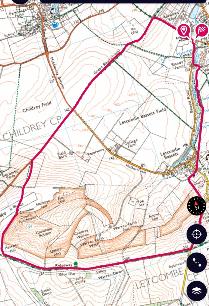
A walk today by myself and closer to home. I parked in the village hall car park at Letcombe Regis but I was aiming for the neighbouring village of Letcombe Bassett. Both Norman names.
After a short distance in the village the path turns sharply left and up some steps. This area has been revitalised and there are new information boards. The path runs parallel to the road and Letcombe Brook can be seen below.
This area of the brook has many springs originating from the chalk and once was an area renowned for growing watercress. There is still some colour on the trees but many leaves are now on the ground. The path emerges in the village of Letcombe Bassett and my route goes towards the church.
Ledecumbe”, comes from the “lede in the combe” or “the brook in the valley”, referring to the Letcombe Brook, whose source is in Letcombe Bassett. “Bassett” comes from Richard Bassett, who held the manor in 1158.
Letcombe Bassett is the village of Cresscombe in Thomas Hardy’s novel Jude the obscure. Arabella’s Cottage, where Jude met Arabella, still stands.
The path runs steeply up hill and then alongside a field before meeting up with Gramp’s Hill and on to the Ridgeway. Over to my right is a wonderful area of undulation, marked as Crowhole Bottom and Devil’s Punchbowl – another one !
The ridgeway runs along the edge of this area. Towards the end of the undulation Hackpen Hill starts and a footpath is marked on the map to head round the rim of this basin. Not marked on the ground but sure of where I am I still set off to a fence corner. No stile but climbable and still sure I was in the right spot.
The track ran north east between a mound and a tumulus – so many ancient earth works in this area. The site of the stile is obvious but not really there,! Another fence to climb and avoid the barbed wire! The next stile is even worse and I have to wedge the loose top step against the broken and fallen bottom step to be able to get over- even more barbed wire. Not impressed!
When I reach the road to Lambourn I was met with another non stile and a deep sloping ditch – having to risk whatever was at the bottom I had to head down to the road and the very clear footpath sign pointing to the ‘stile’.
About a kilometre along the road and then across to a Green Road. Looking back there are two groups of trees on part of Hackpen Hill, these are thought to have been planted by Lord Wantage to replicate regiments of soldiers.
After a couple more kilometres a distinct crossroads appears. The path leads directly down to the side of the village hall and my car. A good stretch out today with some definite climbs and about 10 Kms.
Another SPR Expedition – this time with a difference – an evening walk in the New Forest. So meeting at Millets Farm at 16.30 to set off . Steve plus six of us walking today.
We parked by the Royal Oak at Fritham and by the time a couple of people had used the toilet at the back of the pub we set off at 18.30. We started along a track and then turned to the south west and proceeded by pacing 1000 metres. Really pleased that my 70 double paces per 100 metres is still accurate.
A turn off to the right and into the forest and along a wide fire break track. The path was muddy in places but not too bad. We had seen two deer just as we were reaching our parking place but only eyes amongst the trees at this point.
An abrupt turn to the north west and a surprise adventure! Latchmore Brook needed to be crossed, a deep brackish strip of water – a bridge would have been far too easy! Instead a fallen tree, double trunk – well Steve walked across – this was about 6 foot or more above the water. My method involved crawling along the widest trunk and then having to lower myself down, sliding down my front. Well I survived!
A bit more wood and then out on to open land on the ridge above Alderhill Inclosure. Unfortunately it was a rather cloudy night which is a pity as it was a full moon – a beaver moon. Apparently called this as it marked the time when native Americans set their beaver traps. After about two kilometres we turn back into the wood.
Boggy on this stretch and Steve is the first to slip over, real care is needed. We’re going almost east now and into the depths of the forest – more eyes! Then to turn north for a kilometre before the next exciting experience!
Two members of the group had been doing navigation training and we were going to do a section off of the path and just through the forest- roots, fallen logs, branches and bogs!
Steve and Debbie set off on a bearing until they were told to stop and adjust their position by Annie and Maddie, then we all walked to meet up as a group again. Well not too far before we have some water – just a bit of a ditch – until one of the others said I’m stuck, sinking !
We’d hit a bog. The first two had got through, I was okay and gave the stuck person a hand , another member of the group tried to help from the other side and sunk herself. Not sure how I managed it but I remained unscathed apart from aching the next day where I’d pulled the two of them out of the bog!
Okay for a while but now accompanied by owl hoots – sadly none were spotted. Another deep ditch with a stream at the bottom, short diversion and a slide down one bank some quick stepping on rocks to minimise soaking feet and then a scramble and helping hand up the next bank. Some good team work developing within the group. Onward through the forest and the head torch which has been very bright runs out! Thank goodness for phone torches.
The only photo I managed to take having climbed over a tree trunk – an amazing bract fungus.
The next stream has a bridge and we come out by a small lake and the eyes turn into actual moving deer. They run parallel to us and we are able to watch for several minutes. Not long and we follow a metalled track back to the minibus. It’s now about 22.20.
Several people get into the bus with very soggy feet and rather muddier than when they started out. A good journey back and back home by 00.05!
Forgot to turn both apps off straight away so the route goes by the lake and track back to the start. I also realise that the OS map shows distance but doesn’t allow for height gains and lost. So by the OS the route was 12 km but by the Fitbit 17km.
The first walk with SPR expeditions for a while. Having arrived at Millets Farm at 8am I discovered there was a slight change of plan – not a section of the Mid Wilts Way but a circular walk starting at Avebury. Steve the leader had been called away on a family issue and Annie had been asked to lead at the last moment – she felt she needed to do something she knew especially as she was also driving the van.
Four of us, plus Annie today. First to cross the road away from the car park towards Silbury Hill -a prehistoric man made chalk mound – the tallest in Europe and part of the Stonehenge, Avebury UNESCO World Heritage site. We are not diverting to visit today – you can no longer climb this monument.
Our path turned to the left and skirted under the West Kennet Long Barrow and we are following the White Horse Trail, which crosses a couple of tracks and follows the ridge of the hill gently upwards.
The path continues until it meets a path along Wansdyke a large earthwork. This is now part of the Mid Wilts Way.
The dyke was found to be post Roman and possibly built as part of a defence strategy during one of two Saxon wars which were held due to invasions into the area.
The path turned and led down a very straight track along the spur of the hill down to Beckhampton, a village with some attractive houses. Once through the village we had an interesting section of road work around a round about and towards Avebury. The path is alongside a field featuring two large stones – named Long Stones on the map and called Adam and Eve on the information board. These were the two starting/ final stones of an Avenue that led to the stone circle.
We emerge into the village and walk through the stones which are now dissected by a couple of roads. This is a complex site with circles within a circle and one of the largest sites in Europe. The village also has a Manor and garden, which we didn’t visit but a dovecote could be seen in the farm courtyard and we did partake of tea in the NT cafe.
The walk today was quite straightforward and a bit grey, slightly damp but not actually raining. It was about 17.5 km and we all felt quite achy at the end, having kept up a good pace.
I took a while to decide where to walk today, not really wanting to drive too far but needing somewhere new. After a bit of map gazing I decided to walk from Fawley – a small village off of the road between Wantage and Hungerford.
A bit of a struggle to park in the village but eventually managed and usefully clocked the path that I hoped to take for my return. Firstly the path went passed the church – quite a sweet building, it has a semicircular apse at the rear which I didn’t manage to capture.
The path took a distinct turn and headed towards the Ridgeway. Having started my walk just over the County border into Berkshire, I would soon return to Oxfordshire.
The path was on slightly higher ground and there were fine views of undulating ground and very distinct copse. This one was called ‘The Beeches’ the path is a very distinct green track, well defined, very straight and I suspect quite ancient. Some muddy and wet areas to negotiate.
The distinct line of the ancient road soon appears and as I stop to eat I feel slightly guilty that having passed the head of this track on many occasions with groups of children I had never noticed it before.
Only about 220 metres further on I can see the distinct stile where I have emerged with children having walked from Wantage via Letcombe Regis. Another 200 metres and my route turns back south west away from the Ridgeway. The space on this side is vast and habitation is so sparse. The path curves round and meets one going due south at a crossroads.
Could these be old driving roads connecting the Cotswolds to the South Coast – sheep and wool were such important commodities in the past. The wool from this part of England was often exported to The Low Countries – Belgium and Holland to be used in the production of tapestries and fine cloth.
As I’m contemplating this idea I see sheep in a field and hear cows – two large fields of them. Studying the map on return I see Warren Farm ( Beef testing centre) – I wonder if it still is and what that entails?
Also marked on the map are field systems – I was expecting to see distinct strips but instead …
Anther very distinct crossroads and I make more or less a 90 degree turn to the east. The path continues this way until it becomes a metalled road entering South Fawley.
By now it is beginning to get quite dull and it has gone past the predicted sunset time – difficult to tell the difference! My route which has been on tracks now changes to a path across fields – this is the one I had spotted earlier. It doesn’t look as dark in this shot as it was beginning to feel.
The path did diminish a bit but it was always there and lights indicated I was heading in the right direction. Trickier as I neared the village as it went through a copse and cut the light even more. One of those twilight times when a torch doesn’t really help. I emerged where I had expected and back to the car.
Really glad I made the effort this afternoon. Just over 12 km. The cloudy mizzle did turn to rain at the highest point on the way back but almost by the time I’d put on my jacket it had stopped! Quite warm though for November.
My walk today started just over the border in West Sussex – the county where I grew up before coming to Oxfordshire for college. I parked behind the shops at Fernhurst in a free car park – thank you Chichester District Council. After a short walk through the village I turned left down towards Hawksford Farm which I think may well have been a stud farm or similar. Although this area is much more Sandy and moorland like than my part of Oxfordshire the proximity to the South Downs is very similar to the Ridgeway and horses seem to occur regularly in both areas!
My route continued southward alongside a stream, across open land and through woods. A great mix of trees. It has been documented before that I’m not particularly fond of walking through fields with horses so not too enthusiastic on crossing an open space to see two horses by the exit corner. I’m in luck though someone is with them – he helpfully tries to move them away only to have the effect that they are now bucking and cajoling each other – but far enough away that I managed to exit the field! !
Along a small track and I need to cross the A286, the path skirts the other side of this far enough away to hear but not see vehicles. After a steep climb out onto the road edge it’s back across and up a track where there has been extensive deforestation / management. Looking back I suspect this is Blackdown in the distance – Walk 2.
The path climbs up quite steeply and I emerge on the top of the escarpment. Across more open land until I find another track which eventually leads to the view point over Woolbeding Common. For the last few kilometres I have been following the Serpent Way.
As I look out from the view point I’m reminded about Walk 3 from Woolbeding Bridge and along the River Rother and my visit to Woolbeding Gardens the same afternoon.
Another memory from much longer ago is evoked as I look out. A fifteen / sixteen year old me camping at Stedham which is down in the valley below, with my Guide Company. One night we had the most almighty thunder and lightning and being in charge of a patrol of hysterical younger girls was not much fun. Probably not a logical thought but I remember trying to move away from the pole in our large Icelandic tent just in case the lightning struck the metal at the top! I also remembering advising one person that no this was not a good time to go to the lat tents!! We did walk to the top of a hill at dawn – we were all awake – and watched as the storm continued to circulate.
Trying to find the summit of Older Hill proved difficult and boggy. I was very close to the top but really not sure where the top actually was! Having taken a somewhat circular route in this area my path then started going eastward – back on Serpents Way.
At a major intersection I met a fellow Walker and he asked if I was on the ‘ New Lipchis Way’, I explained that I wasn’t and showed him my route. I had been using the 1:25000 version in my app. Looking later at the 1:5000 version it appears I had been following it and was about to head that way.
Rather randomly whilst talking to him I discovered he lived in the road in Petworth where I had grown up from the age of 7 ( originally all police houses) and that he had know my dad.
My route continued through the wood having turned north as I wanted to go passed the end of Furnace Pond. This path was close to a stream and was very wet and slippery with some steep down hill sections – the walking pole I had been carrying came in useful at last. Amazing suction some of that sandy mud has!
As I appeared onto a metalled path and turned right for a short while before meeting a junction of paths, my luck slightly ran out – the route I needed had two horses right by the style. Deep breath and went for it – only about six horses in this field – taken from a safe distance.
Through the wood again and just before the pond my way was barred by Harris Fencing. Instead of the tranquility and bird song if the woods there were diggers, piles of mud and sounds of. Machinery. Not much chance of seeing any deer – I ‘d found lots of prints in this part of the wood.
The pond is significant as it forms part of the site of Fernhurst Foundry which produces iron for armoury in the 17th and 18th century. It is a scheduled site and is currently undergoing some maintenance work. https://historicengland.org.uk/listing/the-list/list-entry/1021403
I was left with no choice but to take an alternative path which would take me back to Fernhurst but not really the way I wanted to go. I set off and then found an temporary arrow indicating a permitted path – I realised this was the alternative route I had been told about. A temporary bridge over the stream and eventually back on my original path choice – pity I had wanted to look at the pond again. Another time!
I came out on the main road by some Cottages, possible part off High Building Farm. It was too soon to curtail my walk by just returning to the village so I turned away and along the road to the left before I could cut up north. I started walking parallel to the road and then checking my map realised I could go even higher and back up into the woods again.
Having been walking most of the day in a long sleeved tee shirt I did put my fleece back on but the weather was still splendid and the colour in the trees continued to be a joy. The path eventually joined the minor road from Marley Heights and down passed Van Common – back to the road and a short walk back to the car.
The light was beginning to fade even on this bright day and there was a wonderful reflection of the setting sun on the buildings above the shops as I reached the car park.
Nearly 19.5 kilometres today – lots of up and down, some tricky wet paths, one real bog, several places calling for careful foot placing but a warm glorious day – thoroughly enjoyed.
Today’s walk started in a very different venue, Hindhead in the south of Surrey. I had driven passed the turning for “The Devil’s Punchbowl’ many times on the way to see my mum but this time I stopped.
I was starting the walk perhaps a little late in the day, one which was forecast as cloudy – murky would have been a better description! I decided to stay on a high path rather than to drop down into the valley.
I first walked northward and then down a steep diagonal path. Quite a lot of colour still in the trees but not much to see in the actual bowl.
The path then cut across to Highcombe Farm and followed a well defined path. Turning south the route followed the old Turnpike Road between London and Portsmouth. I became an impromptu photographer for a group of four and then made my way towards Gibbet Hill.
Below the road near the top of the escarpment was a track which I came to realise was the replacement road built before the newer A3 with it’s tunnel under Hinhead Common. I wondered if I had ever travelled this way many years ago?
The viewpoint at Gibbet’s Hill did not really live up to it’s purpose today but there was a board telling of highway men being hung at this point as a warning to others.
I should have gone SSW from here but managed to swing round and found myself too soon heading for the car park. Luckily there was an alternative and I was able to double back diagonally to reach my intended route, crossing the Greensand Way and continuing until the track met a road at the Royal School.
A little further along here until I found a path cutting up to the right and back to my starting place.
This was a great walk of about 7.5 km and I was left wishing to go back and see more!