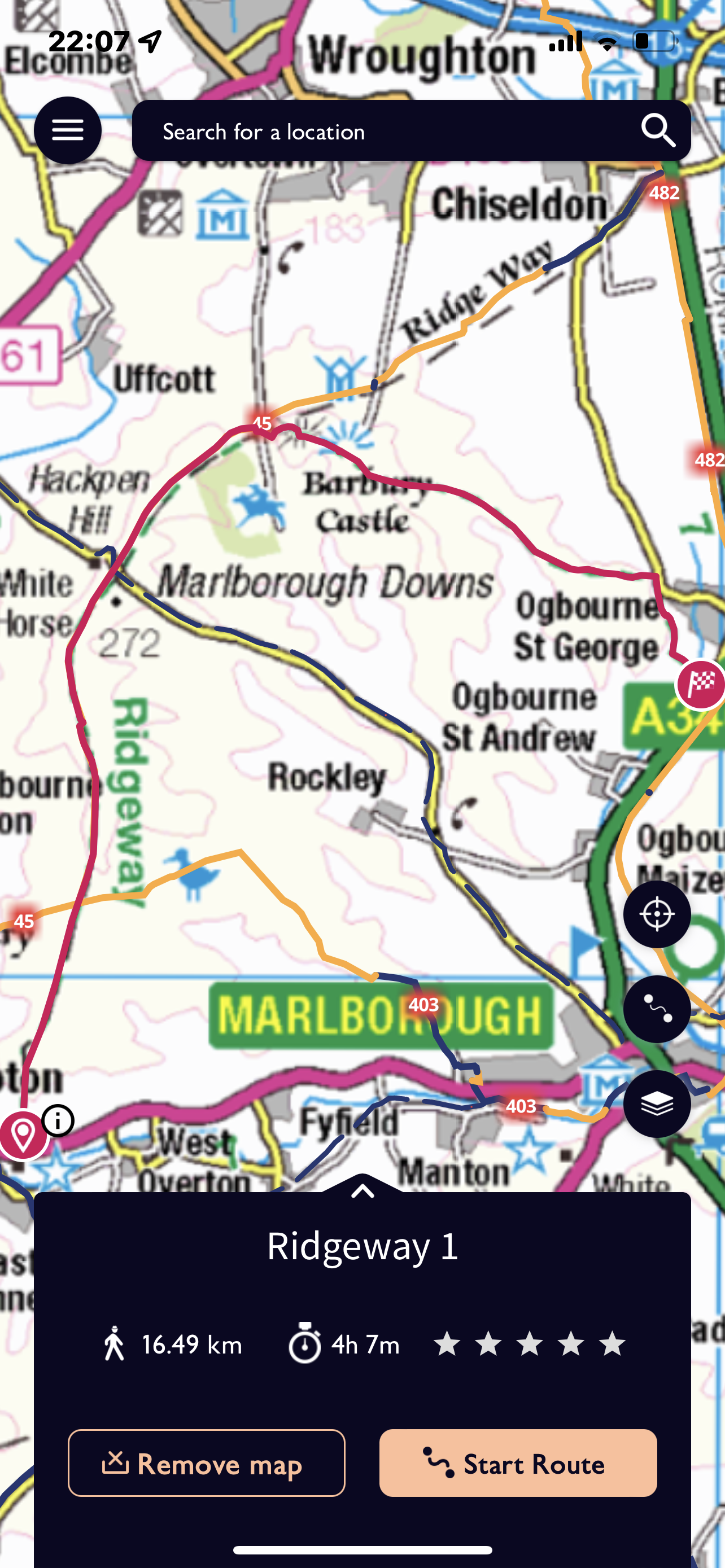
So today is the start of a seven day adventure / challenge walking the entire length of the Ridgeway, an ancient roadway – 87 miles / 140 kilometres.
Again walking with an SPR group which has the distinct advantage of transport to the starting point and collection from the finishing point plus your own bed for the night!
As I meet at Millets Farm at 08.00 on a Saturday morning I discover we are quite a small group for this first day. Steve will lead but there are only three in the core group that hope to complete each stage – that’s Anna, Mirella and myself.
Not the best of weather forecasts but it is January. The walk starts near Avebury on Overton Hill. This is the start of 87 miles!
The path is very obvious and continues northwards towards Hackpen Hill – strange that there is an area nearer Wantage with the same name.
The weather is not being too kind but rain is quite light – well it was !
Onwards passed some cows and wonderful clumps of trees.
The path eventually turns to the East and we can begin to see Barbury Castle – an Iron Age Hillfort. By now the rain is harder as the forecast has threatened.
The Hill fort has double ramparts and a very deep ditch – amazing to think this would have been dug out with antlers! Steve decided that we should walk around the ramparts rather than through the middle where the path went and that we should get out the shelter. So we sat in the most exposed place inside an orange shelter , each sitting to hold down an edge and using our rucksacks as extra ballast !
This was suppose to make a more comfortable lunch break – I would have to agree to disagree! I had the wind blowing on my back and shelter flapping round my hood making it hard to drink my coffee.
Having emerged from our lunchtime ‘accommodation’ we continued in a ESE direction and along a completely different area – Smeathe’s Ridge- wide and grassy and then sun was trying to break through. We are again in an area used for horse training.
Some rather beautiful grass to walk on, we go along this ridge and then down towards Ogbourne St George but not through it. We cross the River Og – not very significant at this point and walk through the hamlet of Southend before reaching the main road between Swindon and Marlborough. Interesting to see the various building materials used for houses. Chalk always seems an unlikely building material.
The walk today was 15 km and quite tough at times due to the weather.
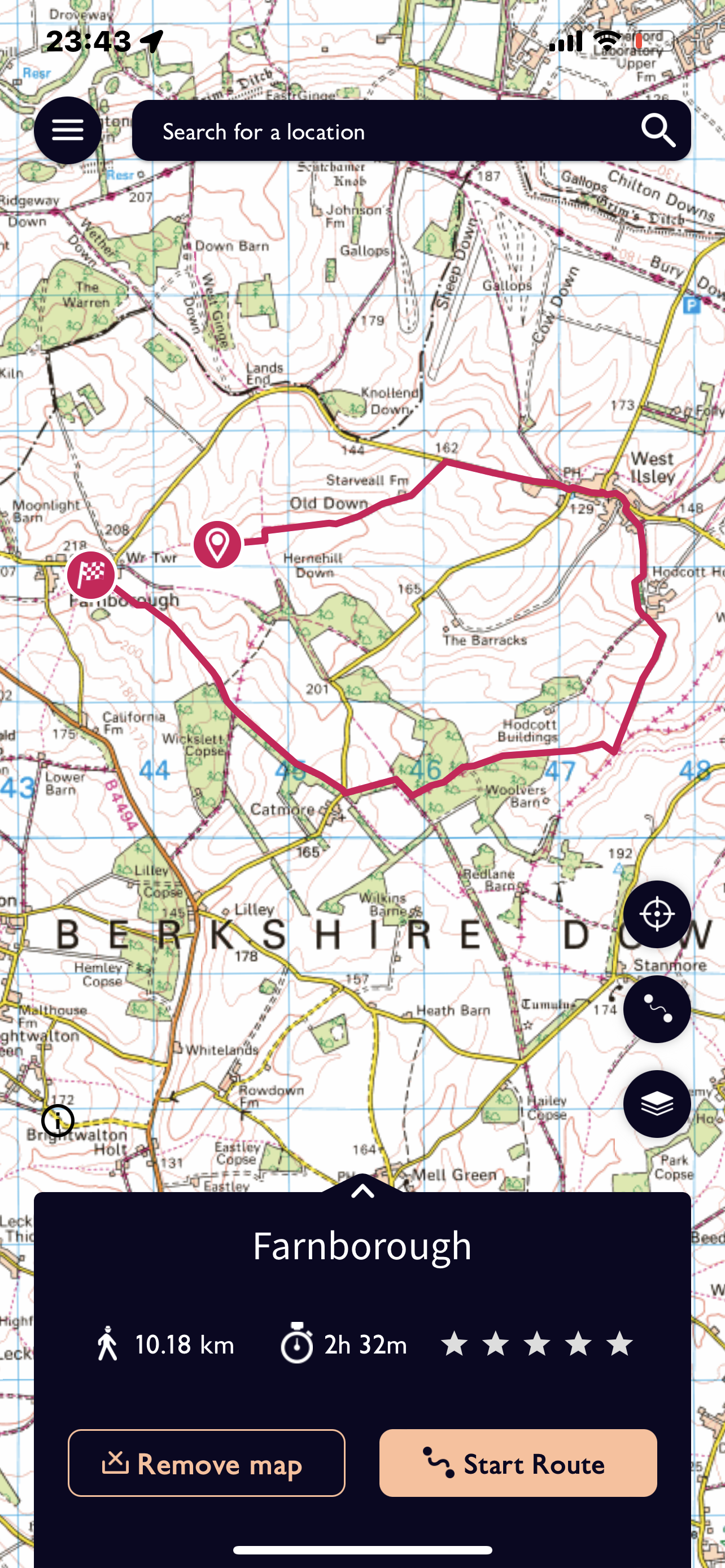
A walk by myself again and starting just a short drive from home. After a bit of map searching I decided to drive to Farnborough which is just off the the B road to Newbury. A village with some attractive housing which I have driven through before on my way to West Ilsley which was to be part of my destination in a ‘circular’ walk.
Firstly where to park and luckily as I drive past a lay-by next to the church there is a couple removing there walking boots – a quick turn around in a farm entrance and I lurk until they are ready to leave and I can take their slot.
Back up the road to the farm and then off across a huge open field with a very obvious muddy path.
At the rise of the hill the path meets a very obvious track which on the map is called ‘Old Street’ – a quick dog leg with a left turn and then to the right across more fields. The view as in so many of these areas is vast. The track skirts Starveall Farm which has been very well refurbished and a track leads to the Farnborough to West Ilsley road with a track alongside.
After a short while the road enters the village of West Ilsley, a linear development. There is a pub next to the road called ‘The Harrow’ which overlooks the sports ground. Reknowned for it’s siting and views of cricket matches.
It looks like an ideal venue for multi sports – football nets with rugby goals on top next to the cricket square!
An idyllic setting of a duck pond was a good place to stop to eat before walking past the church – noticeable for its flint.
A track leads off from the village towards a very distinct area which accommodates the very large West Ilsley Stables. This follows the Berkshire Circular Route and eventually joins with the ‘Downland Villages Riding Route’ – that really shouldn’t be a surprise in this area. At least no fields containing horses so far today! The track ways are very much of the sunken path, high side style. I always wonder how old these are?
On the first section of track out of the village I saw two people approaching and thought I recognised them before I could see their faces. People have a really strong shape and gait identity. It was who I had thought and had a really great conversation with one of my ex teachers and her husband. They were the reason I used to visit the village – a great interlude but I was also aware that time was getting on. Rather a long way to go and quite a dull day!
A great track next to a wooded area and then through a section on a well defined path. A short section on ‘Old Street’ again before meeting a metalled road junction. Much of the last section had been on restricted byways – good fun in the right sort of vehicle! A slightly unnerving spate of gun shots and also several noisy pheasants taking off from the edge of the path. Not necessarily good for the nerves whilst travelling alone!
Another distinct but muddy track next to a thicket of trees along one side and then alongside a copse. Quite pleased that the last section approaching the village was in an open field, giving a little more visibility as the light was fading. Quite a long stretch up a wide spur of a hill before a very muddy patch as two paths intersected and a helpful stile was in sight. The very last stretch was in a field close to my car with the church appearing on the horizon.
To my right as I’m almost back is a splendid house which has a haha and the road between this village community area I’m crossing. A quick peak at the church before getting back in the car. Slightly lighter at 16.15 than a few weeks ago!
A good stretch out and an enjoyable walk. About 11.5 kilometres.
I have been walking the last few days but not a proper walk – I can’t count walking back from Boxing Day celebrations or returning to collect the car the next morning or visits to the post office! So time for a walk to finish the year.
I was going to drive but decided instead to walk from home but to try a slightly different route.
I forgot to start the Fitbit so have added on the 1/4 kilometre at the start to record 11.5 kilometres for this afternoon’s walk. It really is difficult to believe it can be so warm on the last day of the year. no coat just a new fleece and I did wear gloves but soon abandon those.
My usual route along the track, still shocked by the loss of the wonderful horse chestnuts and it is difficult to justify in my mind a wholesale felling. There are newly planted Lime trees to mark the Quern’s Platinum Celebration.
Through into Lockinge and up by the side of Henrietta Knight’s stable – I’m not sure whether I’ve ever been up this way, usually travel in the other direction. There is something very striking about the skeletal value of trees in winter as these are slightly bent by the prevailing wind.
At the end of this quite long and muddy track is the option to turn left and complete the top part of the walk before heading downwards to home. For some reason I feel compelled to continue up the last field and on to the Ridgeway. Evidence of cows all around but none in sight and at the gate onto the Ridgeway and it’s parking area the open gate hopefully just means they have been moved!
Quite pleased that I managed the killer hill with only one very short stop and a couple of hesitations! I still don’t understand how Alex runs up it!
Just a short venture along the Ridgeway today as in just over a week I will start my seven days of walking it’s full length! Did I really sign up to that! The monument comes into view- the red of the Cornus always adds a wonderful contrast.
Opposite is my footpath marker and down across a muddy, flinty field – but it is down, having done a lot of up since I left the house.
This joins a farm track which runs parallel to a strip of woodland with a very distinct path so an obvious choice! A long stretch down hill and I can stride out – well carefully so as not to trip on roots. I see several squirrels in this section – I thought they hibernated – perhaps not or just too mild.
This eventually becomes a track and passes Bitham Farm and out into Lockinge and back to home. The light is beginning to fade and there are some pretty clouds.
I realised that this is the first time I had walked by myself since walk 18 of this block which seems a bit crazy really. Quite liked the solitude and the opportunity to be absorbed in one’s own thoughts.
My resolution for 2022 is not to get behind with my blogs. I felt quite stressed that circumstance had not provided an opportunity to write up the Oxfordshire Way until so long after the event. Each blog took a lot of looking at the map and photos and really concentrating to relive the walk. That mustn’t happen again.!
How ever much the intention is to go for a walk on Christmas Day in the daylight I rarely seem to achieve it. Not the most enticing of days in the drizzle but Alex and I decided to set off and walk around the edge of Wantage- at least there would be some street lights.
No photos or a route map but measuring on the map on our return we did walk 6.5 kilometres!
So down from the house, across at the round about and passed the school and along Charlton Village Road which slopes steeply down to the traffic lights. Across here and turning right towards Grove- we decided against cutting through an estate that can course you to get lost even in day light!
We turn left at the next roundabout and walk along Mably Way passed the entrance to the health centre. On to the next roundabout with the De Havilland Venom aircraft commemorating the long since abandoned Grove airfield we turn right along Denchworth Road.
This road has changed greatly in the last few years with another new estate fronting onto this road. The houses get increasingly older as we approach Camel Crossroads – another roundabout and we go straight across. – don’t think I’ve ever crossed the road on foot here before. although this is all familiar territory I’d never walked this exact route.
Going along Ham Road we are looking for the entrance to Lock’s Lane – much further along than I was anticipating. It looks rather dark but as we venture down it and approach the brook and the mill pond at the bottom with it’s ford we have our way lit by a useful street light.
Up from here, passed the old priory buildings long since converted to exclusive homes and out on to Priory Road. We go passed one of the back entrances to King Alfred’s school and Alex reminisces a little, as we come round to the front we can see newish fences and refurbished buildings – all changes in the last nine years.
Along Portway to the traffic lights- towns are so eerie and quiet on Christmas Day late afternoon! Across the staggered crossroads and in to Ormand Road, again another place of changes with new houses on the site of an old Girl’s private school and the now very established apartments in the old Engineering Works.
Alex decided we should walk through by Trinder Road and cut passed the Scout HQ – a place once visited quite frequently – now only for voting! More new houses on the site where one of the three secondary schools once stood. Amalgamated to make one school both boys spent a couple of years at this site which became the home of Year 7 and 8 , which at least stopped the whole thing from feeling to vast.
The trouble with coming this way is we can either turn left and drop down to Charlton Road which is a bit of a waste as we’ve just cut off a corner, or turn right and go up the hill. We of course go up the hill and along Larkdown – by now the drizzle really has turned to rain. Along this road and then left down Larkhill and home.
Good to be out to wear off some food and get some fresh air and to have a walk with my younger son!
A route more or less that I had done before but not included amongst these blogs. Starting with meeting at White Horse Hill Car Park. Due to Covid rates being very high in London Alex and Pete had decided not to swop between homes over Christmas so this was a meet up.
Not just with Pete however but also his parents and two small nieces. Luckily with proper carrying packs.
So diagonally across the field and up towards the white horse. The wind is blowing quite hard and it’s a bit slippery underfoot. Both girls seem to be coping. So we cross the top of the hill to walk part of the way around the embankments of the hill fort- even more strong wind. We exit at one of the ‘gateways’ and double back to get on to the Ridgeway.
At this point the path is almost sunken into a bit of a hollow and it gives us a bit of a respite. The decision has been made to walk to Waylands Smithy – not sure if anyone realised how far it was – not a great distance but not just round the corner.
Too busy chatting to take any photos but we did stop to watch a deer chasing round a field creating a strange route – they change direction very quickly.
Waylands Smithy is as magical as ever and we all walk around this burial ground which is quite possibly 5,500 years old. Pete is feeling a little tired from his carrying so Alex takes a turn!
Back the way we had come along the Ridgeway and instead of returning to the hill fort we cut back down the road to the car park. About 6 kilometres today but once we were out of the wind it was a good stretch and good to catch up with Pete and his family.
Another even earlier start today – Millets Farm for 06.00 – I’m very rarely up and driving for this time of the morning!
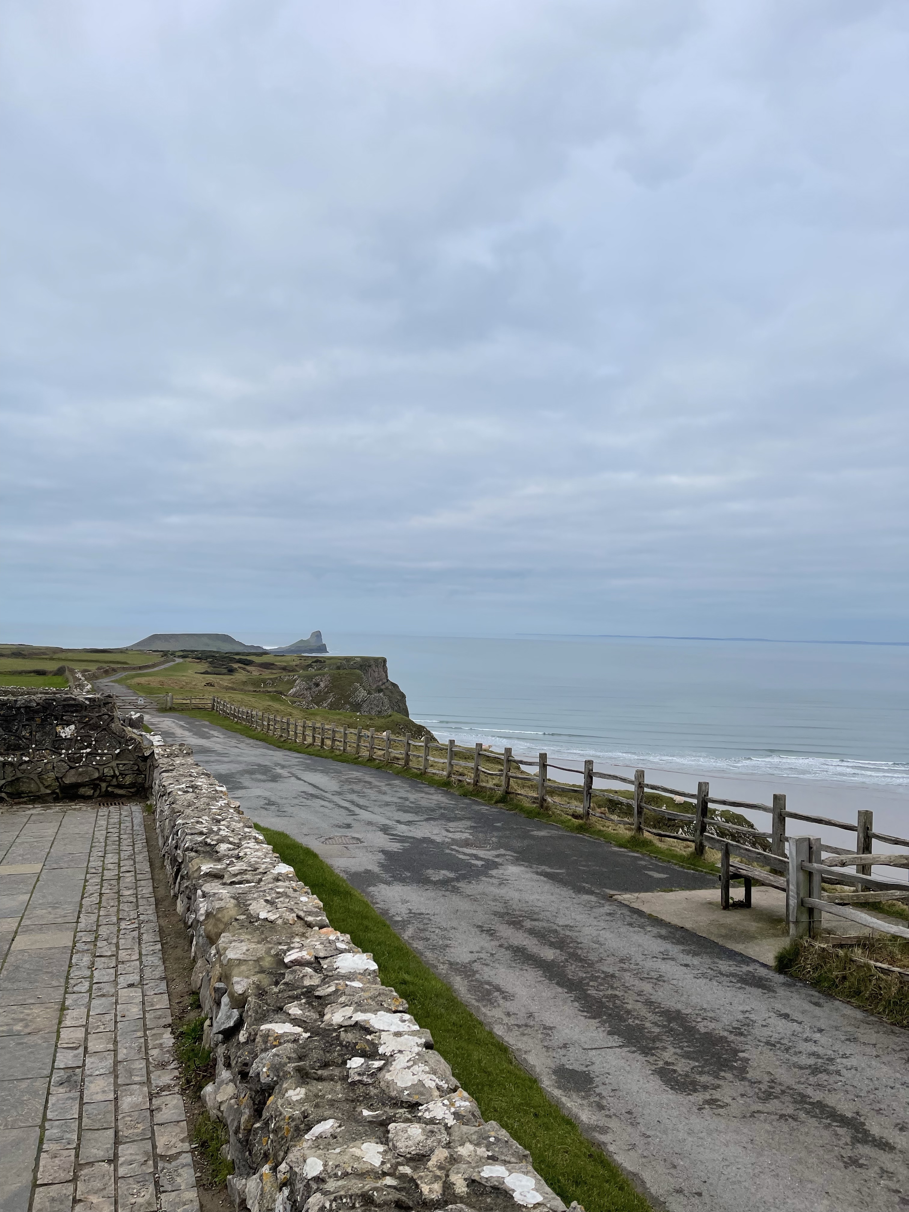
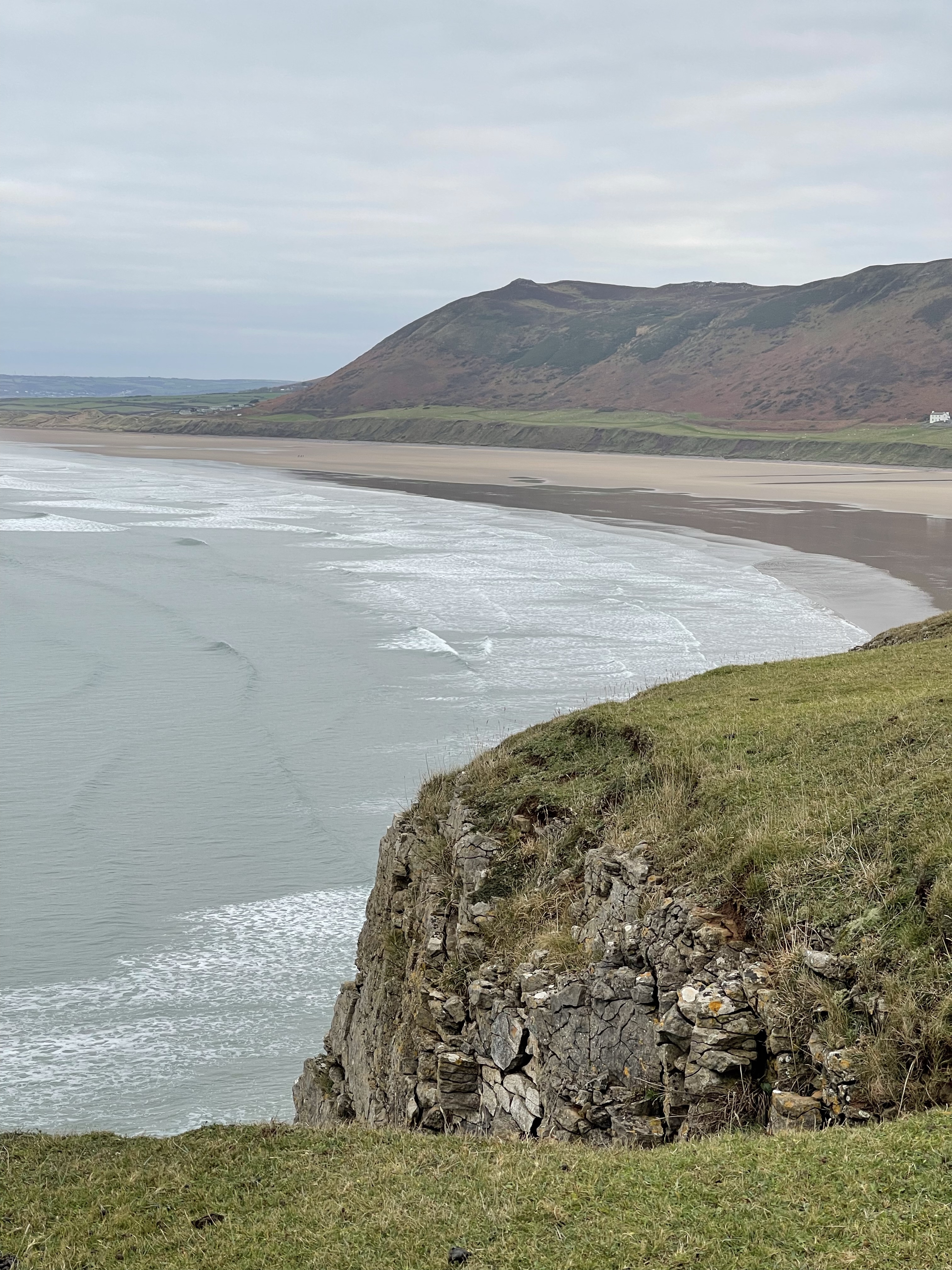
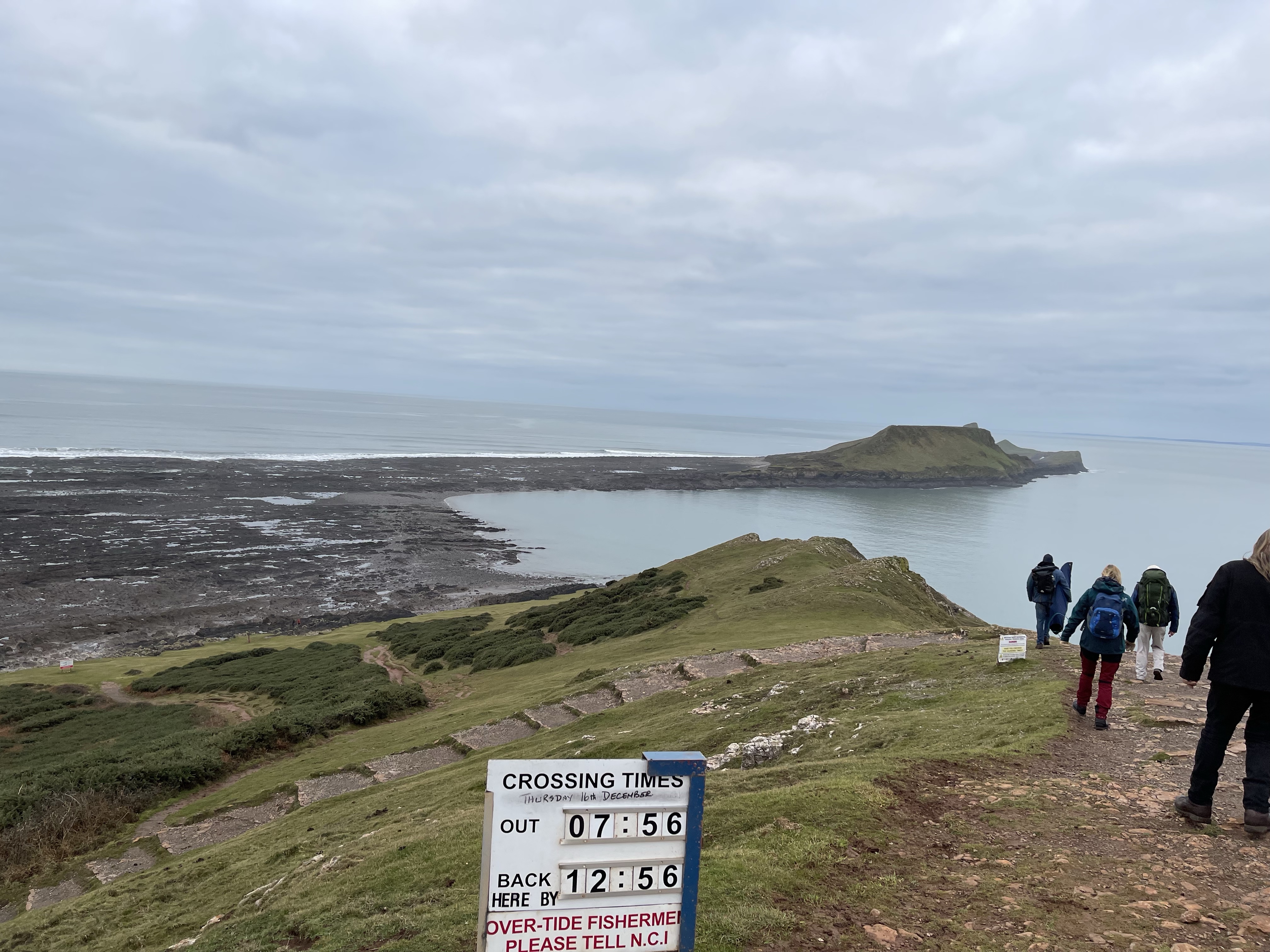
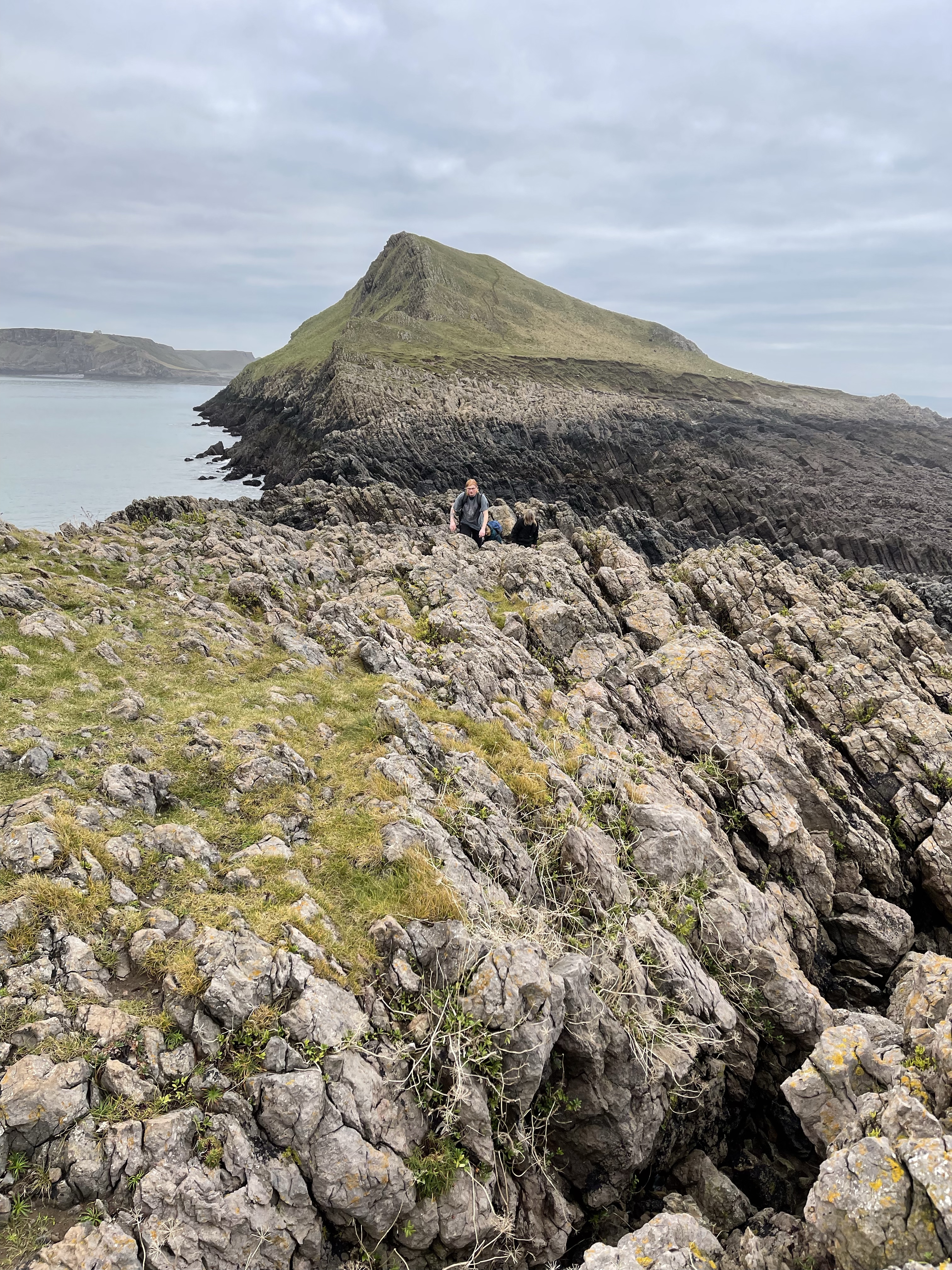
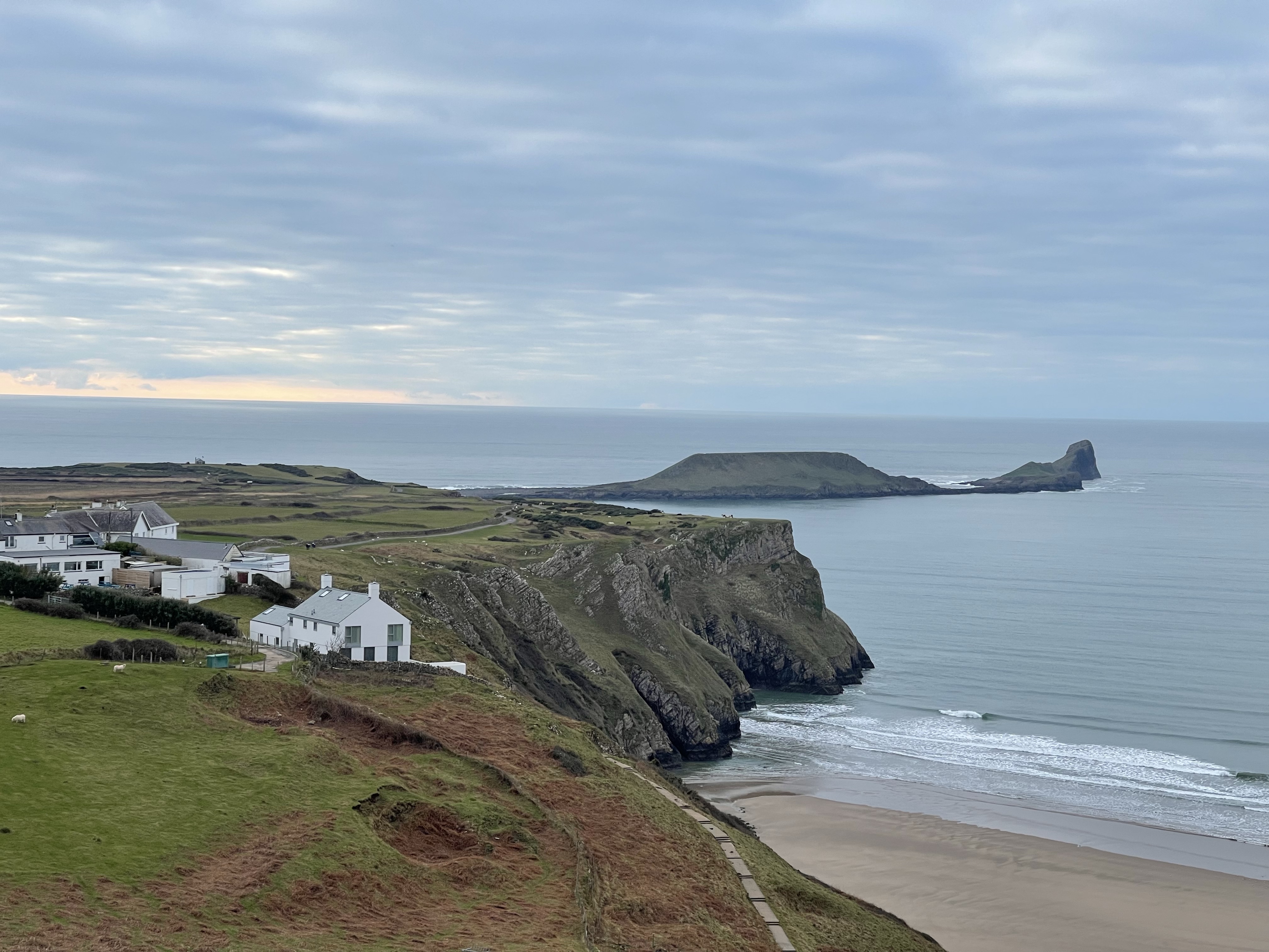
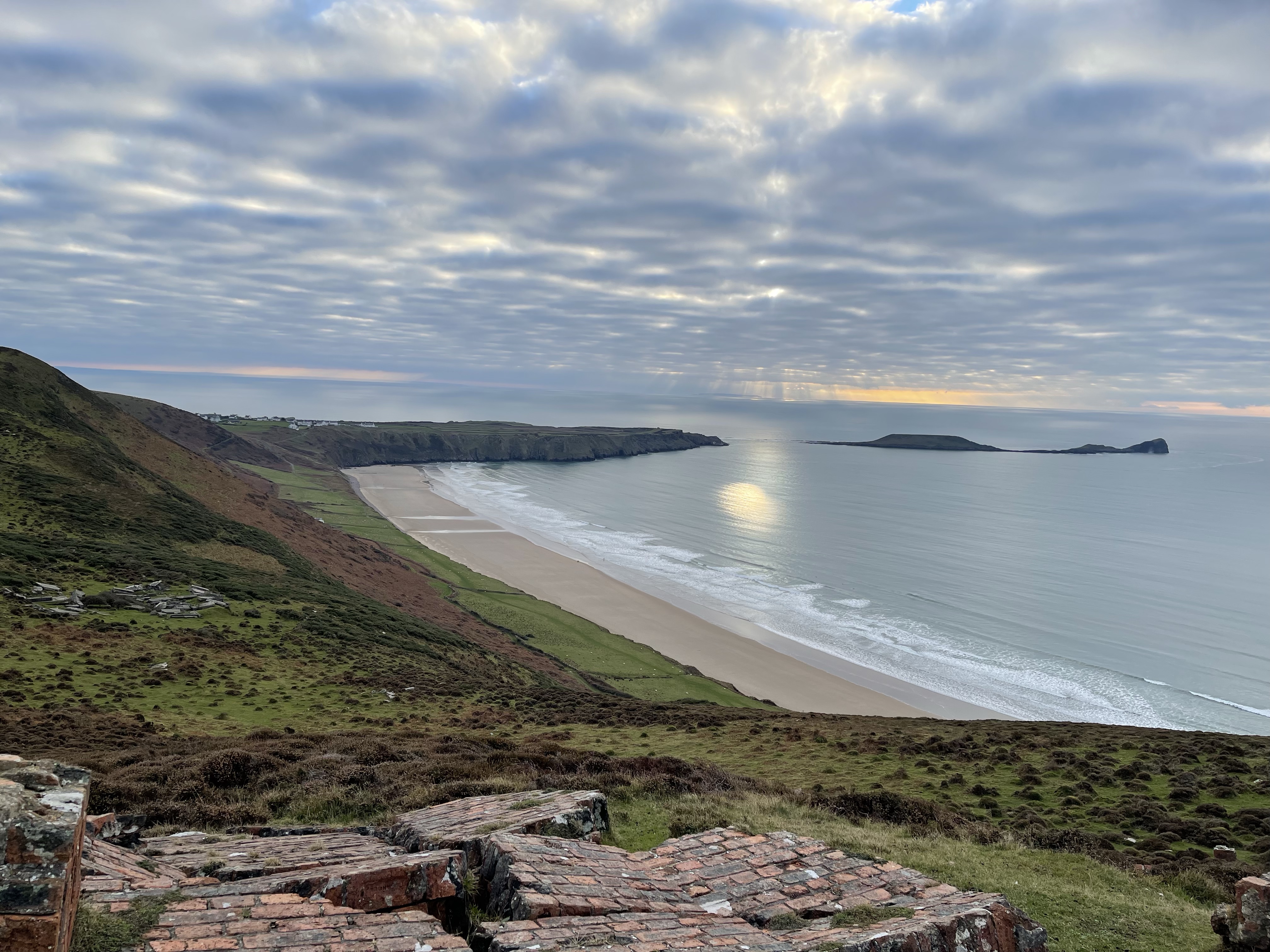
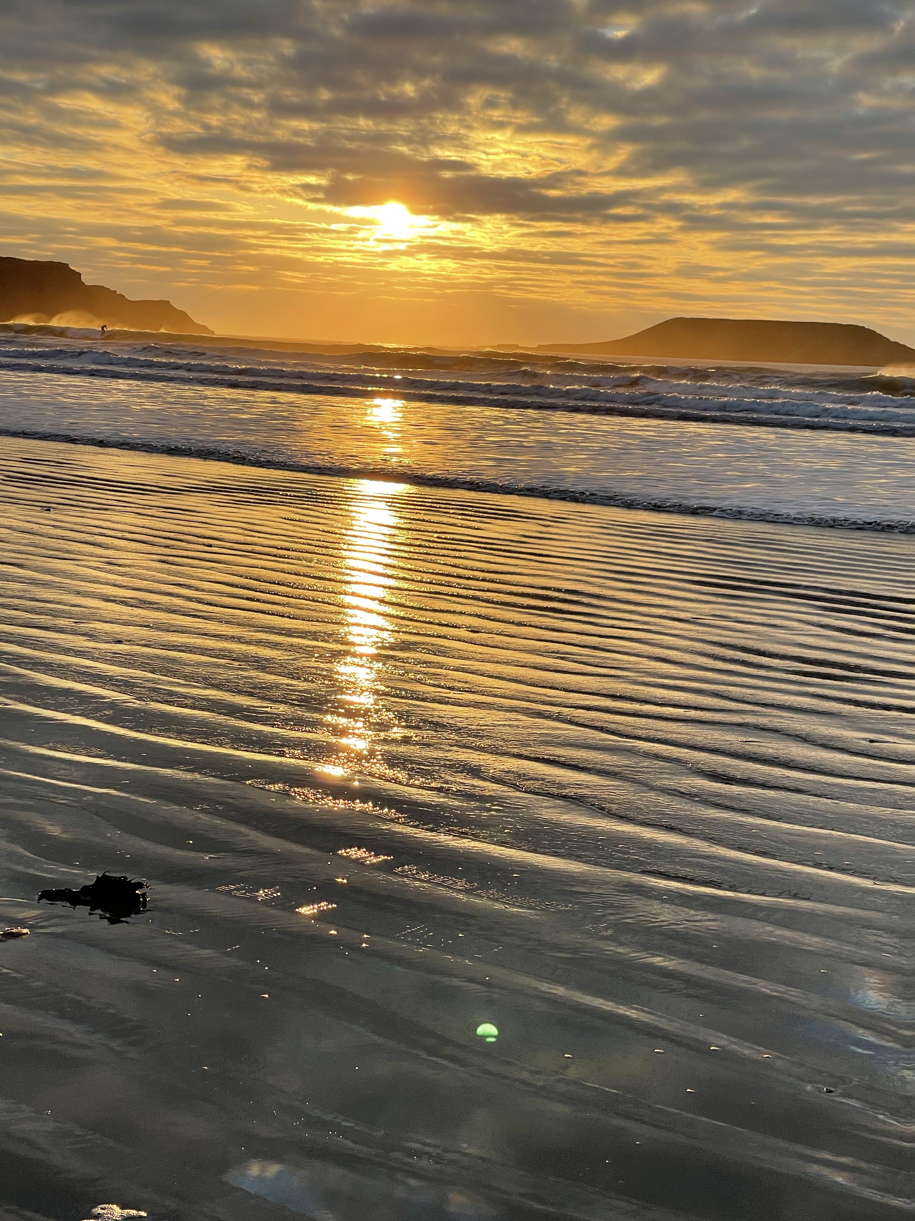
Off to. Rhossili in South Wales today, setting off in the dark. Annie has brought her husband along and there are two new faces for our group today. Bit of a doze on the way and we are ready to set off quite early. Timing is imperative for this walk as there is only a window of about two hours either side of low tide to be able to walk out onto Worm’s head.
This is to be part one of the walk today for Steve and myself – Jane our driver and the other four are going for lunch – really didn’t see the point in getting up that early for half a day’s walking and the offer was there to do the Rhossili Hills as well !
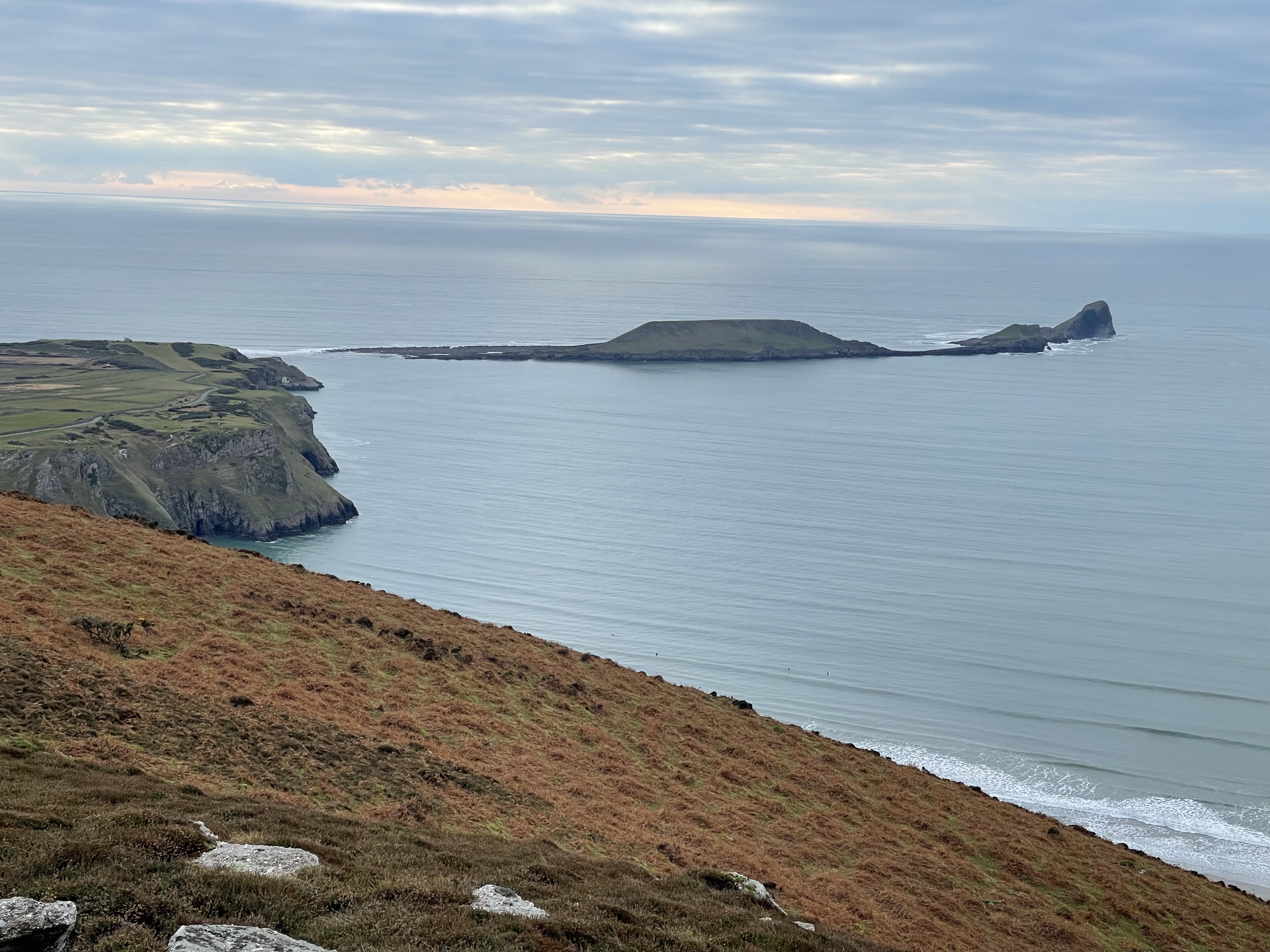
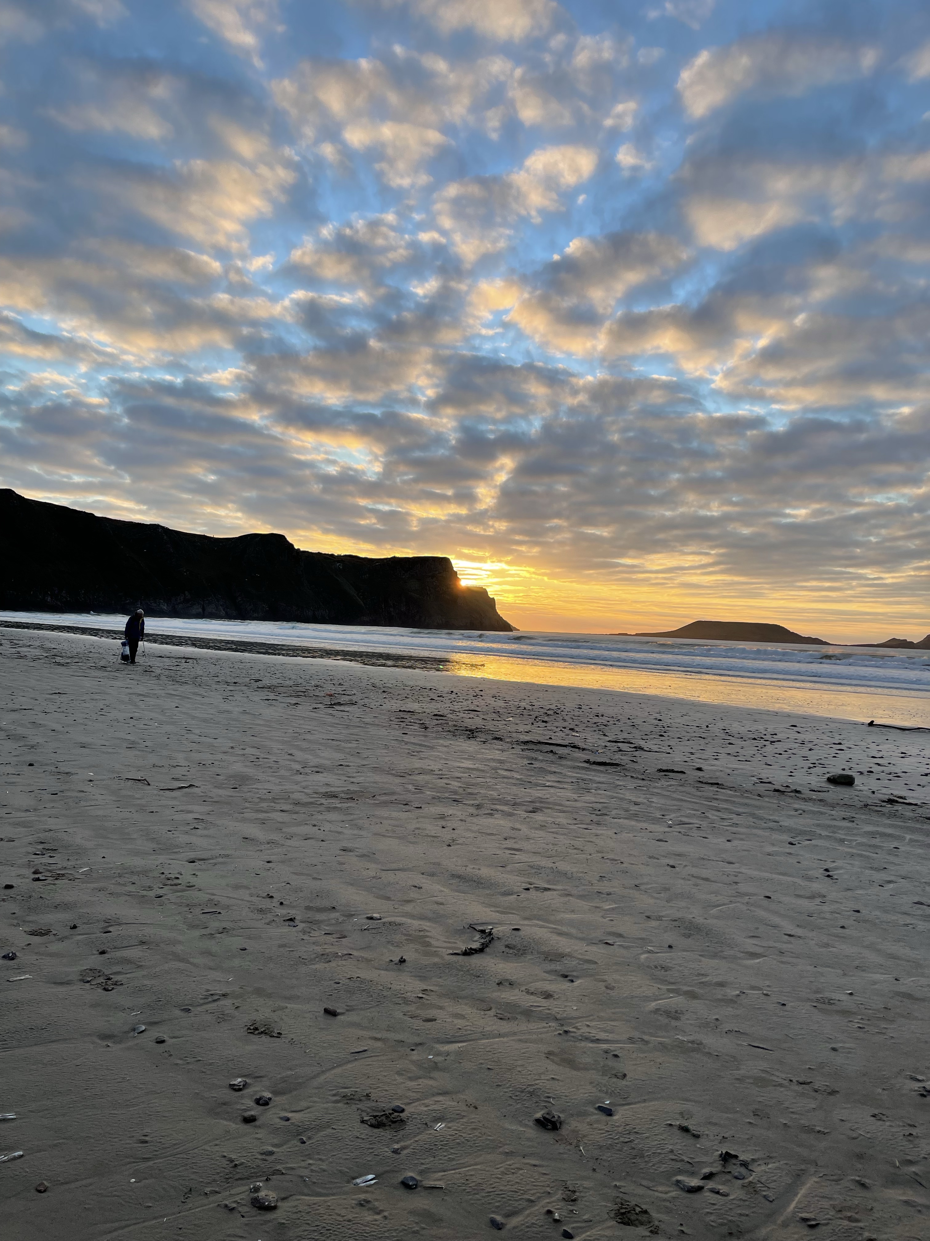
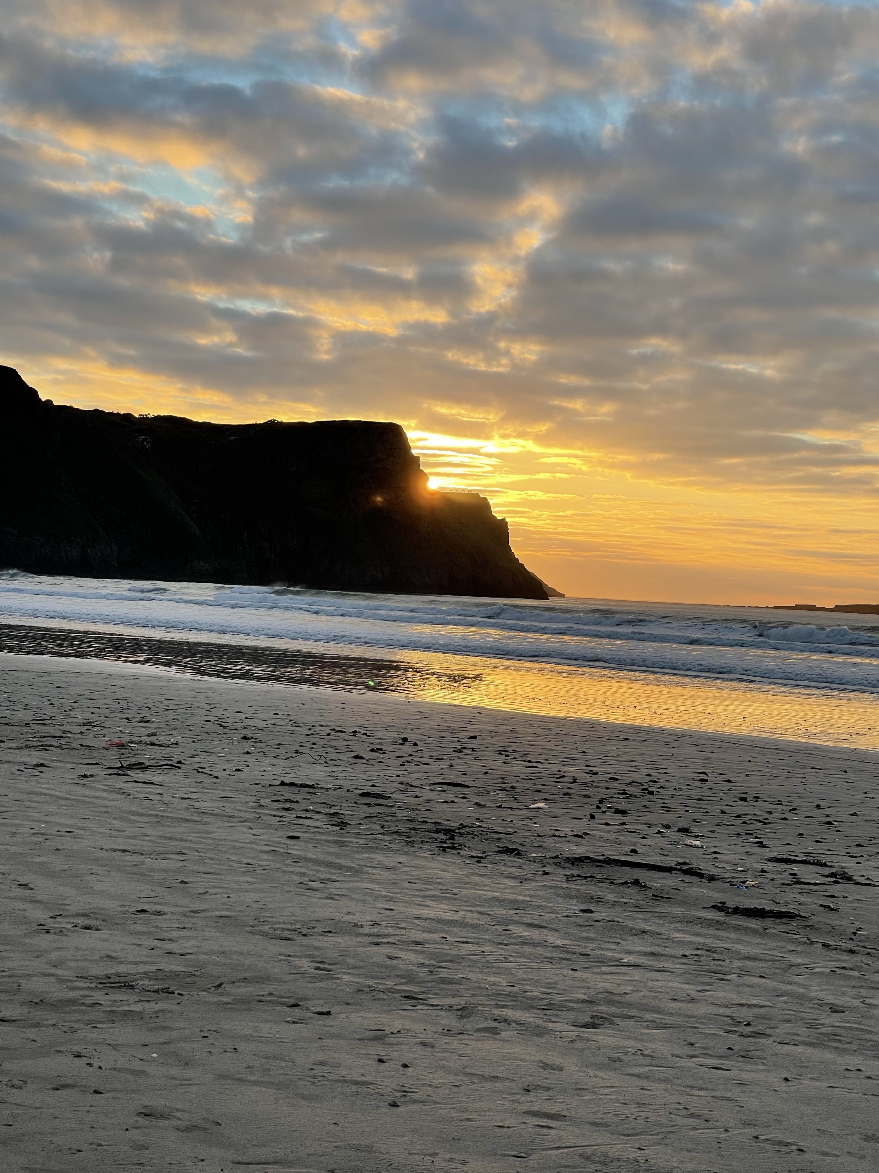
We are setting off at about 9.45 and the end of Worm’s head can just be seen jutting out into the sea.
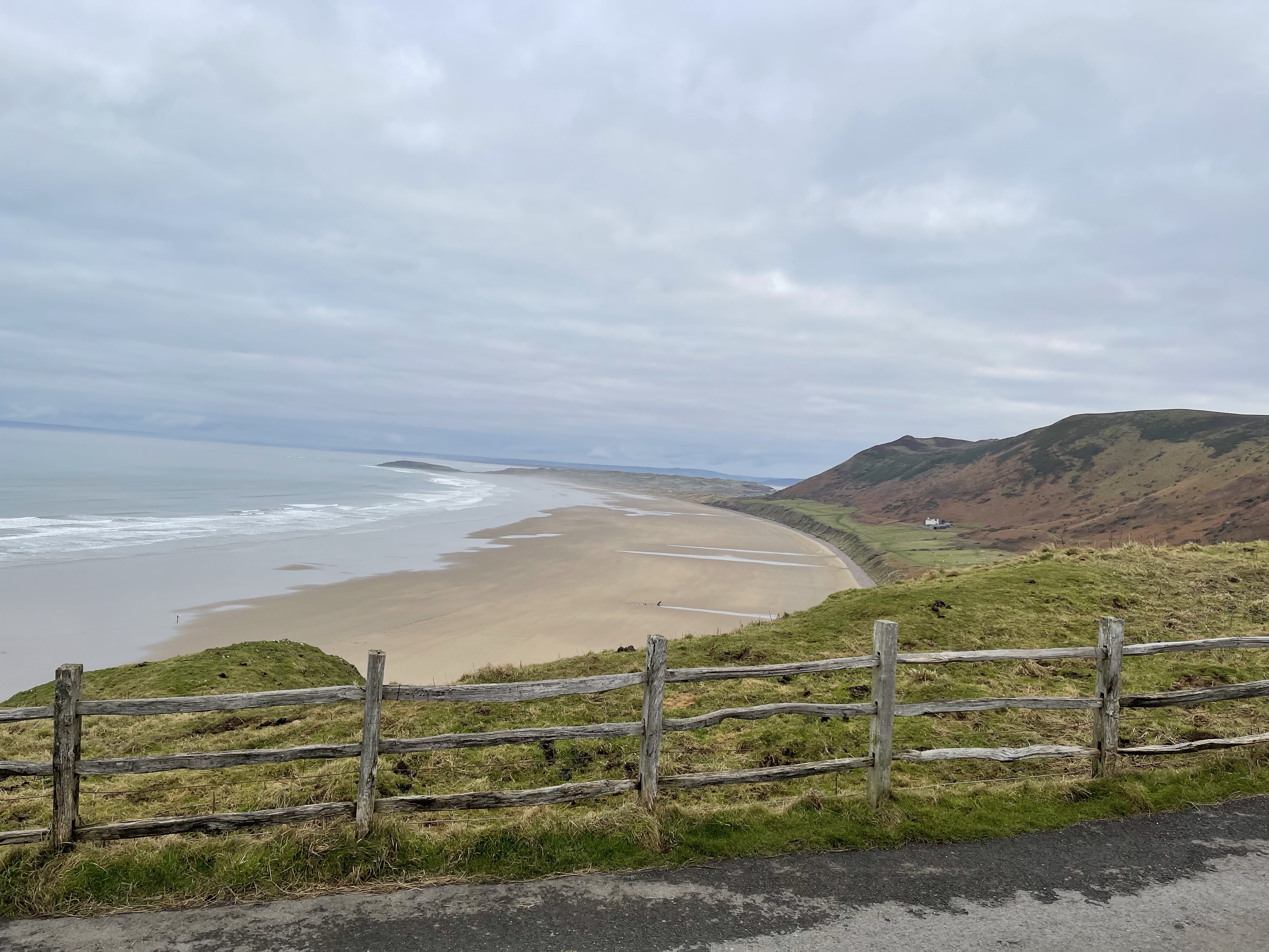
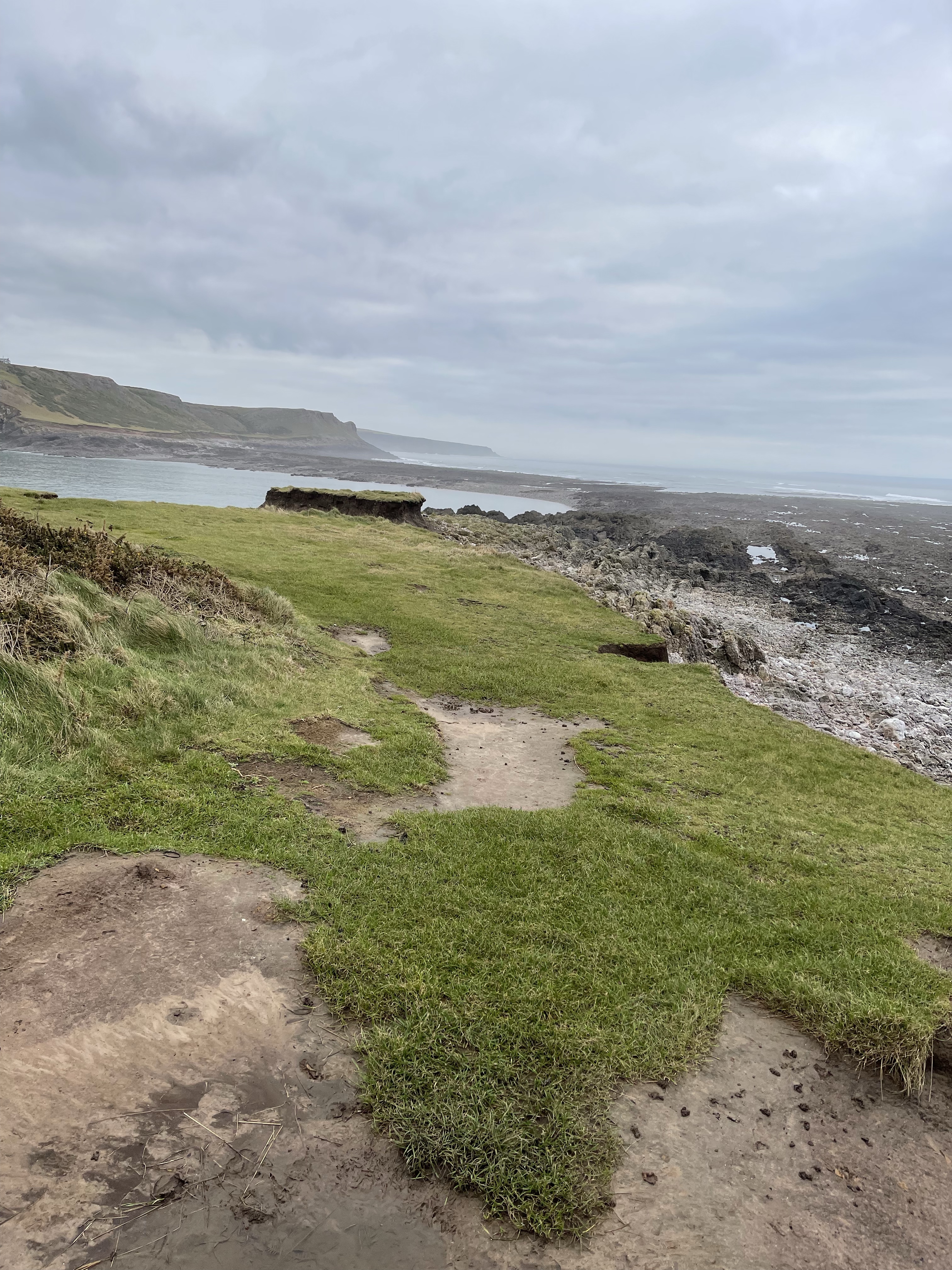
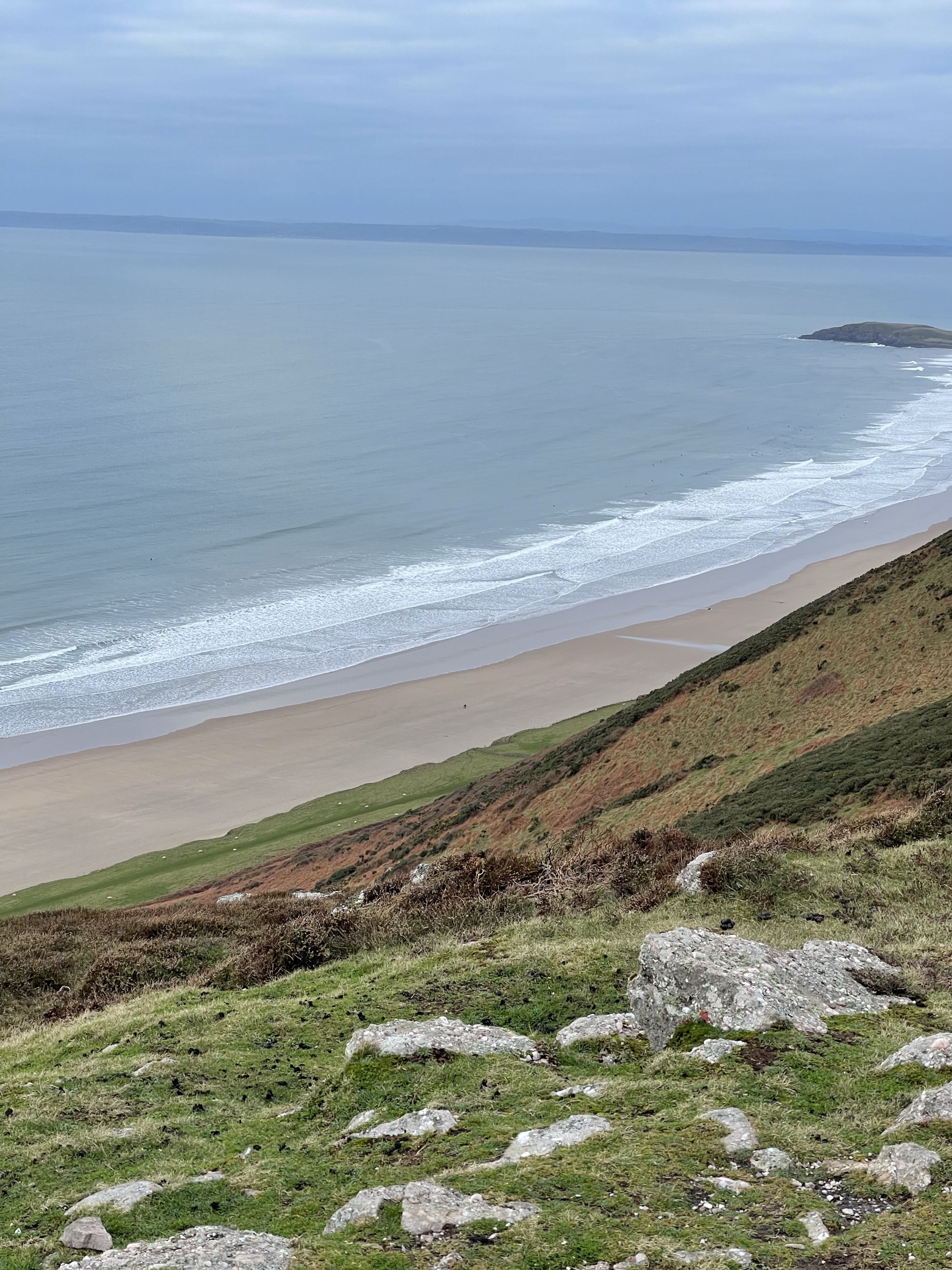
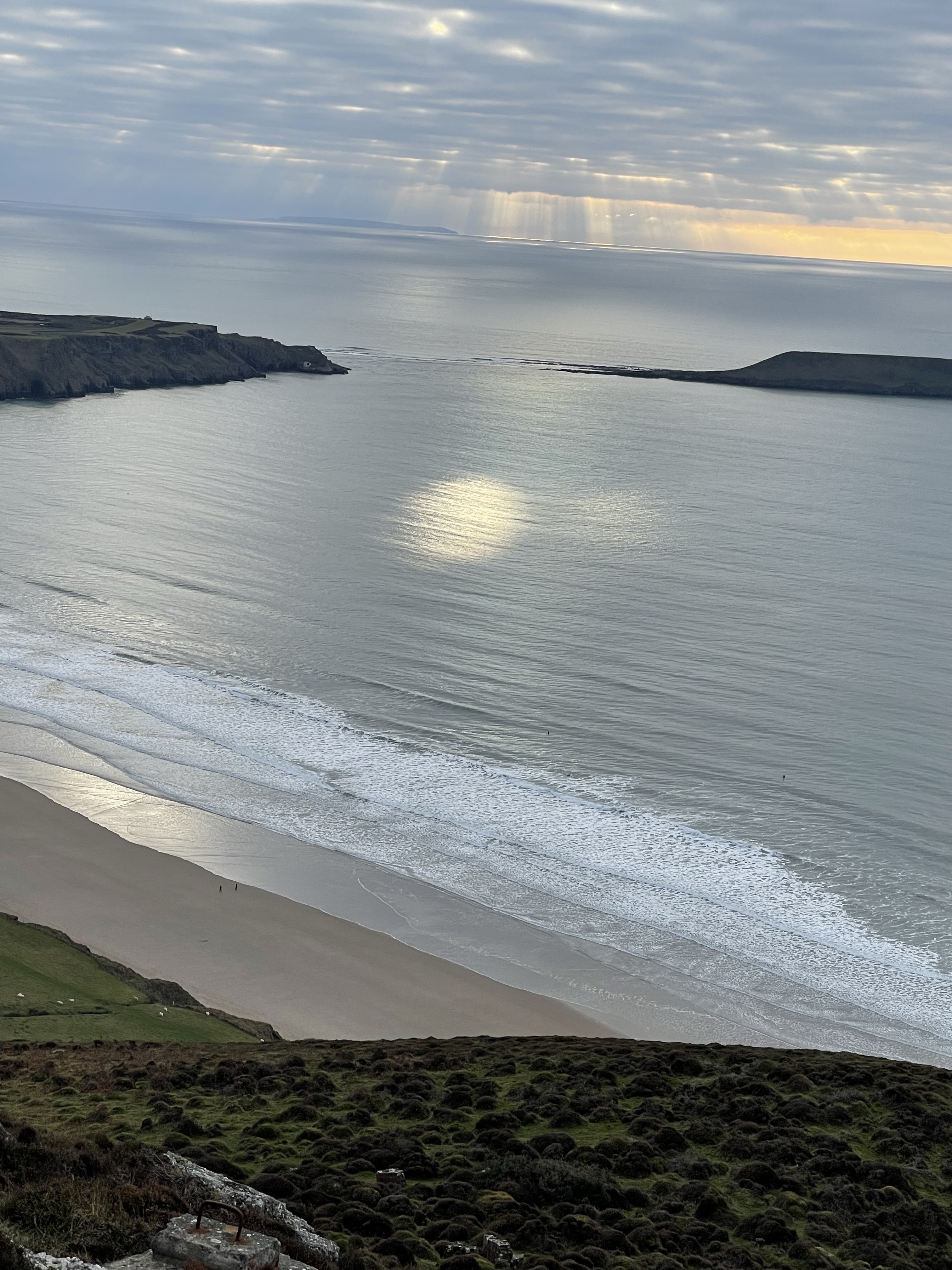
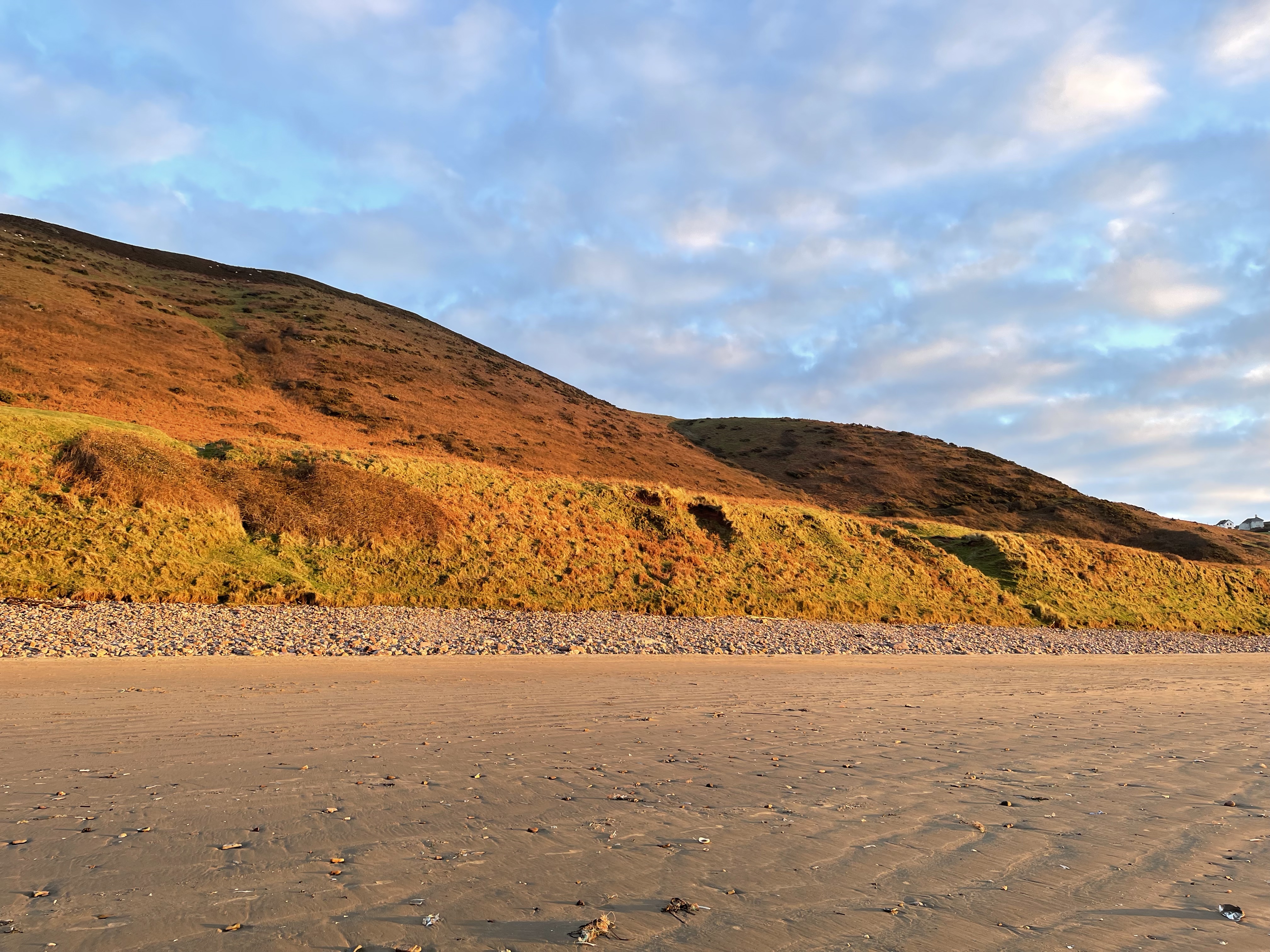
In contrast to the previous walk I’m already feeling much more excited about the venue and the day ahead. Looking back a wonderful beach can be seen and the hills I will walk on later. Animals perch wherever and usually don’t fall off. The sea seems quite calm and the tide is still going out.
A warning sign tells us about the restricted crossing times for the day and as we descend I decide one of my walking poles could be quite useful going across the damp rocks and exposed shoreline.
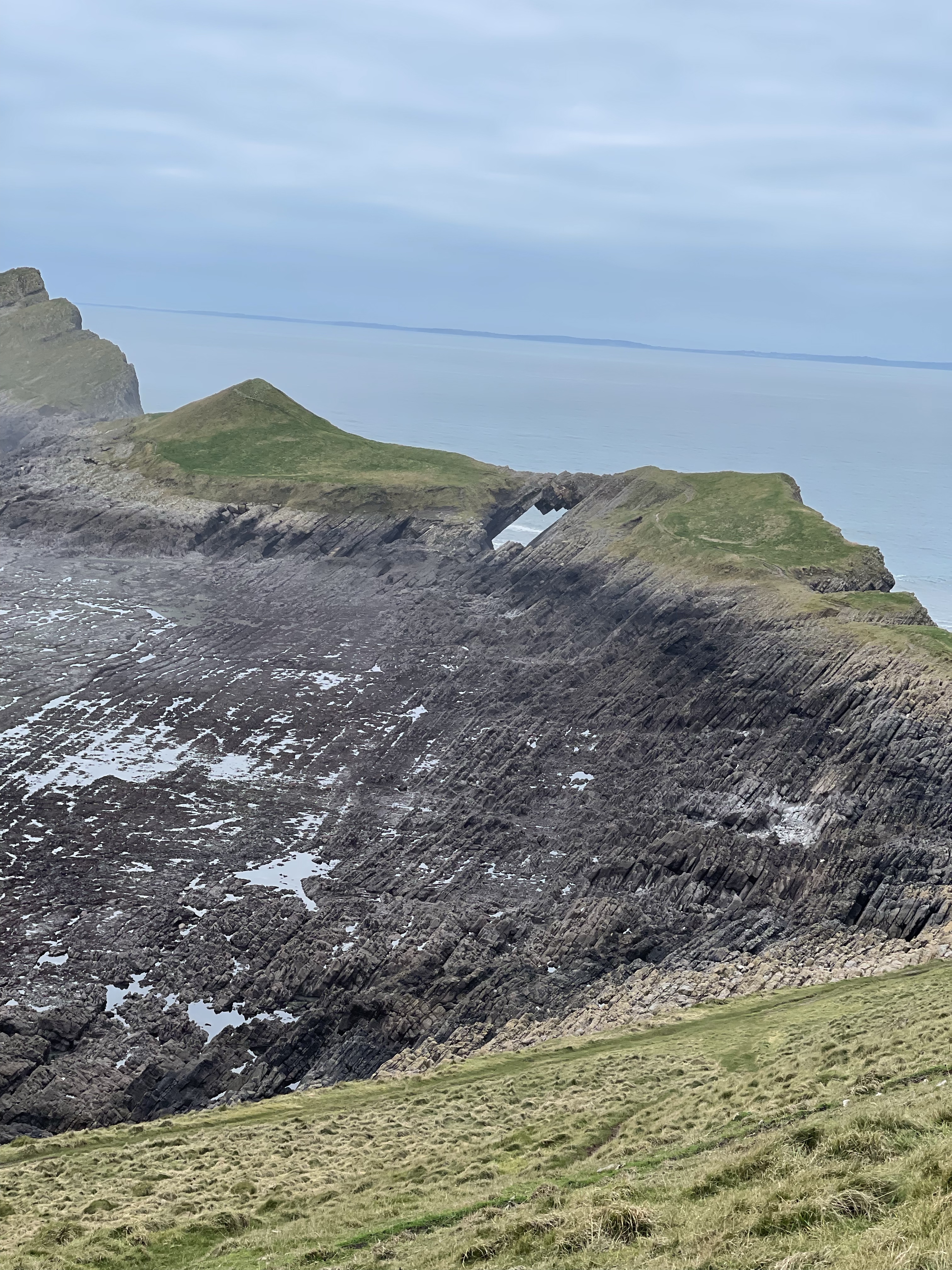
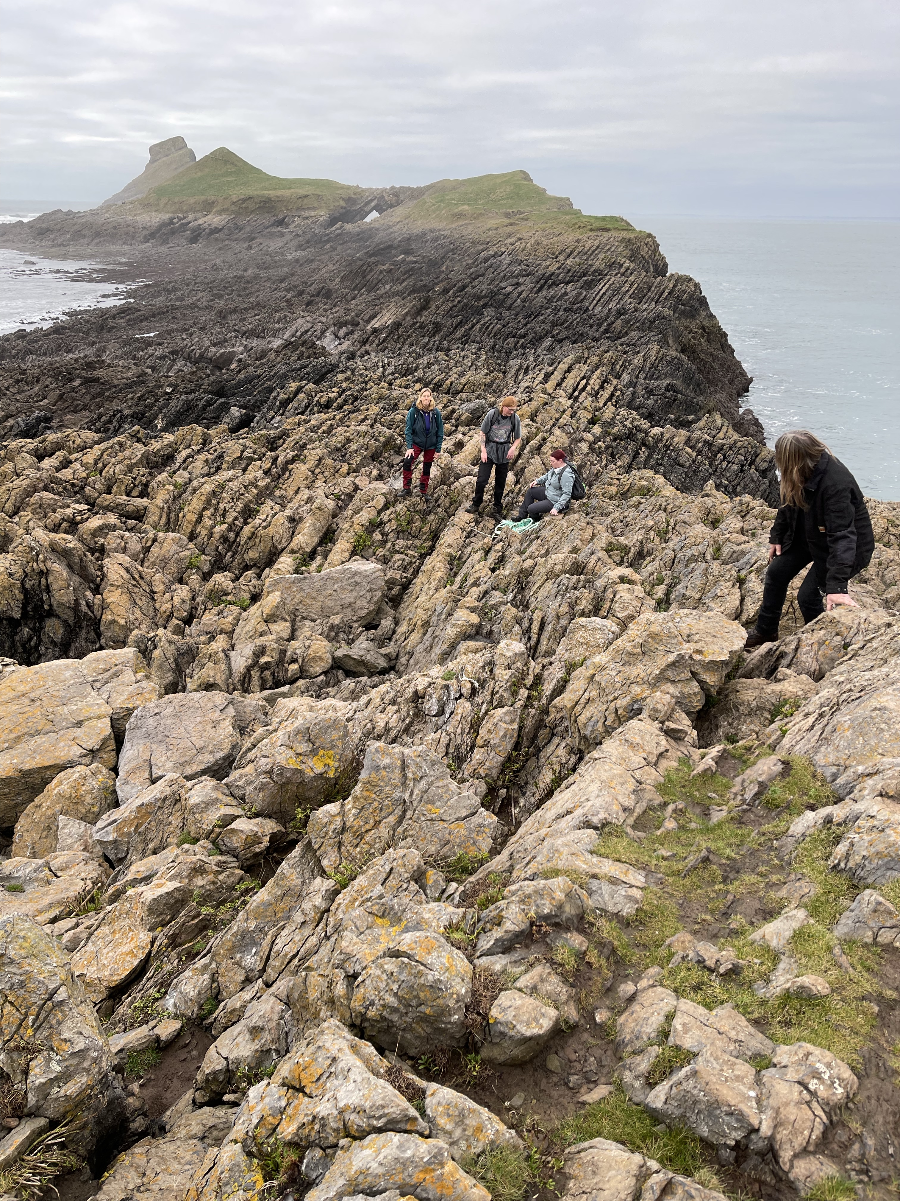
After crossing some areas of rock we were for a short while back on a grassy area. The arch would need to be crossed and was not very wide – best not thought about!
Some tricky footwork and traversing of rocks which were multilayered and on their sides. Concentration was to the fore and very careful foot placement – very easy to get your foot stuck in this type of terrain but none the less exhilarating, walking poles are no help at all at this point but hands are very useful !
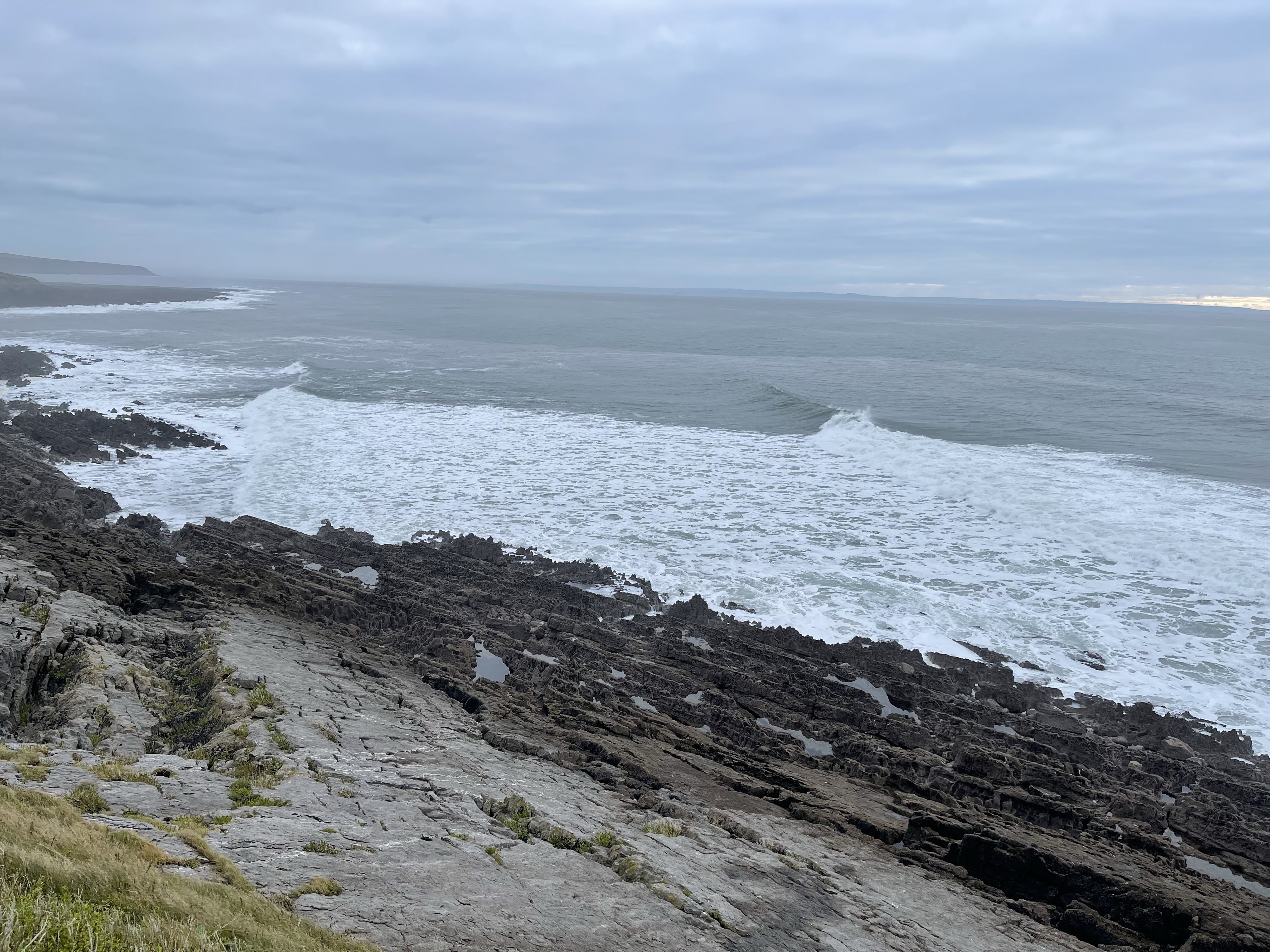
We do get almost to the end and Tom who is younger by far than the rest of us does climb up the stack at the end. We wait for his return and set off back without quite reaching the end as the tide seems to be coming in quite ferociously and a little quicker than expected. We really didn’t wish to be cut off. Small matter of the ragged rocks again – slightly easier this time – perhaps it’s knowing what to expect. Finding I can bend and flex into more situations just can’t quite manoeuvre if I bend my left leg too far underneath myself – it will come I’m sure. This time last year I was on crutches and had only had the first hip replaced.
There is a slight sense of urgency coming from Steve as we complete this difficult section but still have the flatter area to cross with the sea noticeably encroaching from both directions.
Back up to safety just under the coastguard look out room and it is 12.47 and as we look back we can see that the sea has almost covered where we had been not that long before. All adds to the excitement, that and a sea breeze what more could you want?
After a quick lunch break we set off for part two which was to be about another 7.5 kilometres – managed to fail in recording this on either device but the route can more or less be discerned from the map at the beginning of this blog.
A steep climb up through the village, looking down on a very small but solid little church and out to sea. We are climbing up to reach the ridge and a trig point. A well marked path makes this quite an easy climb but not ideal straight after lunch! We are able to see our morning’s destination from this view point.
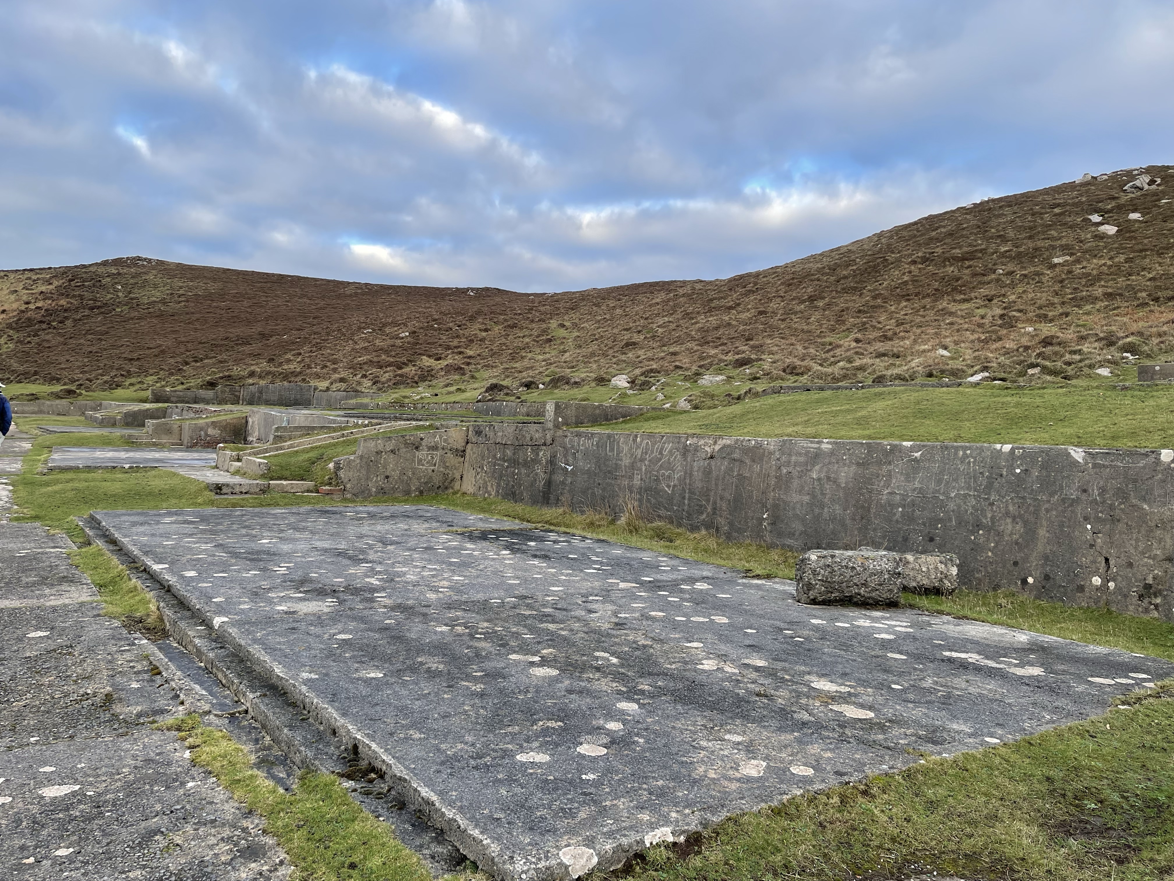
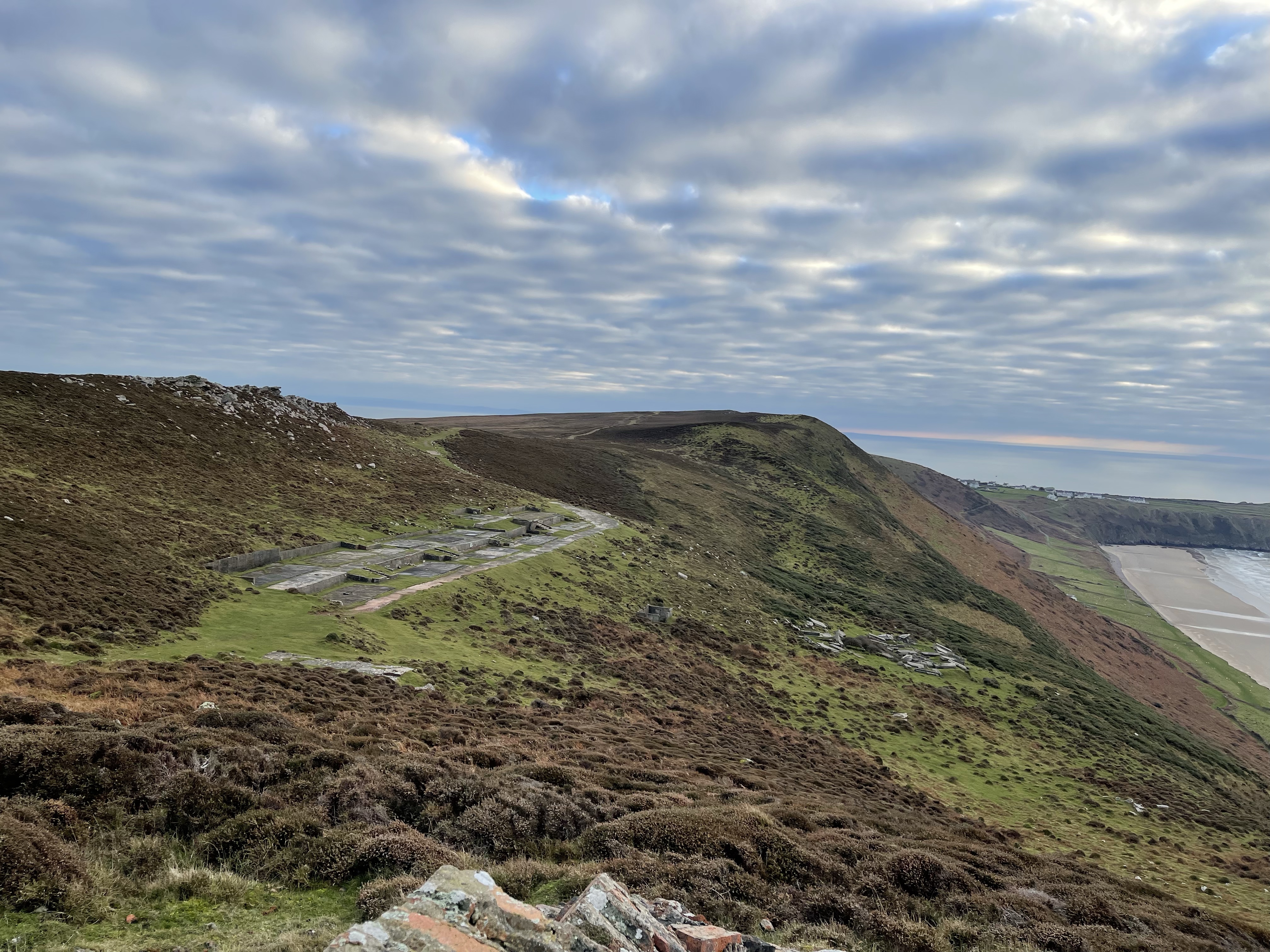
Great views down to the right and over towards Oxwich bay – this is the Gower peninsular and there are probably many good walks to be had. Not as spectacular as to our left though. We can see clearly over to Worm’s Head and down to the beach way below. Today we are walking along the ridge and before too long come to some strange concrete slabs – a little out of character. A plaque explains that this was a World War 2 radar post – quite a lonely but beautiful place to be stationed.
After climbing up a bit further we start a descent down towards a caravan site but decide not to go through it and down through sand dunes to the beach. Our path will take us along the foothills of where we have just walked and then hopefully down to the beach. I should have known there would be scrambling down a steep grassy slope at some point!
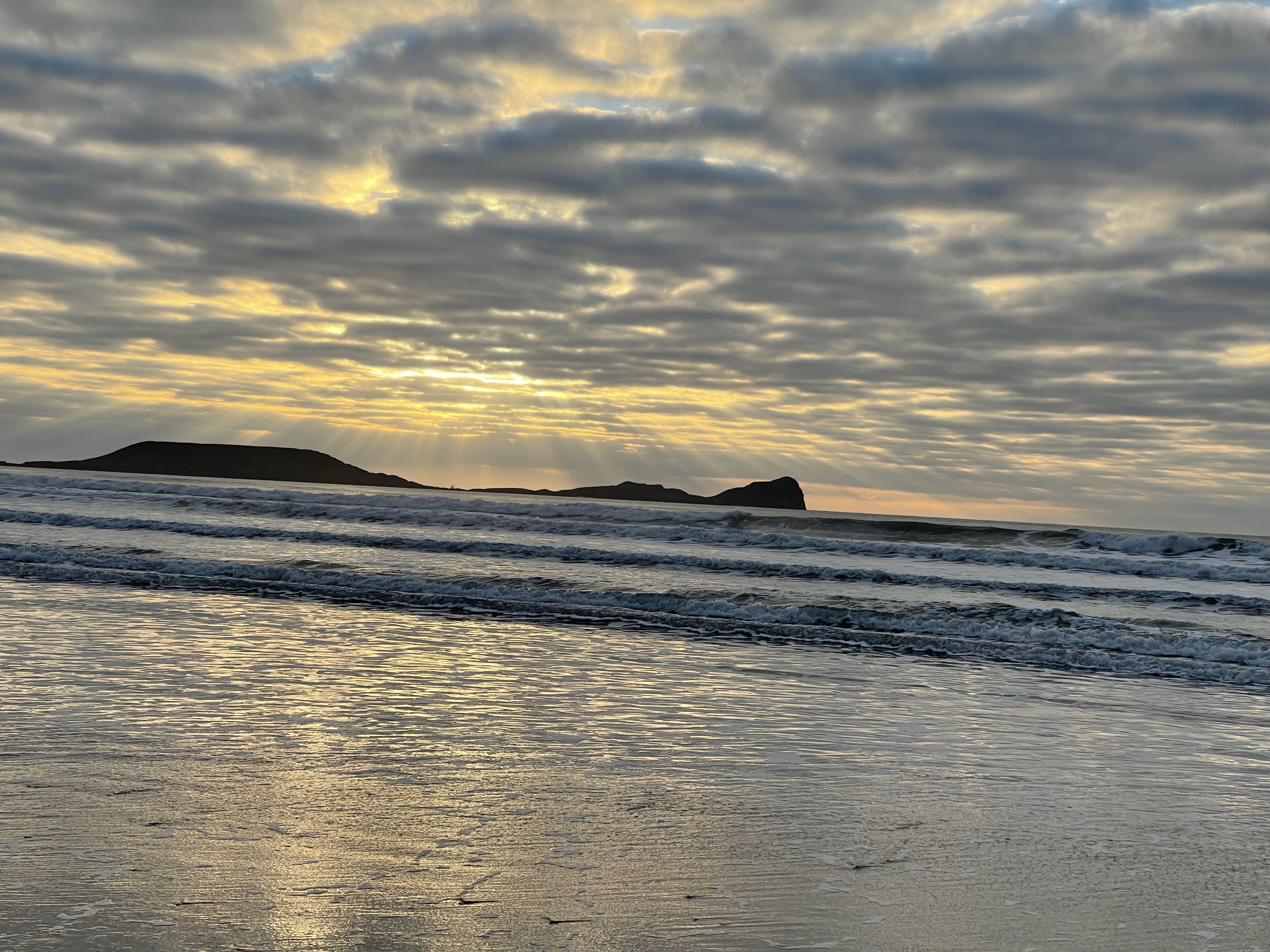
The sky is giving signs of a great sunset and it was easy to take many photos once down on the beach and just soak in the splendour.
The only downside of being on the beach was that the village and car park were back up a hill. Oh well worth it for the views.
So glad I resisted a pub lunch and made the most of being driven to such an exciting and beautiful place.
Something completely different today and started at Millets Farm at 07.00, ready, well almost for the drive down to Weymouth and our walk on Portland Bill. Steve is leading today and Annie and myself are joined by two other ladies, for Betty it is her first walk with the group.
We park in the visitors centre which is just over Ferry Bridge and onto the peninsular. Portland is only joined to the mainland because of Chesil Beach. We walk along this narrow stretch towards the main piece of land and we can see out into Portland Harbour. We divert off of the road and through the Marina and National Sailing Academy boatyard. The Olympic symbols stand out clearly and a rather unusual multi-storey boat park!
We emerge by Portland Castle and climb up to blocks of flats built for the Olympic Games and now let out. An ever changing view!
The path continues steeply up until we reach Fortuneswell and the site of the prison. To our right we can look out and see a series of railway tunnels where the line transporting quarried stone would once have been very busy. The prison is a castle like structure with a moat and is a rather oppressive structure.
We continue on a path southward and we can climb a steep bank to look over into a quarry area. Portland stone was used to build many important buildings in London including the Palace of Westminster and parts of St Paul’s Cathedral.
We continue following the South West Coast Path towards the Young Offenders establishment. Many of the buildings all around are rather austere and grey. There are some strange chimney like structures dotted around – really not sure what these are!
Our route takes us slightly inland and we get muddled up in a new housing estate with several false exits. We eventually find our way out using logic rather than remembered paths that are no longer there! We come out onto the main road in an area called Church Ope. A significant museum is sited here – founded by Marie Stopes ( of birth control fame) it houses many geological exhibits – no time to visit today. There are a couple of trees on this street decorated with Christmas lights and baubles.
A much needed lunch break was taken at some picnic tables made of stone at the edge of an old Quarry area re designated as a car park. After this break our route was closer to the coast and became a little more interesting. However there are still signs from the quarrying and the interaction with prisoners and semi- industrial equipment. This area of coast has caves and possibly docking bays for the transport of stone and the use of lime kilns.
As we approach Portland Bill and the lighthouse there are numerous wooden huts- bigger than conventional beach huts and not in rows. Apparently in the summer these are fully used with people staying overnight.
It’s two in the afternoon and we have a long way to go! We traverse quickly across a grassy slope north of the lighthouse and walk quickly towards the ‘Lookout Station’. There is a clear path along the top of the cliffs at this point. Again past some very grey industrial style buildings. The path continues for a while and we ignore a sign which says path closed – landslide- felt a bit apprehensive.
Obviously we couldn’t get through so it was a scramble up a steep bank, along a bit and then down another steep bank before returning to the original path! Hadn’t quite expected scrambling on steep grassy slopes!
The path takes us on to West Cliff and we are on the edge of Chiswell town and the path leads down very steeply, winding down with sharp bends. We can now walk along the edge of the start of Chesil Beach – partly up on a breakwater and partly on the pebbles.
It is now gone four pm and it is getting very dull. No amazing sunset though! Up on to the path next to the main road and quite busy traffic.
The group has split a bit and I find myself in the unusual position of being at the front. Steve suggest I keep walking back to the car park – this is quite a drag – about 2.5 kilometres alongside the road.
It’s great to be somewhere completely different but sadly I can’t say that I was as enchanted by this particular area as I should perhaps have been. Perhaps in the summer sunshine it would have proved more exciting – oh well, no rain today.
Just over 22 kilometers covered and a new area. Quite glad I wasn’t driving home! 
So more of us today, the core three plus Jennie who had now recovered from Wednesday. Richard who was hoping that it would be shorter than Monday’s walk and Phil, a part time vicar and geography teacher.
A slightly later start as our driver had an appointment first thing and back to the end of the farm track. Pyrton proved to be a small but pretty village and we soon met the main road between Watlington and Chinor. A glimpse of Shirburn Castle was afforded to us on our left.
We set off on a well defined track which is slowly at first, and then more steadily climbing upwards, we are heading for the Chiltern Hills and we know that our route today will be more undulating and feature beech woods. Over to our left we can see Pyrton Hill. I remember taking guides up there from the camp and completing various activities.
We soon come out at Christmas Common on to the road near a junction and have to concentrate to find the next part of our route. A little confusion as the path marked on the maps doesn’t appear to be there – never helpful in wooded areas! Luckily the group at the front spot a way mark and an alternative seems to lead us to the apex of a triangle where we have walked two sides instead of the one we had hoped! We continue through a long stretch of wood. There are however very good waymarkings on trees.
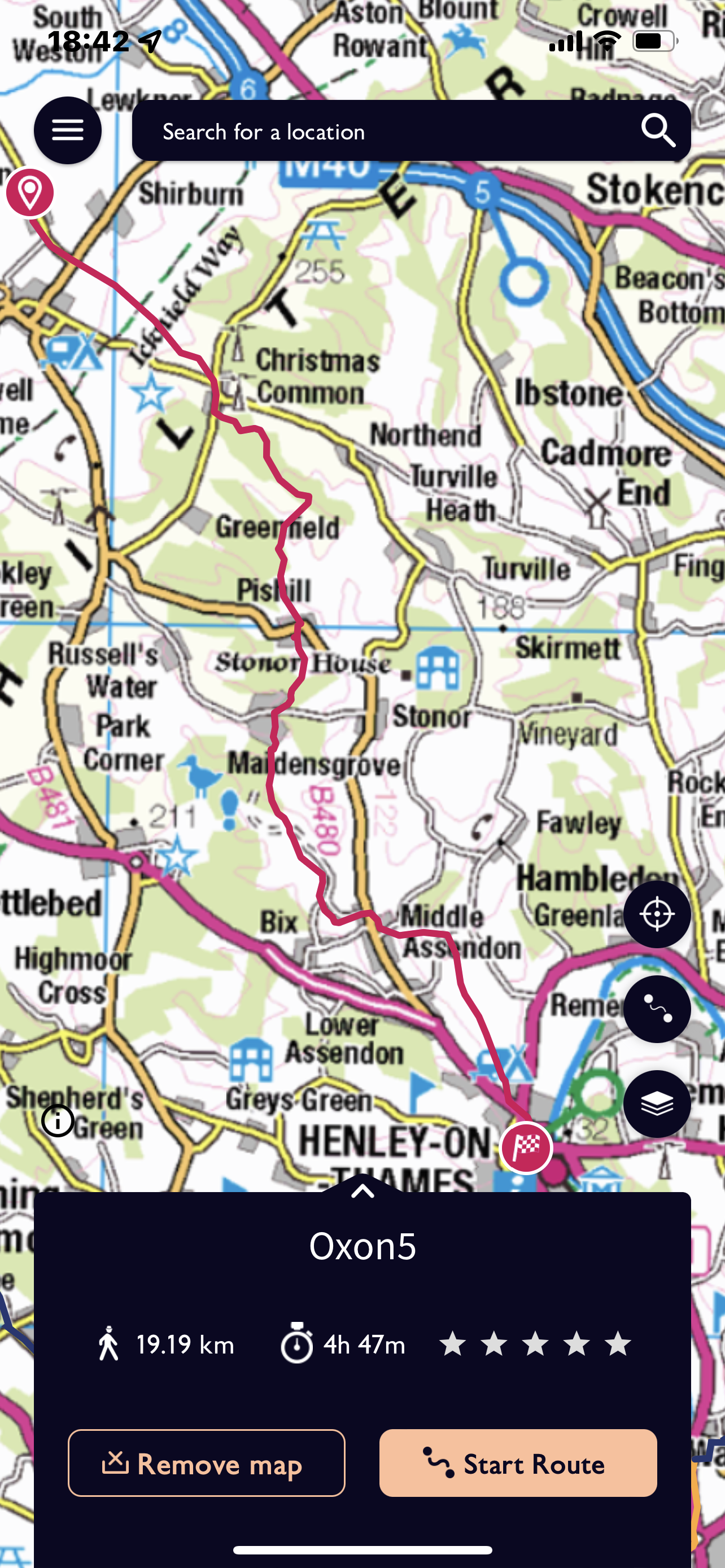
Having been heading south east for quite a while we change to south west for a short distance where the Oxfordshire way and the Chiltern Way are one. There are many small villages and farms at the edge of this escarpment and also many tracks marked as named lanes. Our track splits from the other long distance path and we swing south south east both through woods and along the ridge of a spur until we meet Pishill and use the facility of graveyard benches and pews to rest for our lunch. No coat has been needed so far today which really is quite an achievement for December!
We continue southward and our path just avoids the village of Maidensgrove and is back on the edge of woods again. The Chiltern escarpment can be seen clearly and our path takes us towards Warmscombe Lane However we are heading for Bix Bottom and just before reaching this hamlet we see the ruins of St James’s Church, obviously once of great importance.
A short distance on a very minor road allows us to pick up a bit of speed before reaching Bix Hall Farm and Middle Assendon. It is up hill out from the village and reaching the top of the hill we cross Dobson’s Lane and start our descent down towards Henley. Gradual at first but a steep final section through parkland. The light again fades and we are treated to another wonderful sun set and sky. Four out of five days is pretty good plus no rain at all today!!
The path comes out abruptly onto a footpath at the side of the busy A4130 which comes from Oxford. To be walking next to cars and by shops seems rather alien after five days with very little in the way of urban disruption. However a cup of tea sitting outside a cafe in the main square with Christmas Music playing and the subtle Henley decorations is quite a festive way to celebrate our achievements. A little over 19 kilometres today and a fantastic day’s walking.
Really pleased to know that after a gap of far too many years I can still walk a reasonable distance on five consecutive days. Here’s to the next long distance path – never to late to start !
So back to Menmarsh Guide Post – only the three of us again. We had to start a little later today, but at least the journey to the start of our route was quicker than the nightmare we had had the previous evening getting back around Oxford. By mutual agreement the short section travelled in the van last night, was not walked! However Annie did greet us with the joyous news that it needed to be about 15 miles again today! It was actually just about 1.5 km shorter than the previous day!
A track set off directly from the road junction and there was no rain ! A rather strange feeling.
We have a forested area on our left although we are walking on a track and then through fields or rather one field which circuits around the wood and was probably 1.5 kilometres long. We are heading for Drunkard’s Corner. This is an open access area Brentwood Forest with many distinct paths cross crossing this large area. I’m reminded that on of the Guide Districts was Bernwood
Nothing to distinct about this area, we pass alongside Park House Farm and then drop down to a track which obligingly crosses the M40 over a small bridge. The fact that we have a section on metalled road means that we can keep up a good pace which should help later in the day.
Our first major landmark is Waterperry Garden’ s and farm. Having escaped the dog in the farm yard who really didn’t want to let us through, the farmer apologised and pointed out that there was a farm shop in the barn. We decided to take a look and all bought something from their excellent bakery. We could have deflected into the Gardens and house proper but decided we ought to keep going.
So we continued to Waterstock and over Bow Bridge, this time we were crossing the river Thame which leads down to the Thames. The path skirts the lower part of the village taking in the church before it goes alongside and then through a golf course.
This comes out on to the A418 and after a very short distance along the road crosses fields again and a disused railway before quite a sharp left turn into the very linear village of Tiddington. There is a more wooded area to our right and we cut across to Albury. This is a climb up to a much deserted village but with a church remaining.
The path drops down and up again and there is some feeling of purpose and grandeur about the area. Our path meets with the Thame Valley Way but drops down towards Rycote Park and it’s house. Once a place frequented by royal visitors, Henry VIII, Elizabeth 1 and Charles 1 included. The path takes us next to Rycote Chapel which is apparently of significant interest but unfortunately is locked. It does however have benches and some sunshine so makes for a decorous lunch break!
From here is a pleasant section of woodland walking before crossing the A329 and passing along the edge of the Oxfordshire Golf Club , very decorative lakes can be seen to our left. Having reached the summit of this undulating area we drop down to Tetsworth which as a village is dissected by the A40, in fact half the village is squashed between that and the M40. We are all glad to see that our route across this to the south is via an underpass!
We are crossing more fields but noticeable less wet than at the beginning of the week. We travel south and follow a path with lakes to our left and through a short area of woods. We reach a small road and are able to quicken our pace, still warm and no need for my jacket. Next to Wheatfield, which was our original destination , this is a deserted village with a church still standing and farm buildings around a courtyard which once belonged to a much bigger house.
We are crossing fields again and the light is fading a little but they are well marked and start to follow closely to the field boundaries. We surprise a large deer with a very white rear, identifying itself as a Roe deer; also lots of prints evident at this point. We are heading towards Model Farm.I’ve often seen this signed when I’ve been in the area. This was a farm set up by Lord Macclesfield in the mid 19th century and was reported to be very technologically advanced. This is an area very dear to me having completed two big County Camps at adjacent Shirburn Castle. A slightly crumbling home built in 1377 complete with moat. Lady Macclesfield was a kind and generous natured County President for the guides – very down to earth and practical.
We can see the Chiltern Hills on the horizon as we approach this area and as it gets darker it is possible to see the lights from the cars coming through the Chiltern Cut on the M40.
We are pleased to come out on a track which takes us down to some farm buildings which are positioned at the north end of Pyrton Village. We know that our lift should be somewhere in the village. It’s quite dark by now but several cars coming through the village so we phone to get the vehicle to us rather than walking through the village – we’ll save that for tomorrow. We did get a little rain about half an hour before we stopped, sufficient to put a coat on but almost stopped by the time you’d zipped up!!
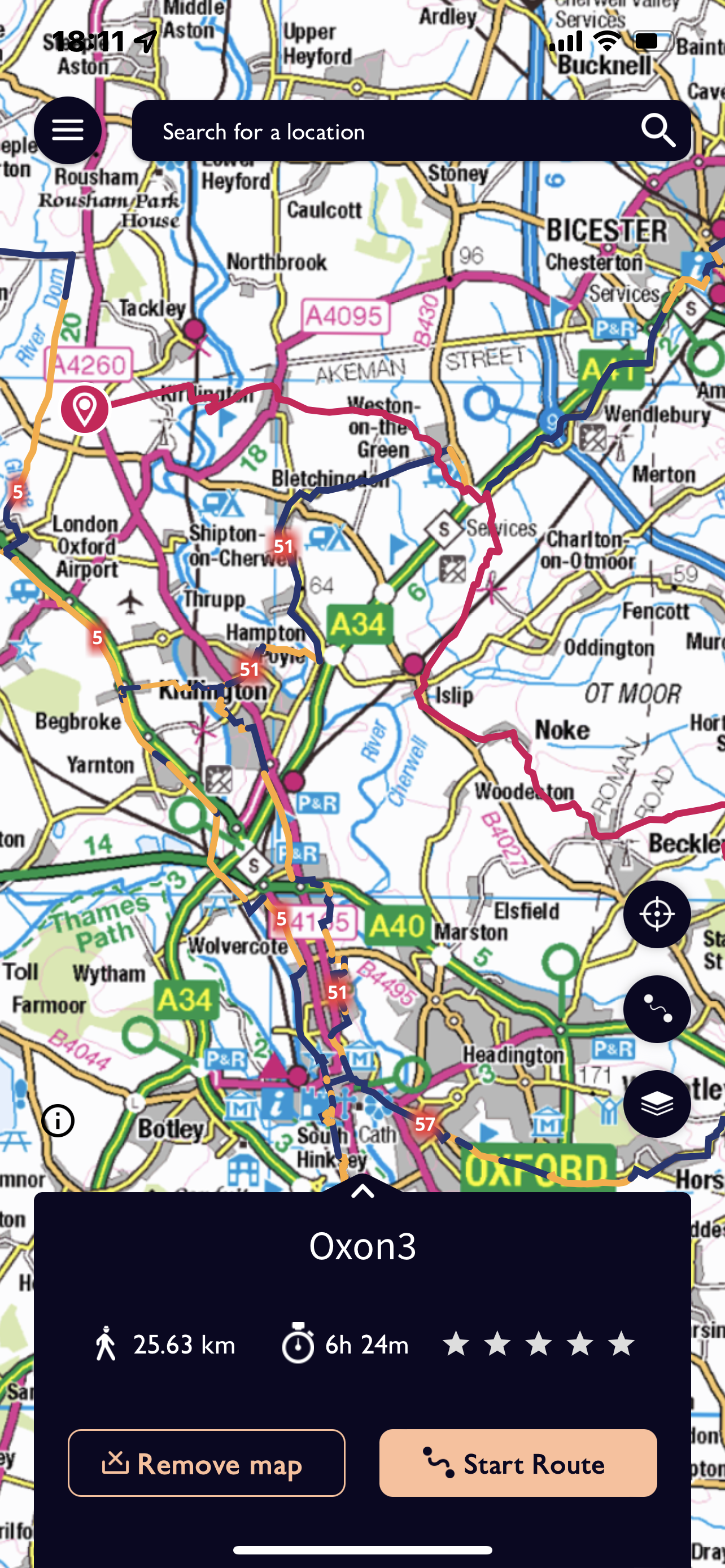
We have Jennie with us again today and I’m not sure she had realised that this was going to be the longest day! It turned out to be 25.63 km and not surprisingly we finished more or less in the dark.
So setting off from Millets at 8.30 we had a more straightforward journey as we didn’t go via Carterton. We started our route at Sturdy’s Castle where we had finished the previous day and were quickly on a track which again followed ‘Akeman Street, the Roman Road. Our path cut across the side of a hill and was not too difficult in the drizzle. An abrupt turn to the right shortly before the railway line, across it over a very high metal bridge and then down towards the Oxford Canal.
The River Cherwell intertwines in places with the man made canal and we cross a series of weirs before reaching Pigeon lock. A rather special place with a complex system for horses and men as they negotiated changes in height of both water and land.
The path almost doubles back on itself alongside the canal and there is evidence of old quarries leading down to the water as well as areas now designated as nature reserves. This is close to the village of Kirtlington, medieval fishponds are marked as is a Park and large house. I’m reminded that this was another site of a large Oxfordshire International Guide Camp where I helped provide various activities.
The richness of the village may be linked with sheep or stone and the closeness of the canal must have been a huge asset. The walk through the parkland is pleasant if not still a little damp and we head for Weston on the Green.
Before reaching the next village we did have a bit of an incident! We approach a field containing three horses – not so bad you might think but they were very frisky! Bucking and galloping and rearing up at each other – just playing really !!
Anna was terrified and I was none too pleased, luckily Annie had come across them before on her trial walk and after a great deal of hesitation and with Jennie and Annie on the outside we walked across as a block and went as fast as we could. With great relief we reached the exit point!
Even though we’ve had a snack stop at Kirtlington we decide to ‘shelter’ under the eaves of a pub at Weston and eat part of our lunch. Several cars arrive in the car park as it approached 12 noon and occupants alight and make a dash for the door as it opens at midday! They were very surprised that we were not joining them! Refreshed we cut round the back of the village and follow the slip road which passes over the A34 just prior to meeting the M40.
Not the most exciting section next, across fields mostly- some of which were rather waterlogged. Annie had suggested we brought bags to put over our boots – except that Jennie hadn’t got the message. Although we had to do a few diversions and some hedge hugging we did manage to cross the area reasonably unscathed and without extra protection!
We left the fields and entered the north east corner of Islip. Now a small village but once boasting 22 inns. It transpires it was on the route between Worcester and London and the River Ray could be crossed at this point. Time to eat the rest of our lunch and we availed ourselves of chairs which were sitting redundantly outside the -up for sale- Swan Inn. And the rain had stopped!!
The path climbed up across fields, not quite as muddy as the previous two days. The path led through a kissing gate into the intriguing village of Noke. This area between Islip and Noke would have been very important during the civil war, with many battles taking place near Oxford.
There is a large Manor house and rectory in the village but quite a small church. It first became a manor after the Battle of Hastings when William designated areas to his various kinsman and important knights. The name means ‘ area of Oak’ and Prattle Wood and Noke Wood still exist.
Noke was also one of the seven villages surrounding Otmoor and was part of the uprising against the 1815 Enclosure Act. We skirt around the southern end of the Moorland which is very wet. The River Ray that we crossed in Islip runs through it and at various times the area has been partially drained.
We continue in round to Beckley, we have seen Beckley mast from a distance but never actually go near it. Looking out over Otmoor we see Buzzards which makes a change from Red Kite! A short stretch in the village before we are back out across fields. A slight hiccup with navigation taking the wrong identical and both quite hidden stiles. Being able to really expand the map on my phone does help in this situation. For the third afternoon in a row we are treated to some exciting skies. The down side of this is that we still have a fair way to go!
We are heading for Menmarsh Guide Post – a cross roads. Having touched on the edge of a wood and across some fields in the fading light our last section is along more of a track towards Danesbrook Farm. We hit a particularly dark stretch and do jump as a figure appears and shouts hello. Steve has got bored waiting and has come to meet us. They’ve parked at the farm and have saved us the last kilometre – nobody complains!