The next 50! Walk 41 – 30/01/2022

Again from home and trying to plan a shorter walk from Wantage but with village interest as well as variety of terrain. I will also need to consider what information to include when offering these walks.

So off down the lane and round through West Lockinge and the stable and around the wall towards the church.However before I get to gated entrance I am cheered to see the familiar site of snowdrops in the area surrounding the church and on the bank by the wall and path that I’m walking on. With a few attempts at lifting the bottom of the fence and holding the camera I was able to capture the joy that these first brave blooms express.

As I continued around the path edged by the perimeter wall of this part of the estate I glimpse a different view of the church and the surroundings.

On passed the church and to the bridge which crosses a Brook which has been artificially enlarged at this point., partly to enable some fishing. It has been recently dredged, probably to prevent the flooding that occurred last winter. The water was really still today giving a great reflection.

I curved round on the road, ignoring the track to Lockinge Stable and took the private road with permitted footpath use which diverts to the left. This rises steeply and very quickly the church down in its secluded spot is out of view. This metalled road soon joins a road which ultimately drops down into Ardington but before too long at a neat corner there is a grassy track leading off. This is the next section of my walk as I go towards Ginge Brook. The sun is shining again!

I like this track, not as high up as the Ridgeway but still an on top of the world feel. A bit of a muddy descent towards the brook and the new cycle track to the Harwell Science Site. Lots of people out today- cyclists, dog walkers and runners.

In the interest of variety I decide to take the well worn path next to the brook. This section is great and goes next to meanders and ox bows – a mini geography lesson. I can remember a step bank when I went this way before – managed to scramble round the first obstacle but then the sharp decline was just a little too much- I had to remember two things. Firstly I was by myself and it wouldn’t be helpful or convenient if I slipped and hurt myself and secondly I was planning this as a potential group walk so I had to be relatively sensible. So a steep scramble up the bank to the edge of the field, where many had walked before and along. Near the end of this section I could drop down into the wood again – I now have a date to potentially lead this walk in April so note to self to explore this section again.

My woodland trail met the path over the little bridge and along to West Hendred Church, several more walkers in this area. Today I was going straight across the road to a path to East Hendred. Before I had taken a left turn as I met the village and walked passed the school. Today I wanted to continue straight on until I came to the main road in the village.

For some reason I forgot to take photos even though there is some great architecture! I didn’t realise that a metalled hut had been changed into ‘The hive’ – somewhere that sells sustainable products and where bottles can be refilled etc. Next the church, the shop, the pub, the chapel and some splendid barns. Plenty to see as I go round Chapel Lane and on passed the now abandoned Plough Inn. What a pity, a characterful building and once quite thriving

Now down Mill Lane and passed the sports club and football fields. A familiar sound of Sunday morning boy’s football. It brings back memories of a few years spent visiting various places on Sunday mornings!

The path now goes along parallel to the Mill and across fields before coming out into West Hendred – not the most exciting part of the village. Then it’s off across several fields towards Ardington. Not sure what the crop is – cabbage, rape – I’m sure it will become apparent later in the season. At the edge of one field I stop to eat some lunch and I’m entertained by one, then two then four buzzards playing on the air currents. There is quite often a buzzard sitting in the field next to the main road in this area.

Then the familiar cry and a red kite comes into view- the fun stopped and the later was definitely trying to dominate.

A message to say my logs would be delivered in about 30 minutes and I’m quite a way from home! So a rather fast pace back through the village and the normal track to home. Just time to stop and appreciate this other sign of spring.

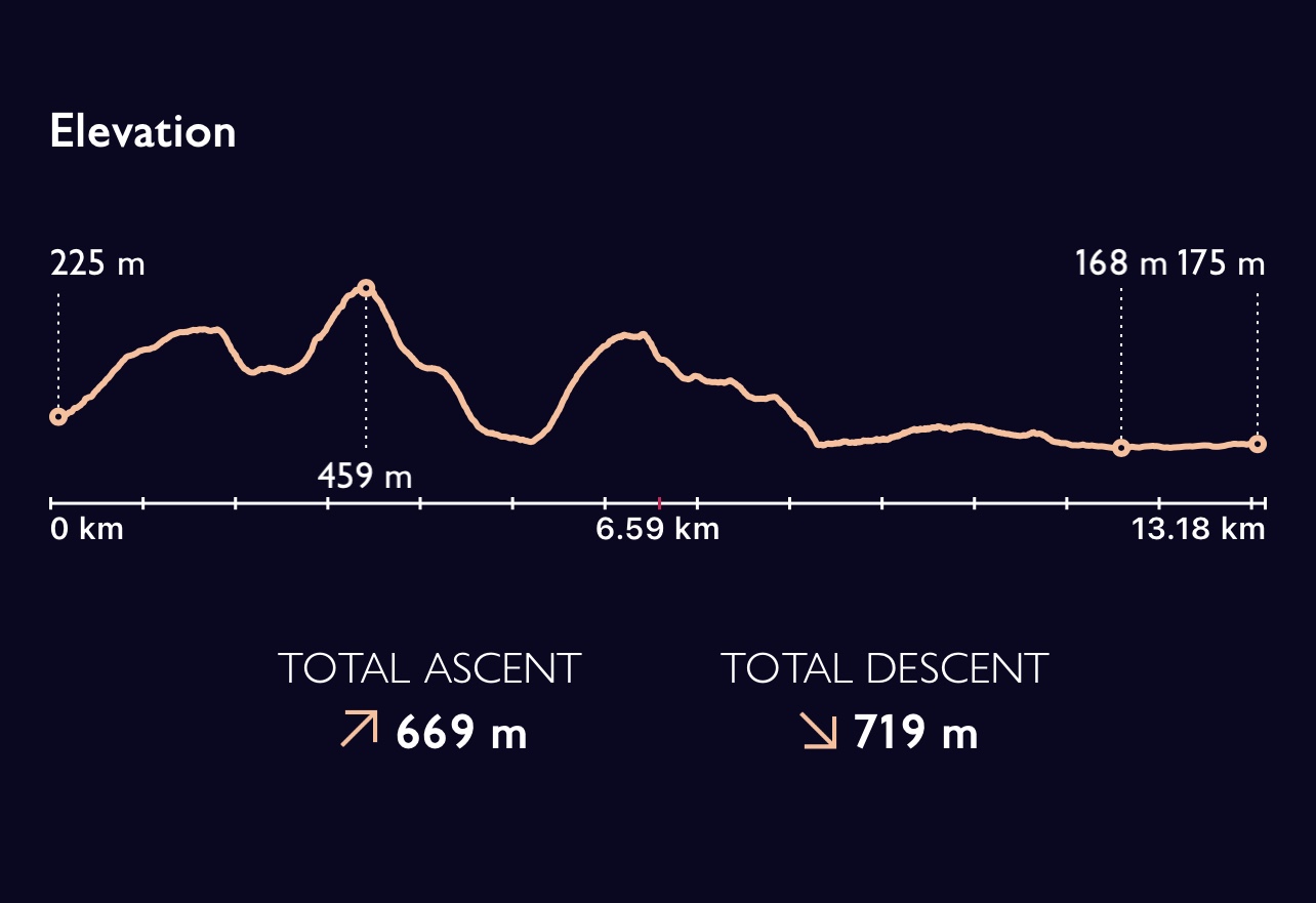
About 13 kilometres/ 8 miles which is hopefully a good option for those wanting a shorter walk.

The next 50! Walk 40 – 28/01/2022

Starting from home again today and with a slightly different purpose. Currently SPR don’t have any walks based in or around Wantage, I’ve been encouraged to present some that can be offered out to members and that I can lead. Decided to go on the theme of Wantage, spring line villages and the Ridgeway. So off I set! First of all we mustn’t forget King Alfred who was born in Wantage in 848/49. He became king of the West Saxons when he was in his early 20’s and then went on to be King of Anglo Saxon England when he was in his late 30’s until he died at the age of about 50. A well respected King who valued education – how fitting that he had a school named after him!

The route goes past the church and down Church Street that used to be called Back Street and was the home to many ‘tanners’. Over the road and down the enclosed pathway to Letcombe Regis, the first of the villages. There has been some clearing along here and the new growth in an around this pool, quite possibly a spring, looks very fresh.

This path goes on and finishes as the edge of the village is approached. Many old cottages to see, a good pub and a raised causeway path. The path soon diverts across fields as it makes its gradual approach to the Ridgeway.

Looking over, the wooded area of the youth hostel, used so often , can be seen on the horizon.

After going on a more or less level path the ‘big stile’ and the start of undulating fields and the serious climb up to the ridgeway are about to start. I hesitate to read a notice I hadn’t seen before which shows a permissive path across a previously unattainable field. This links in with circumnavigating Segsbury Camp, an Iron Age Hill fort. Not today but I’m keen to try this as an alternative.

One of the aspects of the route I’m taking and which I always thought was good with children is that the path goes through a small copse and gives added variety to the walk. The ‘old man’s beard’, Clematis vitalba is prolific and splendid.

Out of the wood, down a very steep slope and up again. The two horses in the field are happily munching and not at all interested. There are more in the next steep field before the final flatter expanse before the Ridgeway is reached. The views back across the Vale are always great before you reach the top.

Familiar territory here and traversed not that long ago. This is a particular chalky section and luckily not too muddy or slippery. The hill fort runs for a stretch alongside the main path and before long the road to Hungerford is reached. The Ridgeway does a staggered cross roads at this point, not too busy today.

Past the farm buildings and the way looks partially blocked- machinery for tree work but luckily all is still and quiet. This is next to a new extensive house being built. The tree felling operators are eating their lunch enjoying the sunshine and we acknowledge each other as two black labradors bound towards me. I’m greeted by a cheery hello and it takes me a moment with the sun in my eyes to recognise Juliet from Latin Down Farm where I used to take the children from school when we stayed at the Ridgeway Youth Hostel. A great advocate of outdoor education we used to build shelters in her woods, go on colour challenges, use mirrors to give us mouse, hawk etc eyes views and not to forget making toast on an open fire. We have a good chat and I’m on my way – planning to get further before I eat my lunch!

As I’ m approaching Latin Down I can see down more or less to where I live, across to the monument and the red Cornus which always marks its surround and then I spot deer down to my left at the edge of some woods.

Lunch and decision time. My original thought was to go on the path straight down from the monument and then double back and down past Goddard’s Brook to Henrietta Knight’s stables and on into Lockinge BUT the weather is splendid, so warm and clear so I decide to continue along the Ridgeway with the plan of coming off down into Betterton and then round to Lockinge/ Ardington. This is one of those stretches along this Ridgeway path where it always seems further than you anticipated!

The track is clear and easy dropping down quickly but also curving round so at no point does it seem uncomfortable. I manage to get a closer look at some wild clematis and also capture some signs of spring. I’ve also noticed catkins- life is changing!

I meet the road with Ginge and then another junction. One way I can go to Lockinge Church which would be my preference if I was leading a group or I can go on a very straight road to Ardington and meet the footpath I would normally use. I choose the later having not walked that way for a very long time and remember why – rather boring! Oh well it got me to my path leading round the back of Ardington house – no weddings today- and then back round into the village.

My plan for this walk was to also include the Millenium stones so I head back up hill in Ardington and find the rather muddy route into the wood and walk on the most straight forward route to the stones. Last of my coffee and a bit of Christmas Cake before heading home.

This route today was about 13.5 miles, it would be 14 if I included the church. My other route down from the monument would be about the same , there is one more straightforward way down if needing to be quicker or shorter. I also think I will investigate the permitted path as a way up on to the Ridgeway but feel happy that I could adjust according to any group I might have.

My app still seems to think I’m cycling!!!

The next 50! Walk 39 – 21/01/2022

Somewhere different again today which evoked so many memories- yet another place which has links to my world of education and school. This time I am in Shropshire and my starting point is very close to Church Stretton. Much Wenlock just up the road from here was a venue used for many years for residential, initially Year 5 and 6 then Year 4 and 5, staying in a basic converted barn but in splendid isolation in extensive fields and nearby woodland. Ideal for playing, walking, finding wood for fires and general adventures!

We always travelled to Church Stretton to start a walk on to the edge of the Long Mynd. A great afternoon walk which involved hills, wilderness, steep slopes, ravines and streams as well as woods thrown in at the end for good measure.

Today however we are on the opposite side of the A49 and our main aims are Caer Caradoc and The Lawley which run almost parallel to this road. We stay by parking at Hope Bowder which is on the road to Much Wenlock.

There are six of us today- Steve leading, Darren and Helen, Anna, Betty and myself. I’m quite excited to be walking on a ‘real hill’! We set off straight up hill, argh! Several people have got walking poles and I use both of mine, still not sure but I’m possibly a slightly faster last! I really do prefer to warm up a bit before heading up a hill. Taking photos gives me a breathing space!

Our first ascent is Hope Bowdler Hill, we actually skirt round the summit and our path leads us down hill to a small valley between this and our next ascent. We can see the path clearly and we decide the trees in the valley might be an opportune place for a ‘comfort break’. Steve explains that we go across the green field and whilst there is a path which goes round the base of the hill and then across diagonally – we are not taking that one but will go up a less well defined route more straight up to the lower outcrop of rocks.

So off we set. Good timing with the loo stops as a walker with a dog and two quad bikes pass just as we set of across the field before the hill. As we go over the stile before the hill it becomes apparent that Betty wishes she had brought her poles so I relinquish one of mine and we set off. This does feel good! Below the large crag three of them decide to find a way through the rocks and Steve tasks me with making sure Anna and Betty get up to the top path. A short break, some coffee and a snack before we push up the last bit towards the summit. Steve has already said we won’t eat lunch until we get to the top of the next summit which is a long time yet!

A stop to admire the views and a look back to our route so far.

The last short section was not so steep and headed up towards some rocks which form a natural peak. Another short stop as the other’s hadn’t taken a break. Just beyond these rocks is a hill fort which has been partly built and partly formed from natural rocky outcrops.

At the top it is possible to look over to the Long Mynd lying behind Church Stretton. In a different direction we can see down over the peak and the concave spur which we will soon descend and then The Lawley which we will climb next.

Whilst I found the descent reasonably straightforward Anna and Betty found it much more difficult. The track came out across a field to a road, just below the hamlet of Comley. We follow a track which starts ascending our next hill. This is a hill of several false tops and we all end up walking at a different pace. Steve is bring up the rear with Betty who is finding the route quite hard. Eventually we are all at the top where a pole is situated which apparently once had a weather vane. Looking back it’s good to see the hill we have just descended. There’s quite a steep sloping view down from our eventual lunch stop.

We start the long descent down this ridge, which I am so enjoying – it feels great to be on a hill- I love ridges. I notice that Anna is finding this a little easier which is great.

Steve and I are at the front and we are looking for a suitable place to drop off of the left hand side of the hill. We are quite close to the end of the spur but do cut back diagonally – we are heading for the track at the base of this hill.

Quite an invigorating walk down but to a rather muddy path. This proves quite tricky and we all try and seek optimum routes. Time is getting on and the decision is made to head for the main road rather than walk along the bottom of Caer Caradoc.

As we approach the last fields before the main road we can look back to see the double peak of Caer Caradoc and the distinct shape of the Lawley.

Not a sunny day, quite cool but consistent and no rain. A great days walking – not a huge distance but the amount of ascent and descent makes up for this. Quite a long journey home on a Friday night but definitely worth it.

Not sure why the OS App thinks I’ve cycled !

The next 50! Walk 38 – 18/01/2022

Somewhere completely different today – Forest of Dean. Pleased to see that not only Anna but also her husband Andy will be joining this small group today, with Steve leading. After a detour to ensure some horses have unfrozen water for their day we got to our destination lay-by in time to start walking at about 10.50.

We quickly head into the forest and there are clear trails, initially we can hear industry. There is still some quarrying in the area and stone cutting. Not too muddy as there are quite stony paths. We take a bearing off the main path to see the top of a mine shaft. This proves difficult terrain to cross as there has been quite a lot of tree felling and then gathering of debris into piles. Back on track and we have a short coffee stop.

These woods are used extensively for mountain biking and small tracks cross cross our paths.

We start to come across signs which give an idea of difficulty and numbered routes which one must assume are mapped.

There are quite a few bikers and as we reach the top of this forest area so do several of them. A large board indicates various grades of ride and also gives a what3words location as well as a phone number for A&E!

A pleasant clearing for a lunch stop as we start to descend. No rain today but not any sun either. Anna asks about how high we are and I expand the map on my phone and suggest between 205 and 210 metres only to look down at the screen where I’m recording our route to see it says 209 m – how had I not noticed that before!

We come down towards Cannop and the Biking Centre- this includes cafe, shop, toilets etc. Clearly a well supported enterprise – we had already seen that the mountain bike tracks are created and maintained by various groups. We cross the road and see signs for family cycling.

We’re on a section where the path is quite wide and much less undulating, posts bordering it makes us wonder if it is an old railway track . Crossing another B road and we see a preserved sign for Speech House Station.

Our track leads towards Canop Ponds, we are able to take a few diversions which entail a bit more scrambling and muddy banks-compulsory it would seem! We come out next to the ponds and are treated to some great sights where mist has lingered and ice has formed. We are actually almost back having walked an elongated circular walk.

Not that far today but some rewards at the end.A pleasant enough walk but could definitely have gone further!

The next 50! Walk 37 – 14/01/2022

An earlier pick up today as our leader and driver had an early evening appointment. Agreed we’d meet at Wallingford at 07.30 so that it was easier at the end of the day. Amazing drive over, very frosty and incredible sunrise but sadly no time or place to stop for photos as quite a tricky cross country journey.

Over to Wendover but instead of starting at last night’s pick up we went to the station where we should have finished. So missed about half a mile along a main road, I’m sure we’ve made it up elsewhere!

An unusual start as we walk through the town and next to a park. We follow a track at the edge of the village and start heading out towards woodland. Before being surrounded by trees this rather splendid avenue is past.

Clear paths and not quite as muddy so far, through beech woods, a few riders out again today. This is still undulating countryside with some steep slopes. First through Hale Woods and then on by open fields before more woods. The beech leaves on the ground still have a strong colour.

More woodland and then a coffee stop at Hastoe Village Hall. Mirella went inside to see if anyone was selling coffee but alas just a puppy training class! She did use the facilities! We’ve been so lucky, warm sun again today. Onward, we are now in Tring Park and walking along King Charles avenue – much more formal. We see the entrance to a children’s adventure area.

We head out of the park and down the spur of a hill, we are about to cross an area where every single possible service/ transport route are squashed together. Firstly over the A41, a well appointed bridge, we come off this and almost immediately cross the A4251 and along a short distance before we follow a track next to a large hotel estate. On to a road and then over the Grand Union Canal before coming to Tring Station which is a way out of the town. An offer of a lunch stop in the station car park is firmly declined! There’s a well placed path in the field next to the road and we shortly divert off along a well appointed track before heading into woods. We are in NT maintained property and there are good steps and a well defined path. We do eventually stop for lunch and sit on a bank. Other walkers stop to chat and we know we are not too far from our final destination.

We come out on to Pitstone Hill- amazing views including looking back to see where we have come from. We just walked back into Buckinghamshire having been in Hertfordshire. This section of the walk has put me in mind of a period in my life when I was the Guiding Association walking Advisor for Anglia Region which included both of these counties plus several others. We did once walk from Ivinghoe Beacon to Chinnor over a weekend. Some good times!

We can just about see our final destination and with a car park at the bottom of Pitstone it has suddenly become much busier. Whilst looking out we could see a windmill, a really special design. A post mill built in 1627 it is unique in its design as the whole mill turns to allow the sails to catch the wind.

http://www.nationaltrust.org.uk/pitstone-windmill

A couple of steep climbs and some of the worst mud of the week – too late to worry about dirty boots!

And then we are there! Officially 87 miles and seven days of getting up and walking, each day very different. The three of us have stuck it out and really do feel a sense of achievement. The sun is so strong we have to turn away from it for a photo. We really couldn’t have had better conditions in January.

Steve has this great idea of going down to meet the van by a very steep grassy ‘not path’ – Anna finds this very difficult and ends up coming down much of it on her bottom! Not quite the ending she had planned I’m sure!

The next 50! Walk 36 -13/01/2022

Very frosty start again and we are back to the core three, Anna, Mirella and myself joined today by Phil who is the official lead. Nothing too complicated initially as we head away from last night’s finishing spot with the curvaceous escarpment of the Chiltern to our right.

Cold weather and quite long starting journeys means an impromptu toilet stop is needed. Thought I’d been really clever – gap in the hedge, empty field, great view – look up as I’d just finished and about eight horses with riders are galloping down the side of the field directly towards me! Needless to say I finished readjusting my clothing in the hedge !

Our first significant sights are the old cement and lime works on the outskirts of Chinnor which now has some lakes where the chalk pits once were. our path is skirting a wooded area and is mostly quite solid. We note that we have to be careful as the path splits and the Midshires Way is also a distinct path. Not only horses in fields today, we have already met two or three out with their riders. We swing round the bottom of Wain Hill and start going in an easterly direction. As we head out of the woods we have to take care not to follow the. Icknield Way by mistake.

We head off across fields for a while and then up again towards Lodge Hill. We’ve taken our coffee stop at a path junction before we leave the woods. The paths across the fields are muddy in places but also quite hard where the frost has frozen the ground- real contrasts close to each other. These paths are evidently well walked as they are very clear, we’ve avoided splitting in the wrong direction and taking the Chiltern Way, there are so many intersections.

We are about to curve round and meet the edge of Princes Risborough but first we track downhill again before we cross over a small road and then two railway lines before we have a short distance along a main road. We debate tackling this before lunch but as always we have half an eye on a good spot. We have a golf course to negotiate as well, hopefully not too many players today. So random the patches of frost.

Having negotiated the golf we next crossed the first rail line – only single track with boards between the tracks, so a flat surface! Up a hill to the next where we will walk over the top of a tunnel. The sun is shining and there is randomly a bench just before the rail tunnel , so….. off again and we start chatting to a couple as we meet the main track and down to a cross roads.

What a rooky error to make, following the couple who knew the area. I kept thinking we should be walking along a main road, why aren’t there signs. Phil stops and confers with me, no we are too far into the town. We call the other two back and plan a cut through, luckily there is a path by the main road and we find our route again. We’d probably done at least an extra kilometre! Back on track but still with six miles to go! Phil has promised a pub after the next section of woods, which do have helpful steps in places!

As we approach Cadsden I do hear a bell which seems out of context. And alas the pub is shut, Mirella is not impressed – not sure if it is coffee or a toilet she is most disappointed about. Could it have been a last orders bell – does anyone do that any more?

We are going around another hill, passing nature reserves and in and out of wooded areas. A muntjac deer is spotted and I can see distinct prints in the mud. It has become more muddy. Our track runs along the boundary of the Chequers estate and there are many warning signs about privacy and cameras and with no opportunity to walk parallel to the path, the most mud ! The path takes us across the drive and then back up into woods again. We can see the monument on the top of Combe hill but it does look a long way off !

We eventually emerge on to a more open terrain and stop to talk to two young men who are interested to hear what we have been doing- keen to walk the Ridgeway them selves. it’s busy on the top and the light is really beginning to fade- but in an exciting way.

As we approach the top, the monument to men who died in the Boer War really dominates the sky line. We still have a couple of kilometres to go and the light is fading. It’s quite a clear track luckily.

After leaving the monument and going down Phil decides to regroup us and suggests we put on our head torches. Jane has phoned to say the van is where agreed but I’ve had a phone call from a Steve to check we are okay! Quite exciting walking down as it was already turning frosty and the head torches made things twinkle as if diamonds had been sprinkled across the ground. Quite an exciting end to our day which had included some challenging mud! Nearly 15 miles in the end, should have been nearer 14 !

The next 50! Walk 35 – 12/01/2022

Starting today just outside Wallingford. Having emerged from the wood on one side of the A4074 last night we cross over and disappear through some more trees. I’m leading again today, the four ladies from yesterday but not Phil today. This is a walk of three distinct parts. We set off and it is still very frosty, the big question is what will the ground be like? I’ve worked out places to suggest for coffee stop and lunch but timing will depend on the speed we can maintain due to the terrain.

We have about 5.5 kilometres along a really straight track – Grim’s Ditch another Iron Age earth working probably built as a tribal boundary. It’s a good path but quite narrow between trees so not as sociable as it should be!

Still quite sharp but the sun comes out as we gradually walk the ascending path towards Nuffield. We will come out on the road and we stop for coffee by the church- well in a sunny spot in the churchyard! Nuffield Place was the home of William Morris of Morris Motors which he started in Oxford. He later became Lord Nuffield. Across a field and then a golf course! A helpful sign politely asks us to follow the white posts – not so easy when there is still a lingering of fog. Quite a few golfers around but we manage to cross unscathed. Through a wooded area next and then across a field.

Our next significant marker on our journey is Ewelme Park

Over to our right but out of sight is Huntercombe Young Offenders Institution- we did reflect as to whether they had the opportunity to appreciate the beauty of their surroundings. This was once a royal deer park and a Palace was built in the nearby village of Ewelme – the house we pass is now of 20th century ‘Arts and Crafts’ design.

Although the sun is out there are still places where the frost still has a hold at midday. A rather idyllic setting with the sheep – perhaps we are in a Jane Austin novel! We are now approaching Swyncombe House – an area designated in the Domesday Book along with Wallingford Castle. Much of the Elizabethan house has been replaced but it is evident from the planting of the trees in the surrounding parkland that this was an area of grandeur. The name comes from swin – wild boar and combe – valley. There is an unusually named church here of Norman origin- St. Botolph’s.

Quite a few cars parked around here and some slightly unhelpful signage – this was an intersection of our path, the Ridgeway and the Chiltern Way. Luckily I quickly realised we had set off on the wrong track and we were able to avert and find our real route. It did involve climbing over a fence which we then realised said no admittance- well they should have put up better signs! Back on track and we have a serious slope down and then an equally serious slope straight up again to negotiate. We are heading for Dean Wood and we agree to stop for lunch when we stop climbing.

I have warned the group that on hills I’m likely to be at the back- can’t quite pick up that extra bit of speed. Anyway good to let the group choose the lunch spot – a secluded clearing in the wood! After a pleasant break and emerging from the woods we set off sloping down hill towards North Farm.

The escarpment of the Chiltern Hills is becoming very evident and our third and final section for the day will soon be reached. A path that runs parallel to the road linking Brightwell Salome, Watlington, Lewknor and eventually on to Chinor. On our right are the rounded and prominent ends of various hills- Brightwell, Watlington,Pyrton, Shirburn and Bald – all forming one side of the Chiltern escarpment.

We are on a well defined track again which runs more or less straight for this last section of today’s walk. We cross the Oxfordshire Way which Anna and I completed in December and we carry on. There is mud but in most places it is possible to divert around.

As we near the end Aston Rowant National Nature Reserve is on our right. It is in this area that Red Kites, now so common in this part of England were first released. The moon is showing clearly above the still colourful hills and we continue onwards to a B road intersecting our path.

Time for a motivational biscuit before the last kilometre and a half where we go under the M40 and skirt around Beacon Hill before meeting the A40 and our lift who arrives a few minutes after us. Another splendid days walking with some magnificent views and great variety. About 12 miles/20 km today.

The next 50! Walk 34 – 11/01/2022

The forecast for today – day 4 suggests it will clear later! Not hard rain but persistent mizzle. There are more of us today, Phil, the vicar and geography teacher is leading today and we also have Theresa and Helen. Our path couldn’t be more easily defined from our starting point, a clear grassy sweep away from the car park which continues in a straight forward way until we reach a tunnel under the A34.

Having looked at the map I know it will be a little complicated once we get on to the top an undulating area much used by farms but more particularly for racehorse training. Many well defined paths cross cross including riding routes as well as the Berkshire Circular Route. Phil has suggested that I am his back up navigator and as we get to our first major path junction he refers to me and we agree the change in direction about to come up and then luckily are backed up by good signage! This has really improved in the last few years.

Horses are seen on the gallops on the horizon but sadly there route doesn’t swing our way. We soon cross over the old railway line which once went from Didcot to Compton, Newbury and Southampton. There was even a stop at Upton – how convenient that would be. I’m reminded that very nearly 40 years ago when I back packed some of the ridgeway that we went down the bank and camped one night above Blewbury. It didn’t look very appealing in the damp today.

The path splits again and we arc in a south westerly direction, not long ago in one of my walks I had taken the other part of the fork. We are about to come to an even greater cross cross of paths and a little wooded area. Not much shelter but time for a coffee stop. Phil shares round some of a large bar of chocolate, I’ve been sharing biscuits from Madeira towards the end of each day I’ve been leading and I’ve still got some for later today. Just something to spur us on the last leg.

From here it should be straightforward down into Streatley which is another 7 kilometres. Still a bit damp and it is difficult to tell whether this is low cloud or just rain. I think it is moving with us as the time it is suppose to stop keeps extending! Quite quick along this track and not too muddy – just a bit boring after a while. The advantage of dropping down into civilisation is that there are pubs and Mirella is very keen.

We agree coffee and a loo stop at the Bull in Streatley is suitable as it is on route- good job we didn’t choose the well positioned cafe further along as it was closed! After refreshing ourselves and pulling ourselves away from a very good log fire we set off across the Thames. Streatley is in Berkshire but Goring on the other side is back in Oxfirdshire. Our path this morning has straddled and cross crossed this county boundary. The church of Streatley is close to the river and rather detached from the rest of the village. More houses are beginning to use flint as a building material in this area. The. River is wide and complicated at this point with several weirs and a lock as well as riverside pubs.

We turn down a side street parallel with the river but above it. No hope of a riverside bench for lunch at the moment. The path becomes squeezed between the river and the railway but always elevated above it. There are moorings below and areas which are almost ‘allotments’ for boat owners with summerhouses, sheds and plants! Several trains go past and the situation seems incongruous with the price of the houses and the view of the river. Still no lunch and then we spot some steps on the bank above our path and some leading down to possibly a boating club- this will do and we can see the river!

Onward and our next port of call will be South Stoke an attractive village with some very large houses and a mix of smaller dwellings – one of those villages that gives you a good community feel. It has been there since the Domesday Book given out as a manor by William the Conquerer. The Perch and Pike pub looks as if could be very inviting. I really like the patterns sometimes used in the construction of old houses- was this done by a master builder or the apprentice trying out designs?

As we come out of the village we turn to meet the river and walk along it’s banks. On the opposite bank is Moulsford and the ‘Beetle and Wedge’ pub/ hotel. Helen suddenly realised she stayed there many years ago and I reflected on the fact that we met there for several School partnership days several years ago – a good lunch I seem to remember.

What we have got with the river is mud and our walking becomes much trickier. Still a long way to go but this is slowing us down. I can hear a very faint sound of children outdoors. – possibly on a playing field and I’m aware of the private school on the opposite side from us. A bit of a rival in the past, most village primary schools can’t compete with numerous sport’s pitches!

The mud continues and an impressive bridge, actually marked as a viaduct on the map, looms up. Built to accommodate the railway built by Isambard Kingdom Brunel, between Bristol and London. There are several arches and it is a double bridge linked in between. The engineering of the bricks in the design used is something I’ve not seen before.

A lot of noise alerts us to a great number of geese on the river – really a great number! Further on a couple of swans, not in a very obliging position but a compulsory photo!

A bit further on when we are almost opposite Cholsey with Helen and Theresa chatting in the lead they take a wrong turn towards Littlestoke Manor. They are retrieved and we continue to North Stoke. It seems much further when walking in mud between the two villages than when you drive! We go through the village.

Again another memory , I’ve been here with children making clay tiles of houses and drawing. We did once see Michael Caine who has lived here. He is downsizing at the moment – we did look out but didn’t notice him. We walked through the church yard – the sundial on the side of the tower wasn’t much use today!

A wide track out from the village with a rather exclusive golf course on our right belonging to a hotel and wedding venue. Not as muddy as the river but some careful negotiating still needed. Still marked as Mongewell Study Centre on our right but now possibly a nursery was a building I once used for the former purpose. My first residential with 8 year olds and we were using tents- not as terrible as you might imagine. They actually slept quite well. This was my second school and at my first only Year 6 went away. This started me on my quest to provide opportunities for Year 3 upwards – something I successfully achieved.

Not far to go now and we come to Mongewell Park and Carmell College – not sure if this is still used but it was a Jewish residential school. There is a tunnel under the A4130 and some deliberation where we are being met. We ring Jane and she confirms not there! Another kilometre to go through a wood parallel to the main road before we pop out onto another road and opposite our start for tomorrow. Biscuit time to keep us going the last stretch. Quite a long walk today, it did more or less stop raining eventually but definitely damp! Nearly 15 miles/ 23.61 kilometres.

The next 50! Walk 33 – 10/01/2022

Almost on home territory today and I got picked up from near my house to takes us back to Sparsholt Firs. I asked if we could go via Letcombe Regis and then Letcombe Bassett so that Anna could see these Spring line villages. I was also able to point out the watercress beds in the later and show them Arabella’s Cottage as referenced in Thomas Hardy’s ‘Jude the Obscure’ where he renamed the village Cresswell. Letcombe refers to the brook and Bassett was the first Norman baron.

Not as obviously sunny today, rather grey and a threat of rain. However I set off without coat and just gloves for extra protection, the other two are convinced I must be cold! Just three of us again – I hope we can all make it through the week.

We soon have the Devil’s Punchbowl on our left which runs into Crowhole Bottom and Hackpen Hill – the second hill of that name – with trees planted supposedly to replicate battalions. As we drive up to our start point I notice new steps have been put in place just where in a previous blog I complained about having to scramble down a steep bank to a ditch area even though it was clearly marked as a footpath – very pleased to see this improvement.

Mirella realised that she used to use the stables near to Gramp’s Hill and we continue on heading for Segsbury/ Letcombe Castle another hill fort. One section almost 400 metres long is close to and parallel with the Ridgeway path, apparently indicating that the path was there first.

Before we get to the earthworks I’m reminded of my resent walk from Letcombe, the style where I have emerged numerous times with school groups and where I came out and went down when completing a walk from Fawley.

We climbed up onto the fort for a quick coffee break and then set off for a walk I had done many times but usually accompanied by numerous children! We did discuss the merits of diverting down to the Youth Hostel cafe but decided to continue. Most of the way on firm ground today but wide enough grassland that skirting around difficult areas was very easy.

On past Latin Down Farm and I could point out not only the road to Newbury but also the byway down to my road. We arrive at the monument to Baron Wantage, apparently built on top of a Bronze Age burial ground and decide that although it is too early as a lunch stop there are some useful bushes around! Sadly it has started to drizzle so the coat is now on!

As I’m leading again I have considered lunch stops and hope to get to a wooded area where a path leads down to Betterton. (Not a path I’ve taken for a while.) Not worth hanging around too much at lunch time and we press on to the parking place above East Hendred, which Anna has used before. We do discuss the origin of the name of Schuchamer’s Knob but come to no conclusions but note that the mound in the small copse is both signposted and fenced off. Research afterwards suggests the possible burial place of a Saxon King.

Really not that far on to Bury Down and our finish for the day. Only 9 miles / 15 kilometres and we all feel we have more miles in us. In retrospect perhaps we should include visiting the White Horse in Day 2 and finish sooner adding on a little to Day 3. Continuing to the next suitable point would be another 9 kilometres!

I realised at the end of this day that it was all so familiar and visited reasonably recently that I hadn’t taken any photos!

The next 50! Walk 32 – 09/01/2022

So back to near Ogbourne St. George and the start for day 2. I’m the leader today officially, even though there are only three of us, and whilst this is not hard navigation attention will still need to be paid to suitable stops etc. I warn the other two that we are in for a long stretch of gradual up to start our day. Already the weather looks more promising than day 1, which is fortunate as this is a much longer day at about 15 miles/ 24 kilometres.

Always good to have things to spot we quickly come across the base of an old railway bridge where a line between Swindon and Marlborough once existed. Closed in the 60’s probably as part of the ‘Beeching’ cuts. Next we cross a small but very straight road, part of a Roman Road between Cirencester and Winchester.

After a while our path swings round to a more northerly direction and we can begin to look out westward to try and trace some of the previous days walk. We had managed to start walking at 8.55 today but it is clear and the views begin to be very good.

It is just about possible to make out Barbury Castle where we had our not so pleasant lunch break. There are some long stretches today without obvious stopping points but we continue climbing slowly up ward. Our next major marker should be Liddington Castle Hill Fort, I optimistically think we are nearly there and then realise,as other features don’t quite fit, that what I can see are just earthworks, ancient but not the castle. At last we are nearly at this first major marker. We have agreed not to divert but to take our rather late coffee break by a world war 2 bunker and memorial wood about half a kilometre further on. We can see it in the distance and this spurs us on.

The landscape has wonderful undulating escarpments, quite common along the ridgeway. We divert off the path to the bunker, apparently the site of a decoy to distract the enemy from Swindon! The wood behind is a memorial or alternative burial ground with flowers, plaques etc. not quite sure what I think but we have agreed that this is our coffee stop and to eat a more substantial snack as lunch will be quite late.

I take time to explain that we need to drop down to a small section of road walking, which includes a bridge over the M4. Forewarned we set off- the first section has a parallel path in a field but then we are not so lucky- not too busy but not the most pleasant. Such a contrast can make you feel quite uncomfortable. We reach the path that leads back on to the ‘Ridgeway’ as I perceive it – a more rural setting. We walk through the car park at Fox Hill.

The last time I was here was when I was being met having just completed a 26 mile stretch from Streatley golf club. A ‘marathon’ walk to raise money for building a kitchen at a school we were linked with in Uganda. Quite pleased with our efforts, the two of us did it with 8 hours walking and 40 minutes total stopping time. Not sure I could do that now!

The sun was warm in places along this next stretch and much of the path was in a good state. Having put on my jacket at our coffee stop I was back with just my fleece, so much better – the wind had been cold at that stop. We had also nearly had a disaster as Anna couldn’t open her flask, neither could we but luckily a family had arrived and she had availed of the strength of a man! The following days she carried a purple silicone ‘flower’ to help open the lid!

More undulations as we head along the ridge to Waylands Smithy, knowing that there are many spring line villages below us to our left. Above Bishopstone there is strong temptation at Ridgeway Farm which has set up a van and outside seating to provide refreshment. There is a lot further to go yet and we know if we settle too soon to eat then the next section will feel very long indeed. Worth coming back to another time. There are quite a lot of people our and about on this very sunny Sunday- hard to think it is early January.

So onward to our lunch spot – next to a burial chamber created 5,500 years ago. This place never fails to excite me. We find a suitable place to sit and it’s back on with the coat- you cool down so quickly this time of year.

We set off refreshed and knowing we have about another two hours more walking to do but the sun is still warm in places and the ground is not too muddy. One of the worst patches had been just as we approached Waylands but even though the next section is chalky it’s not too bad. This is a busy section as we get nearer to the large NT car park near Uffington Castle Fort and White Horse Hill. The trig point on the castle is apparently the highest point in Oxfordshire – we had started our day in Wiltshire.

It was great to look out to my right and know that I had explored some of these remote tracks earlier in the summer. From quite a way out we could begin to see the mast, emerging from the trees just to the right of this image. Our end goal for today was Sparsholt Firs.

We arrived at the firs just as Jane pulled in with the bus. I have to admit to feeling quite pleased with my timing judgements during the day. We had got to the bunker about 10 minutes later than I expected and out lunch stop 5 minutes early and now my phone call to arrange pick up had been spot on!

I had led many groups if adults in the past but very much the distant past. More recently it had been young people obviously plus adults but I do have to say I had enjoyed the responsibility!