The next 50! Walk 50 – 27/02/2022

So today I managed my challenge part two. The first 50 walks were completed between 21/07/2021and the 30/09/2021 – quite a time challenge. So decided to be a little kinder to myself and attempt the next 50 by the end of February – that was five months and I just managed it.

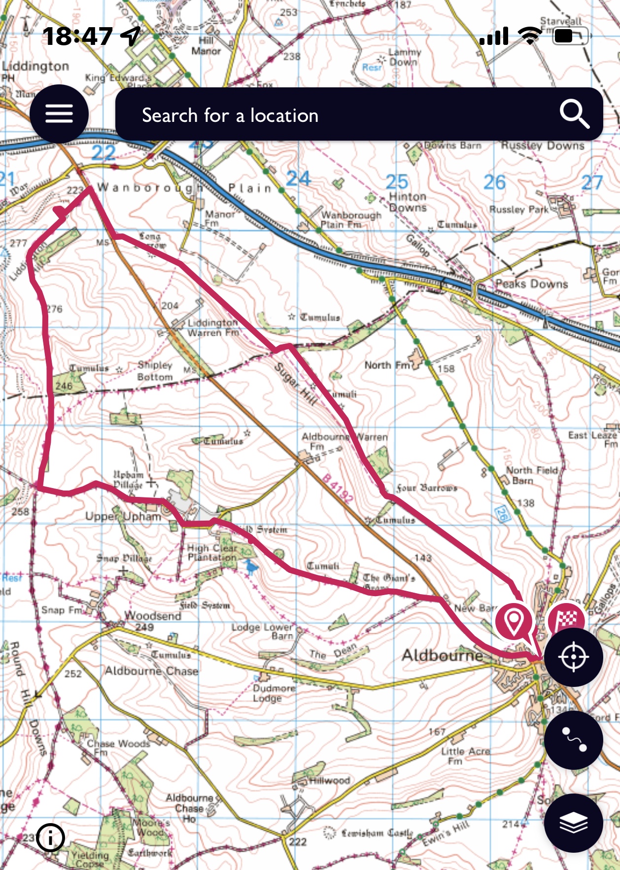
Walk 50 or 100 if you start from the beginning started by a pub – not open, and a bridge over the Kenneth and Avon Canal a few kilometres outside of Devizes.

It was good to see that the canal was being used and we also spotted a good solid looking path – something to keep in mind for later. We hadn’t met until 10am which is unusually late for this group, but the sun was shining even if it was a bit cold at the edges.

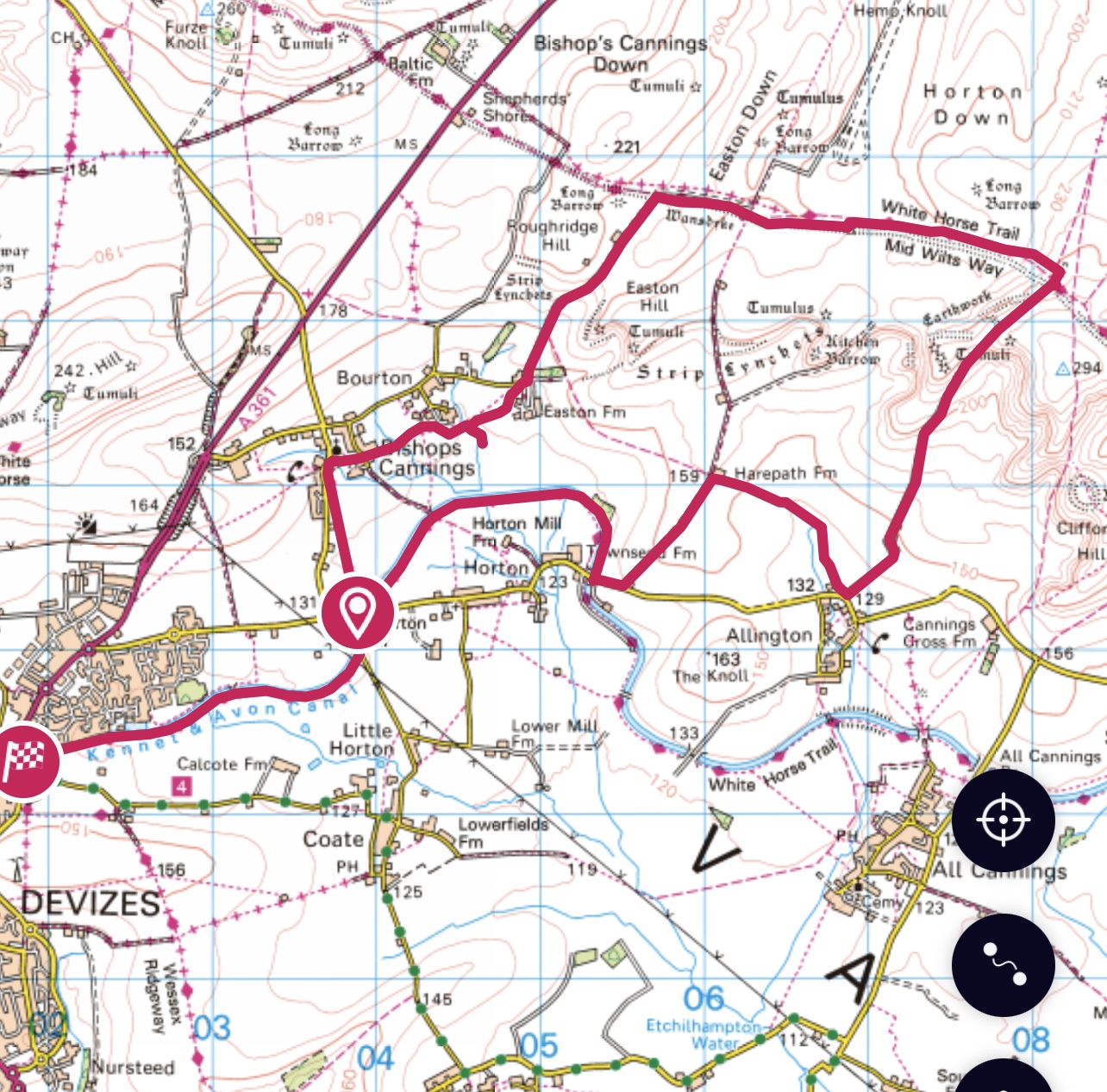
Three of us walking today, Maddy and myself plus a new SPR member – Pip. Don’t think we put her off. Our path was across fields to Bishops Cannings and we had a small view of the village, including an outdoor puppy training class!

So through and out of the village and towards Easton Farm. Easton Hill with its tumuli was to our right.

This whole area of Wiltshire Downs is littered with Long Barrows, Tumuli and a Kitchen Barrow, there are also Strip Lynchets around the hill , formed from farming and soil slippage. Having got on the top of this rise we turned left and onto Wansdyke.

Wansdyke is an early medieval defensive linear earthwork where the ditches face north. It also is now named as the White Horse Trail and the Mid Wilts Way – so many way marked paths nowadays. We chose to walk on top of the ditch most of the way but after a while the route moved to the north of the ditch on to flatter ground. This was a great bit of the walk.

We’d had coffee at the first farm and then settled for lunch on the bank of the earthwork.

After our break it was nearly time to turn right and after a short while still at height we started to descend along an extended spur. The views of undulating and curvaceous hills was magnificent and provoked much discussion around the ice age, glaciers etc. we had many good conversations all day.

We came down to a road into Devizes and quickly diverted back into farm land , back down again to the road but this time our path took us along the canal. The original plan was to just walk back to our drop off point but we discovered as we set off for our walk, that Jane wouldn’t reappear until at least 4 pm …. So we decided to keep walking along the canal to the edge of the town.

The path was good, muddy in places but quite passable. We only saw one boat moving along, very wide for a canal boat but then we realised this canal was wider than normal. One more boat mooring just as we left the canal bank. We thought it might be busier on a sunny Sunday, even if it was February.

Some good canal ‘furniture’, a wonderful brick bridge and a splendid swing bridge. A few lived in boats and some being tended. Oh, and of course a swan. It wouldn’t be a walk next to water if I didn’t include a swan!

Really enjoyed this walk, good company and varied splendid scenery. I hadn’t originally planned this one in but I’m glad I went and it would have been a damp number 50 if I had left it until the next day!

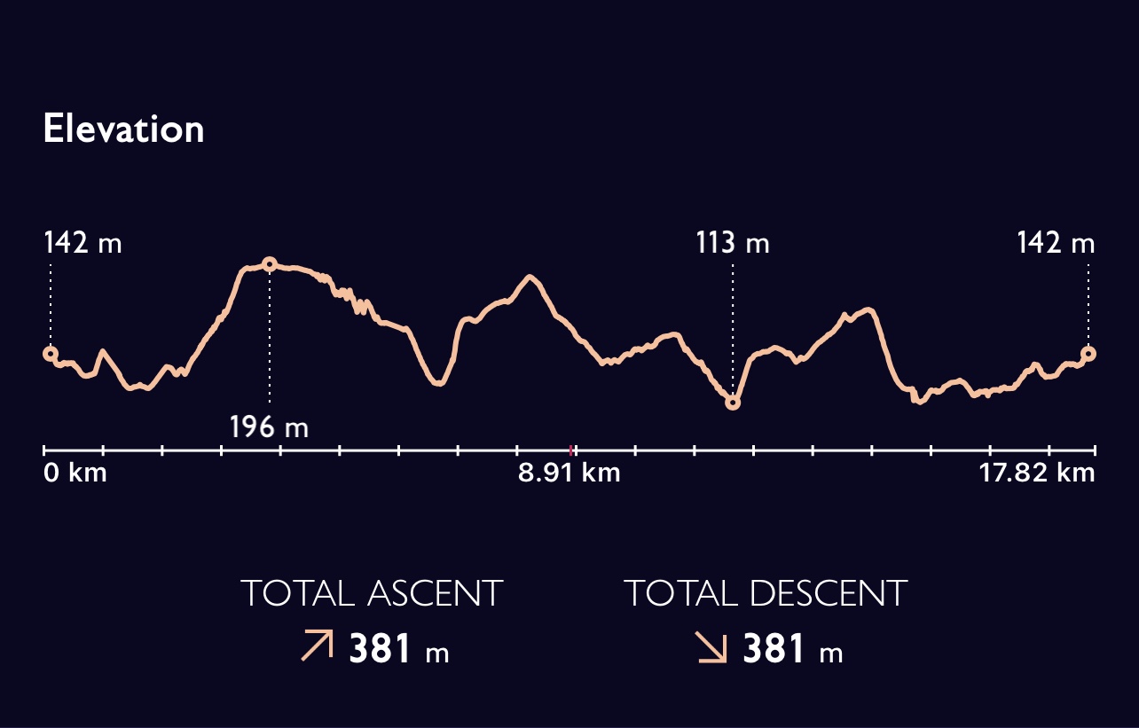
16.27 kilometres today – mostly at quite a good pace but with a leisurely lunch to eke out the time and we still needed to wait at the end!

So what next- not quite ready to finish this challenge yet.

The Yet another 50 ! Challenge is to complete these by July 20th- that will be a year of walking. If I feel really ambitious I might go for by my birthday – at the beginning of that month. We will see how the next few months pan out ! Where will I go for walk 101?

The next 50! Walk 49 – 26/02/2022

Another bright day and a good forecast – not a walk I had originally planned to do with SPR but in a quest to complete my self set challenge I decided to give it a go. Not too far to travel.

Our starting point was Aldbourne which I had seen signed many times but never been to visit. Whilst parking by the village pond I realised it was not that far from Lambourn and easily reachable.

Our route took us through the village and alongside an impressive village green and large wealthy looking church. I suspect that this Wiltshire village may have been on an important route from the Cotswolds and been a provider of either sheep or fleeces.

We followed at track which climbed steadily upwards until we reached the top of a hill and we were able to walk along the ridge of Sugar Hill. Quite a sharp escarpment to our left (west) and a well defined straightforward path.

There were four of us walking today – Jane, Debbie, Betty and myself.

At the end of the ridge we dropped down to the road and luckily there was a path inside the field. Familiar surroundings visited on day 2 of the Ridgeway. This time going up hill to wards Liddington Hill. Just as on my previous walk we stopped in the copse by the WW2 bunker – a memorial woodland overlooking the edge of Swindon. Coffee and snack time.

We had been quite warm up until this point but as last time there was quite a strong wind and as we rejoined the main path the virtue of walking in the other direction was realised. Walking into the wind is not much fun. We did have about four kilometres to go along the Ridgeway so it was just a matter of battling against it and enjoying the view!

We did eventually turn off taking a sharp left turn and headed towards Upper Upham. This quite muddy track was a byway and we soon met a couple of motor cyclists coming towards us.

The path met the village and we awarded ourselves a lunch stop in the sunshine sitting on a wide grassy bank. On the map there are medieval villages of both Upham and Snap marked and also evidence of Field Systems. As we set of we look back and can see a very splendid large house – Upham House.

More motorbikes this time in our direction – not an obvious byway and the ruts were so deep that even the most reliable ‘defender’ may have struggled not to catch its undercarriage on the soil.

A very round copse made me wonder if this was once planted by a rich estate.

The path continued down hill until we reached the road into the village which sadly we had to walk on for about one and a half kilometres. This had been a good walk with sun shine and wind but no rain! Back to the village pond. 16.5 kilometres today.

The next 50! Walk 48 – 25/02/2022

So today should have been a trip to the Wye Valley but unfortunately one of the walkers had Covid so that ruled out two of the three of us! So left to my own devises I decided to try a walk nearer to home. When I walked the Ridgeway I reflected on the fact that it had been many years since I had driven up through East Hendred to Scutchamer Knob and also that I had never walked through Chilton which is quite close by.

I had got a rough idea of a route and knew I couldn’t be too long as I was setting off quite late. The afternoon was quite fine with some blue sky and I made my first decision to stay up on the Ridgeway for as long as possible. I knew whatever route I took would mean going down and coming back up again! So decision one was to continue until I had just gone under the A34 and then make my next choice.

So down to Chilton, Upton or maybe Blewbury? I chose the in between option and decided on a route I hadn’t previously walked which went straight from the Ridgeway through Alden Farm and down to Upton. This crossed the old railway line as it swept down to Compton on the way to Newbury. As it came off the escarpment there was a distinct cross roads of paths by some shrubby land and I made a note that this would be a good place to explore another day.

All was going well until I reached a very large metal gate, well over 6 feet(2 metres) high which was padlocked but did helpfully have a sign on it saying ‘Public Footpath’ , ‘Dogs on Leads’. The gap on the right had been wired up and on the left there were some very large lumps of concrete which just left a small gap. Nothing ventured …. ! Continuing on my route I walked through the farm and on down towards the village. Very clear views across towards Wittenham Clumps and to the few remaining remnants of Didcot Power Station – the familiar cooling towers now lost from the landscape.

Really strange coming out onto the main road as I had driven passed this lane twice a day at least, for over twenty years. Before I reached this point and after merging with the more main track down from the ridge I was pleased to see that the splendid and unique tree house built by a past parent was still intact. A platform and a round house high up in a tree – he was a set designer for shows like the ‘Lion King’ – great the year he helped us when we produced Charlie and the Chocolate Factory for a summer play!

Almost immediately it is time to turn away from the main road again, ignoring the obvious track and taking the gate that led to a footpath. Quite soon this joined the route of the railway line. Upton used to be the first stop out of Didcot as the train headed for Newbury and the coast. The track is set deep down in a narrow cut between to hill sides and it is difficult to tell what would have been natural and what carved out.

The cutting gets deeper and deeper, the path running along the top of the bank and over a well preserved brick bridge before it divers away to Chilton and the railway line sweeps round and down to Compton. This would have been a splendid trip.

The path comes into the village of Chilton which is now embraced by the A34, even separating the village from the school. There is a rather quaint little church and then the village hall. I’m sure I’ve been there for a party in the distant past! Now for the bit I didn’t much like – the footbridge over the A34 – I don’t mind heights or bridges but there is something about climbing the steep gradient up and over that road below which quickens the heart and promotes a sense of relief at the other side!

I have been to Chilton School both the old buildings and the rather splendid new one, many times in my professional career. I’d attend sports days, Year 6 leavers parties and much else but I’d never walked up the track alongside the school grounds which would lead me in a direct , diagonal route back up to the Ridgeway and only a short distance from my car. As the landscape opened out to my left an idyllic country scene emerged. To my right a lot of new housing built on the edge of the Rutherford and Appleton area of the Harwell site. This is now a business and Innovation Centre including the Diamond Light Source Synchrotron. When it was originally developed as the research area for UK atomic energy authority it brought a wealth of scientist to the area. It still forms part of Science Vale UK.

A straight forward a pleasant walk back up and my choice of taking this path which was a little more gradual than some possible ascents was validated. Back to the car and I decided to finish off by exploring the wood and the mound which is Scutchamer Knob – a possible burial site of a Saxon King. The sun hadn’t quite set – I should have waited but there was so much debris on the road on the way up to the hill that I preferred to drive down whilst I could still see !

Not quite 9 miles / 14 .4 km but a very enjoyable walk.

The next 50! Walk 47 – 22/02/2022

Today’s walk was one planned with SPR and started at Moreton in Marsh which is in the Cotswolds. We did experience mud, (bit of a clue in the name) and rain, wind, sun and rainbows but we had a good day and walked 17.6 kilometres. The we was Annie, Mirella and myself – so familiar companions.

Our path led us from Church Lane passed some allotments and along to a field in a southerly direction away from the town. Having crossed a stream we were chatting away and continued on a very definite track which we then realised was not our route and we had to back track until we came across a gate with a rather discrete sign – much clearer on the other side!

Next to hedgerows skirting passed farm buildings and on until we made a complete right angled turn to go almost due East. Our next marker would be crossing the River Evenlode and a railway line before we came to the actual village of Evenlode. Luckily although the approach was indeed a little ‘damp’ the river was still contained within its banks and there. was a good bridge. Swiftly followed by the railway – however many times I do it, it always seems a little risky crossing the tracks!

Now we are in a green lane and looking for a right turn which alludes us the first time of passing as there are no signs and just a gap in the hedge to a clear path across a field. First signs of rain and a rainbow. By the time I think about my coat the moment has passed!

On a little further and we decide that the wall of the church will give us a little shelter for a quick coffee and snack. As we come out into the village we are aware of several very impressive buildings- certainly plenty of wealth in the past and I suspect also currently.

We are on the road now for quite a stretch but in many ways it is quite a relief from mud! Over the railway line again , quite a flat area and evidence of tributaries into the Evenlode. The colour of these trees caught my eye across the fields.

The lane takes us through a very large and old farm area with some impressive buildings and then brings us in to the village of Broadwell which has a wonderful village green. Although it’s not long since coffee we decide to have an early lunch. This is a large rich village and there doesn’t appear to be a church. Our route takes us out passed the pub and then there is a church and a Manor House detached from the rest of this attractive village.

Now we head out still along a road and then cross the main road which is the Fosse Way, a Roman Road. The road approaches Donnington and we pass around the back of Donnington Manor with it’s walled haha and a view looking out over a wide area. Down through fields and some wooded areas.

We enter our last village – Longborough. This looks very much like somewhere you’d like to live. Many spring flowers are already out and there are several sun trap areas.

As we leave the village we are walking across fields and although our route looks straight forward it does take us longer than we anticipated. Not long before reaching Moreton again we find a plaque which gives an explanation of the route we have followed much of the way – The Monarchs Way. Apparently we have followed the route that Charles 1 followed after loosing the Battle of Worcester.

In 1646 there was also a civil war battle near Donnington.

We did stop to finish our lunch before we came along the back of the town and emerged by ‘Pub on the Marsh’. A thriving town with the weekly market and unfortunately no time for a cup of tea before our transport arrived!

Due to the ground conditions and the wind we all felt quite tired after our 11 mile walk. We had all enjoyed it though and an area to revisit.

The next 50! Walk 46.5 20/02/2022

I wasn’t sure whether to use this walk as one of my 50 and I hesitated from writing up walks I’ve done since until I could be sure I would meet my target of 50 by the end of February.

In retrospect I decided to give it a little attention and I had already set a precedent of an extra half a walk in my first block.

My hesitation was over distance – only 5.5 km and the fact that it was a very familiar route. Some of the circumstances around it however do warrant its inclusion. On the 18th there was quite a fierce storm which had a detrimental affect on many trees and sadly, across the UK on several lives. A day indoors but also one of slight anxiety knowing my younger son was flying to Seville.

The day passed and I was due to walk at Symonds Yat on the Saturday. This was cancelled due to flooding and debris and still some quite strong winds. By Sunday having followed Alex’s marathon progress on the race app I was feeling more than ever the need to go out for a walk so set off on my familiar route down the lane.

Many sticks across the path and although still feeling very saddened by the lack of the horse chestnut trees, did inwardly feel quite glad that they hadn’t been further decimated by wind or caused any accidents.

It was very blowy but not too bad, only a few people out and all with dogs as if a walk was a necessity rather than a pleasure. Most looking not very happy walking towards me.

Undeterred I continued through Lockinge and along to the church, admiring the bank of snowdrops which were still holding on. All the way round there had been puddles and bits of branch etc in the road and on the path . So my usual route on the path above the artificial fishing lake and through the gate onto the field behind Barton house.

The going was quite hard, rather blustery and perhaps tiping over that balance of invigorating. As the field narrowed I could see a really big tree, quite possibly an Oak laying right across the path. I approached further and it became obvious that there was no way through. I certainly hadn’t got the will or the athleticism to clamber over the trunk. So turning round was the only option .

As I came out onto the road and down to the car park by the wood the force of the wind seemed to increase and I really had to concentrate as I went passed the Parkinson’s.me garden and into conker alley.

It very soon became apparent why everybody I’d met earlier looked so miserable. Just staying on my feet took real concentration, there was even once of twice where I wondered if I had enough strength to get home. Where the trees had been cut down there was no protection at all.

Hedgerows as I got into the lane did give some respite but what an incredibly hard couple of kilometres. Strangely exhilarating though,yourself against the elements – but glad to get home for a cup of tea!

I c

The next 50! Walk 46 – 16/02/2022

Another walk with a dog today -‘Bramble’ a long haired Jack Russel, and a dear friend who used to be a teaching colleague and is the founder of the Bateman’s Trust in India. Not too long a walk today as Alex has recently had Covid and is still not regained her full stamina. We also had a purpose of scoping out a coffee stop in a village shop!

We met and parked at East Challow village hall and set off up the hill passed the church and into the estate before emerging at the top of Hedgehill Road and taking a path to the recreation ground. We crossed the end of the football pitch inorder to meet the track we needed and I reflected that I had driven down this to get to the parking space to watch football, in the distant past. Not sure I fancied it today.

We had skirted round the back of the school, Alex had done a supply day there once and I could remember football matches when I taught in Wantage and the ball nearly always went over the hedge out of the school grounds.

Very contrasting weather to my last two walks as it was very windy today. As we turned right and went across this top track to Childrey it was really windy and it was almost too strong to have a conversation – but we did manage. As we dropped down a bit into the village it became a bit easier.

The village shop is delightful and sold some amazing but expensive things and had excellent coffee and cake- highly recommended. Another retired headteacher came in and we had a chat and both remembered the person who used to run the school in the village!

Passed the village pond and through a road of ‘once council houses’ and along a track. We met the most enormous off white Irish Wolf Hound who was very friendly but was clearly quite a struggle to control. This quite good path continued to the edge of the village of West Challow. We crossed over the canal.

This is a section of the Wilts and Berks canal which was built in 1810 to link the Kennet and Avon canal to the River Thames at Abingdon and until the Great Western Railway dominated the area was a useful route for the movement of stone and coal. This part is not navigable but some areas have been cleared so that they contain water and there are paths along good sections of the bank.

We continued along this route crossing the road through the village and continued until we came out very close to the cars in East Challow. Quite a bit of conversation plotting and planning some fundraising ideas.

It was very muddy in sections and we had to practice our good balance. Back at the cars we did a swap, I’d got her some clay from my sculptor to be able to use in school this week and it was exchanged for a jar of freshly made marmalade! I think I did well. This section was 5.5 km.

I decided to continue along the canal which was dissected by the A417 at this point! In my look at the weather first thing in the morning I thought I had still got time left before rain. So along the canal and noticed there had been some tidying up of the trees and an effort to put bark on the path so not quite so muddy in this section.

A new path had been created in an area to the left of the canal with a bridge over from the new housing estate. I guessed this would only loop round through a shrubby area which often used to flood and was also known for its newt population. I discovered a large pond that I didn’t know was there and then back to the canal.

Past the entrance to Stockham Farm and then up into the estate. Familiar territory, I used to teach cycling proficiency on these roads and great to see children out to play at the school where I taught for just over nine years. By now my weather forecasting had failed me and the light rain had turned to a squally shower. The one day I wear jeans on a walk!

Back out onto the A417 and as quickly as possible passed the numerous new houses that are springing up everywhere and back down to the car. The rather small village school must be bulging! So just over 9 km but a rather wet finish – suppose I can’t have sunshine every time.

The next 50! Walk 45 – 11/02/2022

Still in Surrey and starting and finishing today in Shottermill, so a Surrey day today. Lucky enough to have two companions today, Sam who will be the navigator and Toby dog who like me will be following the route. I’m still recording it but not really looking during the walk! Yesterday my app told me I was canoeing but all has now been revealed so hopefully I should only be walking in future!

We are heading north towards an area called Polecat and so quickly we are away from houses and into woods and the dark loamy soil that predominates around here. Firstly houses built to house builders as the area rapidly expanded. Past a school – I still feel very comfortable with the sound of children out to play. There are pockets of National Trust land in this area and it’s not long before we pass into one. New gates made of metal are gradually replacing old wooden ones.

The path is parallel to the A287 and there are one or two largish houses below our route. After about an hour we stop for a drink , taking advantage of the sunshine and reflecting on how ridiculously warm it is. Toby is very content to play with a stick.

I realise I haven’t taken any photos yet and as we set off again I take a shot, if nothing else it illustrates what amazing weather we had!

It’s been a long time since I’ve walked with a dog – ‘Cairn’ the border collie was good company on walks and only rounded us up a little bit if we were out with a group!

Our route continued upwards until we reached the edge of Hindhead Common and we set off round the edge of the Punchbowl on the old route of the A3 before a tunnel was built. We’d just walked over that!

After a while we climbed up through a steep bank until we reached the old, old road and up on to Gibbet Hill. Highway men and the like were hung incarcerated by chains and an iron casing but in such a position that others could see- to try to deter them.

Such great views today in so many directions, all different and all enjoyable to see. Blackdown, the South Downs and even through to the Shard and Canary Wharf on the horizon. Not quite clear enough as a bit hazy in the distance but two other people came along who had spotted the area previously and pointed out where they were.

Back down through a wooded area following some paths used as byways – not for ordinary cars! We rejoined a path we had taken on the way up and then a further different loop passed some huge pine trees which formed a very stately and impressive line. Back through a field used for school sports and down to the houses.

A diversion at the end to a great little cafe and a much needed sausage sandwich! Another great walk in this area and excellent company!

The next 50! Walk 44- 10/02/2022

Back down to the Surrey/ Sussex border for this walk and even a momentary step into Hampshire. It’s great because the terrain is so different from home, more wooded, more Heath like but yet names of places are familiar from my childhood- places where friends from school lived or signposts driven passed. Thank you to Sam for his route recommendation and series of photos to keep me on track. A few juggling moments but mostly correct navigation!

So again not too cold and no rain, amazing for February- my route started at my hotel opposite the station and went along King’s Road – renamed after King Edward VII arrived by train at Haslemere and then travelled by carriage along this road and through to the Sanatorium at Easebourne. Another place from my past, did a day there for service as part of my Queen’s Guide – many years ago.

The route took me along this road and then slightly to the left through some housing and then back down to the end of King’s Road as it met the main road to Fernhurst. Across this and then my first mistake, I didn’t expand the map enough to see I needed to cross the stream so took a wrong turn. Backtracked and then on my way to Camelsdale.

A section along the road and my second mistake, not sure how possibly switching between screens. Oh well had a conversation with a stranger as he’d obviously seen me walk passed him twice and then I really was on the ‘Sussex Border Path’ – this seemed quite special as my childhood home wasn’t too far down the road.

This path would skirt above the village of Linchmere before heading south east and through and around Stanley Common. Several areas are fenced off as nature reserves.

A great mix of trees around here and well marked paths such a different landscape from home.

The path took an abrupt turn through almost ninety degrees and followed the line of some pylons although there was still plenty of ferns and gorse. This was next to an area called Iron Hill, a significant name for this area due to the proliferation of small iron furnaces with their adjacent ponds and the production of cannons and other armoury. 

Now there is a timber yard and a fun house at the entrance just off of this main path.

I am aware that my path takes quite a sharp turn to the right just before I reach a parking area and set off, I thought, following the Serpent Trail. But something wasn’t right, checked the map again and a short backtrack – I found my tiny path leading through the bracken and came out in the correct place with a path that continued once it crossed the New Lipchis Way. Both of these are paths I either followed for a while or crossed last time I was in the area. Mostly the way marking is good.

The path weaves around until eventually reaches the edge of Linchmere Common, I’m now on the return part of the route. The terrain is very Heath like and there are several paths all going up hill.

I’ve been looking for a good place to eat my sandwich that I bought earlier and luckily as it was now getting rather late I found a very opportune bench. A commemorative plaque indicated this as a favourite view, so only appropriate that I share it.

Refreshed I set off and I’m now heading for the village of Hammer. I cross the road and head up through the village and across the railway line. The next stop is Liphook but the ultimate destination is Portsmouth. Just over the bridge is a stream and the sign for Hampshire, most of the day I have been in Sussex and I will soon renter Surrey.

The River Wey starts on Blackdown which is nearby and the whole area is rich in springs and wells, feeding into the main river. These water sources provide an opportunity for many local mills and I’m looking for evidence of one of these ‘Pophole’. The only footpaths lead beside the stream and there is a brick structure now just a bridge a little way into the wood. The water power was used to drive bellows for smelting and records show there was a hammer for making Iron bars – hence the local name of the village. Cannons for the Navy would have been produced here. In the 1570’s this would not have been such a tranquil spot.

The path leads on to an area called Shottermill, once the site of another mill but now the western end of Haslemere, with it’s own schools. The path comes out close to the railway line and there is a tunnel under this but not for today. My path does go under the railway and continues alongside it, below me are meandering streams and I take a route down to be closer to these.

Back to the road towards Fernhurst, a route I’ve taken many times on my way to Petworth. Across this and I’m back in King’s Road and a cup of tea at my hotel! Another great days walking in this area. Just short of 18 km / 11 miles. Even more amazingly no need for a coat again!

The next 50! Walk 43 – 07/02/2022

Not a very long walk today and part of my potential planning for a Wantage walk which will be offered by SPR.

As I’m advocating the Spring Line Villages I thought that walking close to Letcombe Brook nearer its source might be good.

I made the decision to walk from Letcombe Regis village hall and to try out a couple of permissive paths. I headed along the road passed the cemetery and then turned left and over the brook. This area has been developed, cleared and is well maintained with boards and various paths. I stayed low and nearer to the water, this eventually climbs up to join the higher route.

Just before this point as I was checking the map I turned and saw someone who looked familiar. As soon as he spoke to ask if he could help we both recognised each other – an old family friend. We walked together for a while and then split as he doubled back and I continued along a narrowed track which was heading for Letcombe Basset but which I hoped would provide the path I wanted along the way.

The permissive path came into view and I crossed a field by the hedge boundary until I met my more familiar path up from Letcombe Regis. At a field corner was my usual route marked with a large style and on the other the gate that led to the permissive path, my route for today. I could see across to Hackpen Hill but that was not my aim for today.

My route took me across a wonderfully curvaceous field, next to some woods and then off up to Segsbury Camp.

Having reached the top of this section I was able to look back over the vale. The shadows help to show the beauty of the day!

I walked across another field before climbing over a style and on to Segsbury Camp, a large hill fort also called Letcombe Castle. From where I started I walked in a clockwise direction, covering about a fifth of the circumference before dipping down to cross the road which runs through the area. Back up on the ramparts again and around another three fifths before descending and joining the ridgeway.

Now the familiar white chalk track between Segsbury Farm and the main road. Decisions to be made – down the road to the youth hostel and back to the car or just carry on for a bit – amazing weather.

So I crossed the road and dog legged to continue along the Ridgeway. At Black Bushes Farm I took a left turn along a well defined track .

This crossed the main track from the Youth Hostel (an alternative Ridgeway Path) About half way down this descending field I could see the sign to my left to where I needed to branch off from the main road. Fortunately a strong track across. Saved walking next to the main road. This cut through to Court Hill Road, just below the hostel and I started my trudge down the hill. I could just about see across to Hackpen Hill again- tall hedges and lack of height are not a good combination!

I was feeling a bit annoyed at my route and wished I had left the car at home as then I would have been able to have had a more pleasant descent when I thought I could spot a track in the field on the other side of a wide bank to my right. When I found a good way through I ventured – yes a much more pleasant path and one which I could have taken from the beginning of this section. Credit probably to local dog walkers rather than the OS map!

Back down in the village and passed old houses and a rather quaint building which has become a small shop and tea room at the entrance to a rather expensive retirement village.

Then a path that led round the side of the church, passed the back of the now converted school and out near the car park and the finish of my walk.

Just 9 km today but great weather again.

The next 50! Walk 42 – 01/02/2022

Somewhere completely different today and a drive with SPR – felt privileged and a little apprehensive as I was the only person taking part with Steve the leader. We were off to Abergavenny which was about a two hour drive. Our aim for the day was Sugar Loaf which is a stand alone very nearly mountain (596 m) close to the Black Mountains range.

Having stopped briefly in the town Jane then drove up a small road which took us to a car park about half way up the hill. A really steep climb up straight from the bus but fortunately the path levels for a while. We can look back over the valley of the River Usk.

Looking over to the mountain there are some decisions to be made as to the route. Straight up the front face or further round and up a longer shoulder. We decided on the later as the weather was good- it look as if it might rain but to this point we had been lucky !

As we approached the climb became steeper and the wind is really picking up. The ground is rockier and we each pick our way towards the top. Before we finally reach the summit we look for somewhere for coffee but there is no shielding from the wind. 

And then on to the top having climbed up through the rocks! Now the wind is really showing it’s ferocious self and moving across the top plateau to the trig point is really quite difficult. We had started the walk with the feel of being the only ones on the hill but as time passed people could be seen emerging and transversing in various directions using numerous routes to the summit. Nobody lingered long.

Some good views out towards Blorenge. The clouds are moving around the sky with some speed and although they look rain ladened we have been lucky so far. We are going to have a steep descent and the wind is still strong so we managed to find some shelter on the far side of the hill amongst some rocks and were able to eat some nuts and dates and drink some coffee.

The descent had to be handled carefully, artificial stone steps do not always work well, especially when damp. I decide to use one of my walking poles to help steady me from the buffeting. As we descended it did become easier. I was given the choice of walking along a spur and then going down through a wood or dropping down into the wooded valley. Not surprisingly I opted to stay up as long as possible!

There is so much lichen on the trees really showing the predominant weather conditions. Having made the first part of our descent it’s possible to look back and see the wonderful conical shape of Sugar Loaf .

Lunch by a small pond (tarn) and again some good views towards Ysgyryd Fawr and Steve has suggested he will try to climb this hill soon.

Before too long we start to drop down through woods and the views disappear, but the trees have a certain charm! The path winds it’s way down and we eventually reach a road which ultimately takes us down into the town.

Not a hugely long walk but a rewarding one and again it felt good to be on something that had a very close resemblance to a mountain! 10.34 km.