Back down to the Surrey/ Sussex border for this walk and even a momentary step into Hampshire. It’s great because the terrain is so different from home, more wooded, more Heath like but yet names of places are familiar from my childhood- places where friends from school lived or signposts driven passed. Thank you to Sam for his route recommendation and series of photos to keep me on track. A few juggling moments but mostly correct navigation!
So again not too cold and no rain, amazing for February- my route started at my hotel opposite the station and went along King’s Road – renamed after King Edward VII arrived by train at Haslemere and then travelled by carriage along this road and through to the Sanatorium at Easebourne. Another place from my past, did a day there for service as part of my Queen’s Guide – many years ago.
The route took me along this road and then slightly to the left through some housing and then back down to the end of King’s Road as it met the main road to Fernhurst. Across this and then my first mistake, I didn’t expand the map enough to see I needed to cross the stream so took a wrong turn. Backtracked and then on my way to Camelsdale.

A section along the road and my second mistake, not sure how possibly switching between screens. Oh well had a conversation with a stranger as he’d obviously seen me walk passed him twice and then I really was on the ‘Sussex Border Path’ – this seemed quite special as my childhood home wasn’t too far down the road.

This path would skirt above the village of Linchmere before heading south east and through and around Stanley Common. Several areas are fenced off as nature reserves.

A great mix of trees around here and well marked paths such a different landscape from home.

The path took an abrupt turn through almost ninety degrees and followed the line of some pylons although there was still plenty of ferns and gorse. This was next to an area called Iron Hill, a significant name for this area due to the proliferation of small iron furnaces with their adjacent ponds and the production of cannons and other armoury. 


Now there is a timber yard and a fun house at the entrance just off of this main path.

I am aware that my path takes quite a sharp turn to the right just before I reach a parking area and set off, I thought, following the Serpent Trail. But something wasn’t right, checked the map again and a short backtrack – I found my tiny path leading through the bracken and came out in the correct place with a path that continued once it crossed the New Lipchis Way. Both of these are paths I either followed for a while or crossed last time I was in the area. Mostly the way marking is good.
The path weaves around until eventually reaches the edge of Linchmere Common, I’m now on the return part of the route. The terrain is very Heath like and there are several paths all going up hill.

I’ve been looking for a good place to eat my sandwich that I bought earlier and luckily as it was now getting rather late I found a very opportune bench. A commemorative plaque indicated this as a favourite view, so only appropriate that I share it.


Refreshed I set off and I’m now heading for the village of Hammer. I cross the road and head up through the village and across the railway line. The next stop is Liphook but the ultimate destination is Portsmouth. Just over the bridge is a stream and the sign for Hampshire, most of the day I have been in Sussex and I will soon renter Surrey.
The River Wey starts on Blackdown which is nearby and the whole area is rich in springs and wells, feeding into the main river. These water sources provide an opportunity for many local mills and I’m looking for evidence of one of these ‘Pophole’. The only footpaths lead beside the stream and there is a brick structure now just a bridge a little way into the wood. The water power was used to drive bellows for smelting and records show there was a hammer for making Iron bars – hence the local name of the village. Cannons for the Navy would have been produced here. In the 1570’s this would not have been such a tranquil spot.
The path leads on to an area called Shottermill, once the site of another mill but now the western end of Haslemere, with it’s own schools. The path comes out close to the railway line and there is a tunnel under this but not for today. My path does go under the railway and continues alongside it, below me are meandering streams and I take a route down to be closer to these.

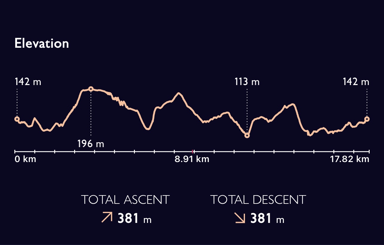
Back to the road towards Fernhurst, a route I’ve taken many times on my way to Petworth. Across this and I’m back in King’s Road and a cup of tea at my hotel! Another great days walking in this area. Just short of 18 km / 11 miles. Even more amazingly no need for a coat again!